Category:17th-century maps of Russia
Countries of Europe: Albania · Armenia‡ · Austria · Azerbaijan‡ · Belarus · Belgium · Bosnia and Herzegovina · Bulgaria · Croatia · Cyprus‡ · Czech Republic · Denmark · Estonia · Finland · France‡ · Georgia‡ · Germany · Greece · Hungary · Iceland · Republic of Ireland · Italy · Latvia · Lithuania · Luxembourg · Malta · Montenegro · Netherlands‡ · Norway · Poland · Portugal‡ · Romania · Russia‡ · Serbia · Slovakia · Slovenia · Spain‡ · Sweden · Switzerland · Turkey‡ · Ukraine · United Kingdom
Specific status: Gibraltar · Isle of Man – Limited recognition: Abkhazia‡
‡: partly located in Europe
Specific status: Gibraltar · Isle of Man – Limited recognition: Abkhazia‡
‡: partly located in Europe
Subcategories
This category has the following 12 subcategories, out of 12 total.
#
- 1600s maps of Russia (2 F)
- 1610s maps of Russia (4 F)
- 1620s maps of Russia (1 F)
- 1640s maps of Russia (1 F)
- 1650s maps of Russia (11 F)
- 1670s maps of Russia (1 F)
M
Media in category "17th-century maps of Russia"
The following 17 files are in this category, out of 17 total.
-

-
 A. de La Motraye. Mare Nigrum (17 century) (cropped).jpg 1,267 × 480; 139 KB
-
 A. de La Motraye. Mare Nigrum (17 century) (cropped2).jpg 728 × 849; 167 KB
-
 A. de La Motraye. Mare Nigrum (17 century) (cropped3).jpg 1,377 × 1,133; 365 KB
-
 A. de La Motraye. Mare Nigrum (17 century) (cropped4).jpg 1,606 × 1,400; 523 KB
-
 A. de La Motraye. Mare Nigrum (17 century).jpg 4,888 × 4,424; 4.77 MB
-
 Caspian Sea (Olfert Dapper).jpg 859 × 742; 291 KB
-
 Cyprus A. de La Motraye. Mare Nigrum (17 century) (cropped).jpg 715 × 314; 44 KB
-

-
 Kola Peninsula map from 1660.jpg 881 × 936; 197 KB
-
 Kunyu Wanguo Quantu (坤輿萬國全圖).Caucasus.jpg 960 × 638; 244 KB
-
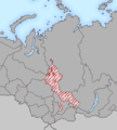 Yeniseian map XVII-XX.png 450 × 500; 31 KB
-
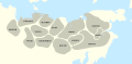 Yukaghir tribes 17th century-es.svg 715 × 353; 1.29 MB
-
 Yukaghir tribes 17th century.svg 715 × 353; 881 KB
-
 Карта Северо-Восточной Руси. Николас Висхер. Голландия.png 2,078 × 1,620; 7.75 MB
-
 Фрагмент чертежа с крепостью Валуйки и монастырем (1687 г.).jpg 2,031 × 1,417; 1.18 MB
-

_and_the_Northwest_Coast_of_America_by_Robert_Dudley.jpg)
_(cropped2).jpg)
_(cropped3).jpg)
_(cropped4).jpg)
.jpg)
.jpg)
_(cropped).jpg)


.Caucasus.jpg)


.jpg)
.jpg)
_(cropped).jpg)