Category:Topographic maps of Armenia
Countries of Asia: Afghanistan · Armenia‡ · Azerbaijan‡ · Bangladesh · Bhutan · Brunei · Cambodia · People's Republic of China · Cyprus‡ · East Timor · Egypt‡ · Georgia‡ · India · Indonesia‡ · Iran · Iraq · Israel · Japan · Jordan · Kazakhstan‡ · Kuwait · Kyrgyzstan · Laos · Lebanon · Malaysia · Mongolia · Myanmar · Nepal · North Korea · Oman · Pakistan · Philippines · Qatar · Russia‡ · Saudi Arabia · Singapore · South Korea · Sri Lanka · Syria · Tajikistan · Thailand · Turkey‡ · Turkmenistan · Uzbekistan · Vietnam · Yemen
Limited recognition: Taiwan · State of Palestine – Other territories: Macau
‡: partly located in Asia
Limited recognition: Taiwan · State of Palestine – Other territories: Macau
‡: partly located in Asia
Countries of Europe: Albania · Andorra · Armenia‡ · Austria · Azerbaijan‡ · Belarus · Belgium · Bosnia and Herzegovina · Bulgaria · Croatia · Cyprus‡ · Czech Republic · Denmark · Estonia · Finland · France‡ · Georgia‡ · Germany · Greece · Hungary · Iceland · Republic of Ireland · Italy · Kazakhstan‡ · Latvia · Liechtenstein · Lithuania · Luxembourg · Malta · Moldova · Monaco · Montenegro · Netherlands‡ · North Macedonia · Norway · Poland · Portugal‡ · Romania · Russia‡ · San Marino · Serbia · Slovakia · Slovenia · Spain‡ · Sweden · Switzerland · Turkey‡ · Ukraine · United Kingdom
Specific status: Faroe Islands · Isle of Man · Svalbard – Limited recognition: Kosovo
‡: partly located in Europe
Specific status: Faroe Islands · Isle of Man · Svalbard – Limited recognition: Kosovo
‡: partly located in Europe
Subcategories
This category has only the following subcategory.
S
- SVG topographic maps of Armenia (24 F)
Media in category "Topographic maps of Armenia"
The following 22 files are in this category, out of 22 total.
-
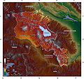
 Ararat Valley Landcover ARM.jpg 10,001 × 7,062; 39.71 MB
-
 Ararat Valley Landcover ENG.jpg 10,001 × 7,062; 39.31 MB
-
 Arasrivermap.jpg 1,484 × 866; 1.57 MB
-
 Caucasus by night.svg 1,155 × 898; 1.04 MB
-
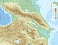 Caucasus topo map-blank.jpg 1,155 × 898; 198 KB
-
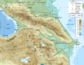 Caucasus topographic map-fr.png 1,155 × 898; 1.35 MB
-
 Armenia Physiography.jpg 2,000 × 2,172; 2.81 MB
-
 Armenia Railway.jpg 3,851 × 2,999; 1.63 MB
-
 Armenia Topography de.png 1,318 × 1,305; 3.49 MB
-
 Armenia Topography he.JPG 1,930 × 1,906; 2.97 MB
-
 Armenia Topography with NKR.png 1,318 × 1,305; 3.47 MB
-
 Armenia Topography.png 1,318 × 1,305; 3.01 MB
-
 Armenia with NKR relief map.png 585 × 599; 654 KB
-
 Armenien topo.jpg 1,400 × 1,314; 677 KB
-
 Caucasus region 1994.jpg 3,119 × 2,392; 1.18 MB
-
 Caucasus topographic map-hu.png 2,000 × 1,555; 4.06 MB
-
 Kurarivermap.jpg 1,484 × 866; 1.57 MB
-
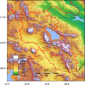
 Relief Map of Armenia.png 1,000 × 1,024; 1.73 MB
-
 Reliefkarte Armenien.png 2,461 × 2,540; 7.87 MB
-
 Reliefkarte Karabach Aserbaidschan.png 4,584 × 2,980; 15.42 MB
-
 Topo map AZ AM de.png 5,660 × 3,516; 19.13 MB
-
 Topo map AZ AM en.png 5,660 × 3,516; 21.11 MB


