Category:Topographic maps of Croatia
Countries of Europe: Albania · Andorra · Armenia‡ · Austria · Azerbaijan‡ · Belarus · Belgium · Bosnia and Herzegovina · Bulgaria · Croatia · Cyprus‡ · Czech Republic · Denmark · Estonia · Finland · France‡ · Georgia‡ · Germany · Greece · Hungary · Iceland · Republic of Ireland · Italy · Kazakhstan‡ · Latvia · Liechtenstein · Lithuania · Luxembourg · Malta · Moldova · Monaco · Montenegro · Netherlands‡ · North Macedonia · Norway · Poland · Portugal‡ · Romania · Russia‡ · San Marino · Serbia · Slovakia · Slovenia · Spain‡ · Sweden · Switzerland · Turkey‡ · Ukraine · United Kingdom
Specific status: Faroe Islands · Isle of Man · Svalbard – Limited recognition: Kosovo
‡: partly located in Europe
Specific status: Faroe Islands · Isle of Man · Svalbard – Limited recognition: Kosovo
‡: partly located in Europe
Subcategories
This category has the following 2 subcategories, out of 2 total.
M
S
Media in category "Topographic maps of Croatia"
The following 22 files are in this category, out of 22 total.
-
 Backsteingotik HU, HR, SK.png 537 × 441; 417 KB
-
 Croatia - Central Croatia - relief map.png 1,889 × 1,812; 8.5 MB
-
 Croatia - East Croatia - Slavonia - relief map.png 1,562 × 1,248; 4.69 MB
-
 Croatia - South Croatia - Dalmatia - relief map.png 2,244 × 2,037; 7.63 MB
-
 Croatia - West Croatia - Istria - Croatian Littoral - Lika - Gorski kotar - relief map.png 1,522 × 1,240; 3.68 MB
-
 Croatia Physiography.jpg 1,995 × 2,373; 1.53 MB
-
 Croatia relief map.png 731 × 707; 882 KB
-
 Croatia topo-ar.jpg 1,400 × 1,078; 1.04 MB
-
 Croatia topo.jpg 1,400 × 1,078; 565 KB
-
 Herceg Novi map.png 2,514 × 2,548; 1.95 MB
-
 HR+HU+SK relief.png 957 × 778; 1.25 MB
-
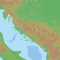
 Istra - blank.jpg 599 × 403; 222 KB
-
 Kroatien topo.jpg 1,400 × 1,078; 564 KB
-
 Mura map Croatia Slovenia.png 2,514 × 2,548; 2.87 MB
-
 Neretva Map.PNG 641 × 489; 649 KB
-
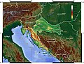
 Relief map of Croatia.png 1,888 × 1,823; 4.92 MB
-
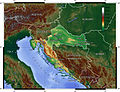
 Reliefkarte Kroatien schaerfer.png 3,786 × 3,646; 26.77 MB
-
 Reliefkarte Kroatien.png 3,786 × 3,646; 17.26 MB
-
 Topografija Hrvatske.png 2,000 × 2,000; 153 KB
-
 Velebit-map.png 1,061 × 1,024; 1.58 MB
-
 Zapadna Hercegovina.png 402 × 392; 267 KB
-
 Неум 1.png 410 × 387; 223 KB


