Category:Topographic maps of the Netherlands
Countries of Europe: Albania · Andorra · Armenia‡ · Austria · Azerbaijan‡ · Belarus · Belgium · Bosnia and Herzegovina · Bulgaria · Croatia · Cyprus‡ · Czech Republic · Denmark · Estonia · Finland · France‡ · Georgia‡ · Germany · Greece · Hungary · Iceland · Republic of Ireland · Italy · Kazakhstan‡ · Latvia · Liechtenstein · Lithuania · Luxembourg · Malta · Moldova · Monaco · Montenegro · Netherlands‡ · North Macedonia · Norway · Poland · Portugal‡ · Romania · Russia‡ · San Marino · Serbia · Slovakia · Slovenia · Spain‡ · Sweden · Switzerland · Turkey‡ · Ukraine · United Kingdom
Specific status: Faroe Islands · Isle of Man · Svalbard – Limited recognition: Kosovo
‡: partly located in Europe
Specific status: Faroe Islands · Isle of Man · Svalbard – Limited recognition: Kosovo
‡: partly located in Europe
Subcategories
This category has the following 6 subcategories, out of 6 total.
Media in category "Topographic maps of the Netherlands"
The following 18 files are in this category, out of 18 total.
-
 2012-NL-prov-relief-3000.jpg 3,000 × 3,440; 2.91 MB
-
 Backsteingotik Nordsee0tx.png 3,002 × 2,124; 5.69 MB
-
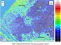 CarteTopoDelftAltitude.jpg 871 × 655; 269 KB
-
 De flora van Nederland (1909-11.) (20820686306).jpg 1,332 × 3,566; 976 KB
-
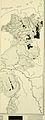
 Dietsland Geografie.jpg 215 × 257; 10 KB
-
 Frieslande.png 2,599 × 1,423; 280 KB
-
 Gotischer Backstein Nordsee & westl. Ostsee.png 3,173 × 2,243; 6.94 MB
-
 Gotischer Backstein um Nord- & südliche Ostsee.png 5,248 × 2,250; 11.33 MB
-
 KonDerNed-10-10-10.png 1,171 × 1,125; 323 KB
-
 Koninkrijk der Nederlanden-10-10-10.png 1,171 × 1,125; 327 KB
-
 Koninkrijk der Nederlanden.png 1,171 × 1,125; 241 KB
-
 Map of Afsluitdijk.png 247 × 303; 15 KB
-
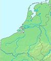
 Nederland-10-10-10(2).png 975 × 1,124; 283 KB
-
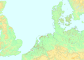
 La2-demis-netherlands.png 631 × 793; 63 KB
-
 Nordsee EN-B-DK.png 3,742 × 2,503; 1.7 MB
-
 Northeast Atlantic bathymetry.png 413 × 323; 347 KB
-
 Gem-Weesp-OpenTopo.jpg 3,042 × 2,944; 1.67 MB
-
 Weesp-centrum-OpenTopo.jpg 3,302 × 3,570; 4.14 MB


.png)


_(20820686306).jpg)