Commons:Graphic Lab/Map workshop/Archive/2023
 | This is an archive of past discussions. Do not edit the contents of this page. If you wish to start a new discussion or revive an old one, please do so on the current talk page. |
Update List of international prime ministerial trips made by Justin Trudeau (no legend).svg
-
 International trips of Justin Trudeau as of February 2020
.svg)
Article(s): en:List of international prime ministerial trips made by Justin Trudeau
- Request
- The map needs to be updated, though I'm not familiar enough with SVG files to do so myself --Kaiser matias (talk) 06:26, 1 January 2023 (UTC)
- Graphist opinion(s)
![]() Request taken by Tcr25 (talk) 19:05, 2 January 2023 (UTC)
Request taken by Tcr25 (talk) 19:05, 2 January 2023 (UTC)
![]() Done —Tcr25 (talk) 19:05, 2 January 2023 (UTC)
Done —Tcr25 (talk) 19:05, 2 January 2023 (UTC)
- @Tcr25: Thanks for your quick help here. Kaiser matias (talk) 00:22, 10 January 2023 (UTC)
List of Pizza Hut locations
-
 Description of first image

Article(s): en:Pizza Hut
- Request
- Please add Ethiopia to the list here. https://addisstandard.com/news-pizza-hut-officially-opens-in-ethiopia --208.127.190.114 16:45, 2 January 2023 (UTC)
- Graphist opinion(s)
![]() Request taken by —Tcr25 (talk) 13:41, 4 January 2023 (UTC)
Request taken by —Tcr25 (talk) 13:41, 4 January 2023 (UTC)
![]() Done —Tcr25 (talk) 13:41, 4 January 2023 (UTC)
Done —Tcr25 (talk) 13:41, 4 January 2023 (UTC)
Making a SVG version of church map
-
 Saint-Antoine-l'Abbaye church

Article(s): fr:Abbaye de Saint-Antoine-l'Abbaye
- Request
- Making a SVG version.
- Making a SVG version of the church map. See also older and more complete version online. Thanks, --Yann (talk) 19:12, 20 June 2022 (UTC)
- Graphist opinion(s)
![]() Done – File:Plan abbaye Saint-Antoine.svg Otourly (talk) 10:50, 21 August 2022 (UTC)
Done – File:Plan abbaye Saint-Antoine.svg Otourly (talk) 10:50, 21 August 2022 (UTC)
Mali Orthographic Projection
-
 Mali (orthographic projection)
.svg)
Article(s): Mali (English Wikipedia)
- Request
- Add the border between Ethiopia and Eritrea.
- Details: For some reason the map of Mali in Africa does not show the border between the East African countries of Ethiopia and Eritrea, could someone please add the border to the map?--JSeb05 (talk) 17:23, 9 July 2022 (UTC)
- Graphist opinion(s)
@JSeb05: ![]() Done. M.Bitton (talk) 22:06, 18 July 2022 (UTC)
Done. M.Bitton (talk) 22:06, 18 July 2022 (UTC)
Time Zone update
-
 Time Zones of the Middle East.

Article(s): Template:Time zones of the Middle East and all articles that transclude this template
- Request
- Update the time zone of Syria & Jorden to be Arabia Standard Time all year round, please refer to this reference (Syria and Jordan to Remain on Permanent DST (05-10-2022). Retrieved on 19-10-2022.)--Aladdin (talk) 07:49, 19 October 2022 (UTC)
- Graphist opinion(s)
![]() Done--Aladdin (talk) 10:57, 20 October 2022 (UTC)
Done--Aladdin (talk) 10:57, 20 October 2022 (UTC)
Legal status of psilocybin mushrooms

Article(s): en:Legal status of psilocybin mushrooms
- Request
- Colorado should be updated as it has decriminalized psilocybin across the whole of the state. Licensed "healing centers" for medical use are expected to begin in 2024. This makes it kind of hard to pin down on the criteria of the graph. I'd advocate changing Colorado to yellow for now for "Ambiguous/partially legal/decriminalized" and then change it to green for "Legal for medical use and decriminalized" when the licensed "healing centers" begin, likely in 2024.
Sources:
- https://time.com/6232212/colorado-decriminalizes-psychedelics-psilocybin-proposition-122/
- https://www.independent.co.uk/news/world/americas/us-politics/midterm-elections-2022/colorado-mushrooms-legal-proposition-122-b2223322.html
Helper201 (talk) 02:44, 5 January 2023 (UTC)
- Graphist opinion(s)
![]() Request taken by A455bcd9 (talk) 13:12, 6 January 2023 (UTC)
Request taken by A455bcd9 (talk) 13:12, 6 January 2023 (UTC) ![]() Done
Done
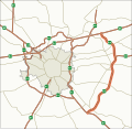
Request for a map showing the Dublin quays and corresponding quay names
-
Description of first image
-
Description of second image (if needed)
-
Description of third image (if needed; don't request too many at once, though)
Article(s): en:Dublin quays
- Request
-- Hi all, happy 2023. I'm looking for someone's assistance in making a map/illustration of the quays of Dublin city, Ireland to show the location of each quay along the river Liffey. At present the article Dublin quays doesn't really give any pictorial explanation of which quay is where, even though this would be the best way to present the information. There are 25 separate "quays" (see list below taken from the page en:Dublin quays). N.B. two of the quays do not have the 'quay' designation at the end of their name ( "Bachelors Walk" and "Usher's Island") but they are quays.
- The name designations of the north roadway are (from west to east): Wolfe Tone Quay, Sarsfield Quay, Ellis Quay, Arran Quay, Inns Quay, Upper Ormond Quay, Lower Ormond Quay, Bachelors Walk, Eden Quay, Custom House Quay and North Wall Quay.
- The name designations of the south roadway are (from west to east): Victoria Quay, Usher's Island, Usher's Quay, Merchant's Quay, Wood Quay, Essex Quay, Wellington Quay, Crampton Quay, Aston Quay, Burgh Quay, George's Quay, City Quay, Sir John Rogerson's Quay and Britain Quay.
Pinging @Goran tek-en
Thanks/Takk! Ridiculopathy (talk) 20:59, 4 January 2023 (UTC)
- @Ridiculopathy I haven't seen this (didn't ping me) but I have written on your other request.
- Please delete the other and we can work from here. --please ping me-- Goran tek-en (talk) 16:09, 30 January 2023 (UTC)
- Graphist opinion(s)
![]() Request taken by --please ping me-- Goran tek-en (talk) 16:11, 30 January 2023 (UTC)
Request taken by --please ping me-- Goran tek-en (talk) 16:11, 30 January 2023 (UTC)
- @Ridiculopathy First we have to decide to the over all area, is this fine?
- If this is the area you want, the map will be very long narrow in width so it will be hard to view the whole at one time and be able to see any details and/or read any added text even in 100%.
- We might consider cutting it into two or three sections showing all together but with a much better relations ship in width*height.
- What else do you want in the map, how much of the roads, buildings or others, tell me what you have in mind.
- If this is the area you want, the map will be very long narrow in width so it will be hard to view the whole at one time and be able to see any details and/or read any added text even in 100%.
- --please ping me-- Goran tek-en (talk) 17:39, 30 January 2023 (UTC)
- Hi @Goran tek-en that extent is perfect, yes maybe split into two or three sections might work. It doesnt have to show any roads really, or buildings, just a text (maybe in bold) that's easy to read, and shows the extent of each quay. Thanks! Ridiculopathy (talk) 19:02, 30 January 2023 (UTC)
- @Ridiculopathy Well I think we will have to include some roads, bridges etc so that people (without your specific knowledge) can orient themselves. Everything we create here at commons is just not for the requester specific needs right now, it's supposed to be useful in many other situations as well, if possible.
- I will do some part and then we can discuss further. --please ping me-- Goran tek-en (talk) 15:05, 31 January 2023 (UTC)
- Hi @Goran tek-en, yeah whatever you think best. If you can get all that info onto the page, all the better. If you wanted to note the name of every bridge on the map, it could also be useful for the en:List of Dublin bridges and tunnels.
- A few points I would suggest would be to indicate the direction of the flow of the River Liffey, and also maybe indicate that to the east of the picture the water drains into the Irish Sea. Ridiculopathy (talk) 16:58, 31 January 2023 (UTC)
- @Ridiculopathy
- ----
- Those drafts are PNG versions of the original SVG file I'm working in and will upload to commons.
- Those drafts are shown for proofreading only.
- ----
- So this draft is 1/4 of the total length showing three of the quays on the northern side. It's a bit hard to show the quays as they also are roads (often) and it has to show each part as a separate entitet.
- Check this draft 1/4-1 and give me feedback, thanks. The width of this image is 1001 px.
- --please ping me-- Goran tek-en (talk) 18:58, 31 January 2023 (UTC)
- Hi @Goran tek-en, yeah that looks good. Maybe if you could put a thin black rectangle or something simple under each quay name (and close to the river) it might make it clearer to illustrate the extent of each quay. For example, in the draft 1/4-1 it is unclear if Ellis Quay also occupies that blank block between itself and Sarsfield Quay. What do you think? Ridiculopathy (talk) 19:22, 31 January 2023 (UTC)
- @Ridiculopathy Yes, it's a problem to understand the extent of each quay, it's not clear on the OSM map either so I guess and you have to correct me.
- I tried to use different shades of grey and a dark outline to show the extent in the first draft put obviously it was not enough. I also always (as far as possible) create illustrations/maps so they also work for most people with color deficiency, sometimes it's impossible but here I think it should work.
- So I made some changes on this draft 1/4-2, remember I have only added three quays here. --please ping me-- Goran tek-en (talk) 13:06, 1 February 2023 (UTC)
- Hi @Goran tek-en that looks great. By the way, its River 'Liffey', not Leffey. Thanks. Ridiculopathy (talk) 15:08, 1 February 2023 (UTC)
- @Ridiculopathy Now you have to check everything for those two parts, especially how the different quays extend because I have guessed.
- Also I haven't decided what I shall do with the small parts that actually belongs to the next part, like to the right of the top one.
- Draft 22/4-1. --please ping me-- Goran tek-en (talk) 18:40, 1 February 2023 (UTC)
- Hi @Goran tek-en great work, thanks. Those two pictures you linked are perfect, except for one small thing: What you have marked as 'Crampton Walk' is actually composed of 'Crampton Quay' for that small bit of quayside between Asdill's Row and Bedford Row, and the rest of what you have marked as 'Crampton Walk' is actually called 'Aston Quay'.
- I'm not sure what you mean about "the small parts that actually belongs to the next part, like to the right of the top one". Could you elaborate? Ridiculopathy (talk) 20:36, 1 February 2023 (UTC)
- @Ridiculopathy
- I discovered a mistake I made which resulted in that I had to redo the most, so please really check everything, thanks.
- "the small parts that actually belongs to the next part, like to the right of the top one" I have made a suggestion for this, look at part 1, 2 to the right.
- I can't find Britain Quay.
- Draft all-2.png
- --please ping me-- Goran tek-en (talk) 16:21, 4 February 2023 (UTC)
- Hi @Goran tek-en, you've done a fine job, thanks. Everything looks great, except for the following points:
- - To the west of Burgh Quay, the tiny bit of Aston Quay we can see is shaded the same light grey colour as Burgh Quay, which makes it look as though that tiny bit is also part of Burgh Quay. Could this tiny sliver be shaded dark grey to distinguish it as a different quay?
- - 'North Wall Walk' should be named 'North Wall Quay'.
- - George's Quay does not extend as far west as Rosie Hackett Bridge. Instead, George's Quay changes into Burgh Quay one block eastwards from Rosie Hackett Bridge, where the road called 'Corn Exchange Place' meets the river.
- - 'Upper Ormond Quay' should be named 'Ormond Quay Upper', and similarly
- - 'Lower Ormond Quay' should be named 'Ormond Quay Lower'.
- - Britain Quay is situated to the east of Sir John Rogerson's Quay, from where the street called 'Benson Street' meets the River Liffey, and goes eastwards until the point where the River Dodder meets the River Liffey.
- I hope the above is clear. Thanks for your help again, Ridiculopathy (talk) 19:59, 4 February 2023 (UTC)
- @Ridiculopathy
- "To the west of Burgh Quay", That tiny bit in "2 is Burgh which there is a line and name for and it's lighter then what Aston is so I don't understand?
- Draft all-3.
- When this is finished I will need the following;
- Name of the file
- Description (/language)
- Captions/s (/language)
- Category/ies at commons
- Structured data/Items portrayed in this file, the Q#, to be able to upload it at commons, thanks.
- --please ping me-- Goran tek-en (talk) 15:39, 5 February 2023 (UTC)
- Hi @Goran tek-en, apologies, I wasn't clear. In image 3 of your "Draft all-3", to the west of Burgh Quay (i.e. the little piece of quay we can see west of O'Connell Bridge), it is shaded the same light grey colour as Burgh Quay, which makes it look as though that tiny bit is also part of Burgh Quay, but it is actually Aston Quay. Could this tiny sliver be shaded dark grey to distinguish it as Aston Quay?
- - 'North Wall Quaynn' should read 'North Wall Quay'
- - You have two 'City Quay's in "Draft all-3". The 'City Quay' in image 4 should be 'Britain Quay'.
- Everything else looks good.
- - I'm completely new to Wikimedia, so I don't know the correct way to describe / caption things. I would say "Map of the quays of Dublin city, Ireland showing the location of each quay along the River Liffey (as of February 2023)" is a suitable name of the file, but not sure. Maybe @Ww2censor knows more?
- Regards, Ridiculopathy (talk) 20:09, 5 February 2023 (UTC)
- @Ridiculopathy
- I will put in some info and then you can change later on if you like.
- Now I understand the issue. The O'Connell Bridge is actually two bridges and I have drawn them as that. The split for sections 2 and 3 is right between the two bridges that's why it's confusing. I have made some changes to those parts now (some are not exactly correct but for the understanding I think it's needed), so I hope this makes sense. Draft all-4.
- --please ping me-- Goran tek-en (talk) 18:33, 6 February 2023 (UTC)
- Hi @Goran tek-en that looks great. I see what you mean with O'Connell Bridge. I would say the image is ready for the page now. You see how much it helps to display the info as a map - it's much more helpful than words. Also, do you think the image would be too long to display linearly? I mean with the 4 images stuck together in a row like the little 1-4 pictures at the top of "Draft all-4."? Ridiculopathy (talk) 14:43, 8 February 2023 (UTC)
- @Ridiculopathy What we can do is to create and upload two versions, stacked and linearly.
- I still need the following;
- Name of the file
- Description (/language)
- Captions/s (/language)
- Category/ies at commons
- Structured data/Items portrayed in this file, the Q#, to be able to upload it at commons, thanks.
- --please ping me-- Goran tek-en (talk) 16:40, 8 February 2023 (UTC)
- @Goran tek-en, I'm still unfamiliar with the conventions of Description, Captions, etc. Possibly a more experienced user like @Guliolopez might be able to help? Thanks. Ridiculopathy (talk) 18:13, 8 February 2023 (UTC)
- @Ridiculopathy Sorry for asking again, I forgot what you told me before. I will write something. --please ping me-- Goran tek-en (talk) 21:01, 9 February 2023 (UTC)
- @Ridiculopathy Now you can find them here file:Map of the quays of Dublin city Ireland 2023 stacked.svg and here file:Map of the quays of Dublin city Ireland 2023 linear.svg.
- Please check all the information, also links for wikipedia, wikidata and structured data.
- If you are happy with this please put the code
"{{section re.solved|1=~~~~}}"(without the ".") on this request so it can be archived, thanks. Done
Done
- --please ping me-- Goran tek-en (talk) 19:02, 10 February 2023 (UTC)
- @Goran tek-en Thanks Goran tek-en. Looks great. Template:Section re.solved Ridiculopathy (talk) 01:01, 11 February 2023 (UTC)
- @Ridiculopathy You misunderstood me, the code should put out like this (look in edit mode) :This section was archived on a request by: --please ping me-- Goran tek-en (talk) 11:29, 11 February 2023 (UTC)
- @Goran tek-en Thanks Goran tek-en. Looks great. Template:Section re.solved Ridiculopathy (talk) 01:01, 11 February 2023 (UTC)
- @Ridiculopathy Now you can find them here file:Map of the quays of Dublin city Ireland 2023 stacked.svg and here file:Map of the quays of Dublin city Ireland 2023 linear.svg.
- @Ridiculopathy Sorry for asking again, I forgot what you told me before. I will write something. --please ping me-- Goran tek-en (talk) 21:01, 9 February 2023 (UTC)
- @Goran tek-en, I'm still unfamiliar with the conventions of Description, Captions, etc. Possibly a more experienced user like @Guliolopez might be able to help? Thanks. Ridiculopathy (talk) 18:13, 8 February 2023 (UTC)
- Hi @Goran tek-en that looks great. I see what you mean with O'Connell Bridge. I would say the image is ready for the page now. You see how much it helps to display the info as a map - it's much more helpful than words. Also, do you think the image would be too long to display linearly? I mean with the 4 images stuck together in a row like the little 1-4 pictures at the top of "Draft all-4."? Ridiculopathy (talk) 14:43, 8 February 2023 (UTC)
- @Ridiculopathy
- @Ridiculopathy
- @Ridiculopathy
- Hi @Goran tek-en that looks great. By the way, its River 'Liffey', not Leffey. Thanks. Ridiculopathy (talk) 15:08, 1 February 2023 (UTC)
- Hi @Goran tek-en, yeah that looks good. Maybe if you could put a thin black rectangle or something simple under each quay name (and close to the river) it might make it clearer to illustrate the extent of each quay. For example, in the draft 1/4-1 it is unclear if Ellis Quay also occupies that blank block between itself and Sarsfield Quay. What do you think? Ridiculopathy (talk) 19:22, 31 January 2023 (UTC)
- Hi @Goran tek-en that extent is perfect, yes maybe split into two or three sections might work. It doesnt have to show any roads really, or buildings, just a text (maybe in bold) that's easy to read, and shows the extent of each quay. Thanks! Ridiculopathy (talk) 19:02, 30 January 2023 (UTC)
Drawing a historical map
Article(s): w:Republic of Mahabad, w:Azerbaijan People's Government
- Request
- Can someone please draw a svg version of this map (from this source: Robert Rossow, Jr., 'The Battle of Azerbaijan, 1946', Middle East Journal, Vol. 10, No. 1 (Winter, 1956), page 33.)? I think it is historically important and has educational usage especially because it differs from File:Republic of mahabad and iranian azerbaijan 1945 1946.png. --HeminKurdistan (talk) 19:29, 29 January 2023 (UTC)
- Graphist opinion(s)
@HeminKurdistan: I can only use that source as information (can't redraw or copy it). You will have to be a bit more precise in wath you want in this map (railroads, movements, or what) and which is the main subject etc, thanks. --please ping me-- Goran tek-en (talk) 17:50, 18 February 2023 (UTC)
- @Goran tek-en. The main subject is the boundaries of the two self-declared states mentioned above, railroads and movements don't matter. (For example, the fact that the city 'Rezaiyeh' is outside w:Republic of Mahabad, in contrast to the png map linked above, is important). HeminKurdistan (talk) 18:20, 18 February 2023 (UTC)
- @Goran tek-en By the way, thank you for your response and help. HeminKurdistan (talk) 18:21, 18 February 2023 (UTC)
![]() Request taken by --please ping me-- Goran tek-en (talk) 19:47, 18 February 2023 (UTC)
Request taken by --please ping me-- Goran tek-en (talk) 19:47, 18 February 2023 (UTC)
- @HeminKurdistan: I will start working on it but you have to remember that I have zero knowledge of this and I will need your assistance along the way. --please ping me-- Goran tek-en (talk) 19:47, 18 February 2023 (UTC)
- @HeminKurdistan First we have to decide which area the map should cover, Draft area-1, with todays borders.
- If this is not correct please describe or draw a rectangle on a map and show me.
- --please ping me-- Goran tek-en (talk) 20:31, 18 February 2023 (UTC)
- @Goran tek-en. You got it right, this is exactly the same area. Borders have not changed since then, the only difference is that Armenia and the Republic of Azerbaijan were the Soviet Union. HeminKurdistan (talk) 20:36, 18 February 2023 (UTC)
- @HeminKurdistan Now I want you to check this Draft-2 which is the base map. I will fine tune the names etc later on. Tell me what you want edited/added/removed from this base map. If you want more cities you will have to provide GPS coordinates and names, thanks. --please ping me-- Goran tek-en (talk) 18:26, 19 February 2023 (UTC)
- I think Julfa and Razi can be removed. Instead, please add the following:
- w:Saqqez (36.246389, 46.266389)
- w:Sanandaj (35.366667, 46.883333)
- w:Divandarreh (35.966667, 46.966667)
- w:Bukan (36.521111, 46.208889)
- w:Marivan (35.526944, 46.176389)
- w:Salmas (38.194722, 44.764722)
- w:Piranshahr (36.694444, 45.141667)
- Sardasht (36.155278, 45.478889)
- Thanks. HeminKurdistan (talk) 16:51, 20 February 2023 (UTC)
- @HeminKurdistan Please always Ping me as watch is not always on, thanks.
- As the two maps are different I do not really know where to draw the two areas. Can you draw on a map and show me or in other way describe for me.
- --please ping me-- Goran tek-en (talk) 18:07, 20 February 2023 (UTC)
- @User:Goran tek-en I think it is enough to have boundaries are approximately, the important thing is inclusion and exclusion of the cities in the terretories. For example Saqqez, Miandoab, Piranshahr and Sardasht would fall inside the Republic of Mahabad and the cities of Sanandaj, Bukan, Baneh, Marivan etc are outside. HeminKurdistan (talk) 18:34, 20 February 2023 (UTC)
- @HeminKurdistan still very unsure about areas.
- Here is a Draft-3, check everything, thanks. --please ping me-- Goran tek-en (talk) 16:54, 21 February 2023 (UTC)
- @Goran tek-en Thank you for updating the map. The boundaries are different from the source. The northern border of the Republic of Mahabad ends just south of Rezaiyeh horizontally (and it won't include Maku and Salmas). On the northeastern border it reaches southern shores of Lake Urmieh. Will you please add Shahindej (36.679167, 46.566944)? It will be a good indication of its eastern borders because it will fall outside. I think I made a mistake about Sardasht, I'm not sure if it was inside the borders so please remove that city from the map. Eastern borders of People's Government of Azerbaijan should look more like the source (it is somehow vertical). Thank you. HeminKurdistan (talk) 14:12, 25 February 2023 (UTC)
- @HeminKurdistan New Draft-4. --please ping me-- Goran tek-en (talk) 16:06, 26 February 2023 (UTC)
- @Goran tek-en That's marvelous! I have a few corrections:
- Aras Dam was constructed in 1971 but this map shows 1945-46, so it is logical to remove Aras Dam Lake. I think Dunkan Lake can be removed too, if that is possible.
- The northern boundaries of the republic of Mahabad meets Iraq-Turkey border (the three lines reach a common point on the source) so it may be better to move the northern boundary a little bit to the south as well.
- The western side of the southern boundary of the republic of Mahabad may move a little to the north so that it is more similar to the map in the source in terms of shape.
- There are also a few typos:
- Maragheg → Maragheh
- Resht → Rasht
- Erdebil → Ardabil
- Kazin → Qazvin
- Thank you for taking the time to correct these things. HeminKurdistan (talk) 16:34, 26 February 2023 (UTC)
- @HeminKurdistan Draft-5. --please ping me-- Goran tek-en (talk) 18:00, 26 February 2023 (UTC)
- @Goran tek-en Well done, this version looks exactly like the source. Thank you again! HeminKurdistan (talk) 18:05, 26 February 2023 (UTC)
- @HeminKurdistan I will need the following;
- Name of the file
- Description (/language)
- Captions/s (/language)
- Category/ies at commons
- Structured data/Items portrayed in this file, the Q#, to be able to upload it at commons, thanks.
- --please ping me-- Goran tek-en (talk) 18:14, 26 February 2023 (UTC)
- @Goran tek-en
- Suggested name: Map of Iranian Azerbaijan 1945-46 insurgency by Robert Rossow
- Suggested description: "Map of Iranian Azerbaijan during 1945-1946, when it was occupied by the Red Army and the Soviet puppet states named Republic of Mahabad and People's Government of Azerbaijan. Boundaries are approximate and based on a work by Robert Rossow Jr., an American diplomat stationed in Tabriz."
- Categories: Maps of the Republic of Mahabad, Maps of the Azerbaijan People's Government
- Items portrayed in this file: Iran, Iranian Azerbaijan, 1946 Iran crisis, Republic of Mahabad, Azerbaijan People's Government
- HeminKurdistan (talk) 18:42, 26 February 2023 (UTC)
- @HeminKurdistan Now you can find it here file:Map of Iranian Azerbaijan 1945-46 insurgency by Robert Rossow.svg.
- Please check all the information, also links for wikipedia, wikidata and structured data.
- If you are happy with this please put the code
"{{section re.solved|1=~~~~}}"(without the ".") on this request so it can be archived, thanks. Done
- --please ping me-- Goran tek-en (talk) 18:01, 27 February 2023 (UTC)
- @HeminKurdistan Now you can find it here file:Map of Iranian Azerbaijan 1945-46 insurgency by Robert Rossow.svg.
- @Goran tek-en
- @HeminKurdistan I will need the following;
- @Goran tek-en Well done, this version looks exactly like the source. Thank you again! HeminKurdistan (talk) 18:05, 26 February 2023 (UTC)
- @HeminKurdistan Draft-5. --please ping me-- Goran tek-en (talk) 18:00, 26 February 2023 (UTC)
- @Goran tek-en That's marvelous! I have a few corrections:
- @HeminKurdistan New Draft-4. --please ping me-- Goran tek-en (talk) 16:06, 26 February 2023 (UTC)
- @Goran tek-en Thank you for updating the map. The boundaries are different from the source. The northern border of the Republic of Mahabad ends just south of Rezaiyeh horizontally (and it won't include Maku and Salmas). On the northeastern border it reaches southern shores of Lake Urmieh. Will you please add Shahindej (36.679167, 46.566944)? It will be a good indication of its eastern borders because it will fall outside. I think I made a mistake about Sardasht, I'm not sure if it was inside the borders so please remove that city from the map. Eastern borders of People's Government of Azerbaijan should look more like the source (it is somehow vertical). Thank you. HeminKurdistan (talk) 14:12, 25 February 2023 (UTC)
- @User:Goran tek-en I think it is enough to have boundaries are approximately, the important thing is inclusion and exclusion of the cities in the terretories. For example Saqqez, Miandoab, Piranshahr and Sardasht would fall inside the Republic of Mahabad and the cities of Sanandaj, Bukan, Baneh, Marivan etc are outside. HeminKurdistan (talk) 18:34, 20 February 2023 (UTC)
- @HeminKurdistan Please always Ping me as watch is not always on, thanks.
- I think Julfa and Razi can be removed. Instead, please add the following:
- @HeminKurdistan Now I want you to check this Draft-2 which is the base map. I will fine tune the names etc later on. Tell me what you want edited/added/removed from this base map. If you want more cities you will have to provide GPS coordinates and names, thanks. --please ping me-- Goran tek-en (talk) 18:26, 19 February 2023 (UTC)
- @Goran tek-en. You got it right, this is exactly the same area. Borders have not changed since then, the only difference is that Armenia and the Republic of Azerbaijan were the Soviet Union. HeminKurdistan (talk) 20:36, 18 February 2023 (UTC)
- @HeminKurdistan First we have to decide which area the map should cover, Draft area-1, with todays borders.
- @HeminKurdistan: I will start working on it but you have to remember that I have zero knowledge of this and I will need your assistance along the way. --please ping me-- Goran tek-en (talk) 19:47, 18 February 2023 (UTC)
Strange unwated black square
-
 Brajčino within Resen Municipality (example 1)
 -
 Izbišta within Resen Municipality (example 2)


Article(s): mk:Брајчино (example 1), mk:Избишта (example 2)
- Request
- Investigating a solution to a rendition error
- Hello graphists, and hello @Goran tek-en: . There is a strange black square phenomenon occuring in the example files I am showing, and consequently for all files in the category of files derived from the initial one (I forgot which one of them was made first). These are all location maps showing the areas of settlements within the Resen Municipality. I have created maps like these for all municipalities in Macedonia, but these Resen Municipality ones show a black square just above the name of the lake, and I can't remove it with Inkscape, the only program I know how to use (it just doesn't show up there as far as I can see). If there is a solution to this issue, then it can be applied to all the maps in the category that are derived from it (I am willing to do it myself if I am taught how, in order to save you the work). Interestingly, the black square shows only on the image file page and on the thumbnail when used in articles, but not when you fully open the image. I can't make any sense of it. Help would be very much appreciated, as these are very useful maps in pages that are commonly used by our readers on mk.wiki. Many thanks. --B. Jankuloski (talk) 08:31, 18 February 2023 (UTC)
- Graphist opinion(s)
@Bjankuloski06: To my understanding there is a "flowRoot issue, check here Flowed_Text_bug.
If you open File:Брајчино во Општина Ресен.svg in a text editor that piece of code is between lines 11100-11110
<flowRoot
     xml:space="preserve"
     id="flowRoot6089"
     style="fill:black;stroke:none;stroke-opacity:1;stroke-width:1px;stroke-linejoin:miter;stroke-linecap:butt;fill-opacity:1;font-family:Sans;font-style:normal;font-weight:normal;font-size:24px;line-height:125%;letter-spacing:0px;word-spacing:0px;text-anchor:middle;text-align:center;-inkscape-font-specification:Sans;font-stretch:normal;font-variant:normal;writing-mode:lr"><flowRegion
       id="flowRegion6091"><rect
         id="rect6093"
         width="26.59108"
         height="34.18853"
         x="1101.6304"
         y="1962.9479" /></flowRegion><flowPara
       id="flowPara6095" /></flowRoot>
I have tested the file with that part removed and the black square is gone.
I would also like to point out that in this file all the text is converted to outline (not recommended, much harder to translate) but there is still a lot of text related information in the code. So to me some work should be done with that file (and probably all the others) to correct this.
To be clear, this is my opinion and I'm not a svg-code expert but I work with svg-files. --please ping me-- Goran tek-en (talk) 14:31, 18 February 2023 (UTC)
- Thank you for the fix! I would have never thought of that. As for the look, they are not true loator maps in the sense of what is termed as such on Commons. Also, they render rather poorly at the size in the infobox when text isn't set to path; they don't follow the conventions because they weren't meant for international use. It was our own idea for our mk.wiki and we didn't think that there will be a need for them to be translated or be wanted elswhere. We may change the colours to suit the recommendations, but we will need to vote on that and then find a way to automate the process. B. Jankuloski (talk) 22:23, 18 February 2023 (UTC)
- @Bjankuloski06 Also they do not follow the conventions of Locator maps, Conventions/Locator_maps_(blank)
- @Bjankuloski06: So if this is considered Done please set out the "section resolved code" (below in edit mode) so it can be archived. --please ping me-- Goran tek-en (talk) 15:50, 28 February 2023 (UTC)
- @Bjankuloski06: So if this is considered
Creating Maps of Gujarat Loksabha constituencies and Legislative assembly constituencies
For List of Loksabha and Legislative Assembly Constituencies: en:Demographics of districts of Gujarat#Demographics
Article(s): en:List of constituencies of the Lok Sabha#Gujarat (for creating Loksabha Constituencies)
- Request
- Making individual Gujarat Legislative Constituencies Maps from Gujarat Loksabha Constituency Map
-
 Gujarat Loksabha Map

Article(s): en:List of constituencies of the Gujarat Legislative Assembly (for creating Legislative Assembly Constituencies)
- Request
- Making individual Gujarat Legislative Assembly Constituencies Maps from Gujarat Legislative Constituency Map
-
 Gujarat Legislative Assembly Map

Example Maps of different Indian state for making Gujarat maps:
- en:List of constituencies of the Tamil Nadu Legislative Assembly#Current list of constituencies(making individual Legislative constituencies link this)
- en:Tiruvallur Lok Sabha constituency(making individual loksabha constituency like this)
Translation of maps
![]() Done
Done
-
 Tectonic structures around the Anatolian Plate
 -
 Arabian Plate showing general tectonic and structural features

.png)
Article(s): ar:زلزالا تركيا وسوريا 2023, ar:الصفيحة الأناضولية, ar:فالق شرق الأناضول
- Request
- Translate all English texts into Arabic, to make them more understandable by Arab readers. --Aladdin (talk) 08:08, 7 February 2023 (UTC)
- Graphist opinion(s)
@علاء الدين: I think you forgot the section headline so I added one.
If you request a translation you will have to add the translations here for the graphic worker to copy/paste, thanks.
English - Arabic
Bitmap image maps (like those two) are often quite hard to translate so maybe it would be a good idea to create new svg files instead, which can be translated much easier. Please consider this as an alternative to this request.
It's also polite to ask for help not just to tell people what the should do according to you. --please ping me-- Goran tek-en (talk) 18:09, 7 February 2023 (UTC)
- @Goran tek-en: : Unfortunately, I don't have sufficient knowledge and experience in transforming Bitmap images into svg files, in addition the English texts contains some technical terms I'm not sure if I can translate them into Arabic. Concerning the request, I'm not telling any one to do something at least for me, I just wanted to be more focused and direct to the point, I'm sorry if my intention was misrepresented. Aladdin (talk) 06:56, 8 February 2023 (UTC)
- @علاء الدين I'm not expecting you to know a lot about Bitmap or Svg files, I was you giving you information on which you could reflect and make a decision from, and you can always ask here.
- It's always the requester who has to provide the translation (or subject knowledge) in some way, we (graphic workers) do just that, graphic work. There is no way we can have any specific subject knowledge or language capacity for every request here. --please ping me-- Goran tek-en (talk) 16:37, 8 February 2023 (UTC)
- @علاء الدين @Goran tek-en FYI I found and uploaded the svg version of the second file (here), unfortunately texts are outlined so they should be re-inserted to translate it. Sette-quattro (talk) 16:06, 10 March 2023 (UTC)
- @Sette-quattro Thanks for info but the svg base map is not the problem. The problem is need for translations from @علاء الدين or anyone else, English-Arabic. All the texts written here so it can be copied. --please ping me-- Goran tek-en (talk) 16:21, 10 March 2023 (UTC)
- sure, ti was just to ease the work in case @علاء الدين want to provide text. Hiving the image with text object would allow the usage of the translator tool without having ot ask here Sette-quattro (talk) 13:07, 12 March 2023 (UTC)
- @Sette-quattro Thanks for info but the svg base map is not the problem. The problem is need for translations from @علاء الدين or anyone else, English-Arabic. All the texts written here so it can be copied. --please ping me-- Goran tek-en (talk) 16:21, 10 March 2023 (UTC)
@علاء الدين: i upfated the image, now you can translate it on your own with translator tool at this link
Create Malay dialectal variation location map
-
 Similar to this

Article(s): ms:wikt:Templat:ms-dial-peta
- Request
- I have created a template like en:wikt:Template:zh-dial-map but for the Malay langauge. The highlighted country would be Brunei, Indonesia, Malaysia, Singapore, Thailand, Timor-Leste, Sri Lanka and Cocos (Keeling) Island. I would like to request that first-level administrative division for Indonesia and Malaysia are added in this map. Hope this is possible to be made and thank you in advance. --Tofeiku (talk) 13:40, 23 March 2023 (UTC)
- Graphist opinion(s)
- Done - Tofeiku, your request is done: Malay dialectal variation location map.svg
Empty request
-
Description of first image
-
Description of second image (if needed)
-
Description of third image (if needed; don't request too many at once, though)
Article(s): [[]]
- Request
- Details of your request go here… --171.241.31.186 14:10, 10 April 2023 (UTC)
- Graphist opinion(s)
@171.241.31.186: , what would you like to request? You didn't fill out anything. --Donald Trung 『徵國單』 (No Fake News 💬) (WikiProject Numismatics 💴) (Articles 📚) 14:20, 10 April 2023 (UTC)
- As this request was malformed I'm tagging it for archiving. @171.241.31.186: , please fill in a correct request next time. --Donald Trung 『徵國單』 (No Fake News 💬) (WikiProject Numismatics 💴) (Articles 📚) 19:03, 11 April 2023 (UTC)
- This section was archived on a request by: Donald Trung 『徵國單』 (No Fake News 💬) (WikiProject Numismatics 💴) (Articles 📚) 19:03, 11 April 2023 (UTC)
French concession cities in the Bảo Đại period map of the Nguyễn Dynasty
-
 Hà Nội (河內), Hải Phòng (海防), and Đà Nẵng (沱㶞) are represented by white circles, I'd like these to be purple like the other purple areas.
.svg)
- Request
- Details of your request go here… Hello @Goran tek-en: and Happy Easter, I wanted to ask you if you could make the cities represented by a white circle the same colour purple as the rest of French Indo-China. The reason these three (3) cities are pointed out separately is because they're French concession cities (and thus outside of the Nguyễn Dynasty) but because the circles are white they appear to be within the 2 (two) countries, so would it be possible to replace the white part of these circles with purple or is this a limitation of the software used to make this map?
- Yours faithfully, --Donald Trung 『徵國單』 (No Fake News 💬) (WikiProject Numismatics 💴) (Articles 📚) 13:51, 9 April 2023 (UTC)
- @Donald Trung Hi, yes I can but in maybe a week. --please ping me-- Goran tek-en (talk) 14:44, 10 April 2023 (UTC)
- Goran tek-en, Sure thing. Thank you in advance.
 -- — Donald Trung 『徵國單』 (No Fake News 💬) (WikiProject Numismatics 💴) (Articles 📚) 16:43, 10 April 2023 (UTC)
- Goran tek-en, Sure thing. Thank you in advance.
- @Donald Trung Hi, yes I can but in maybe a week. --please ping me-- Goran tek-en (talk) 14:44, 10 April 2023 (UTC)
- Graphist opinion(s)
![]() Request taken by --please ping me-- Goran tek-en (talk) 15:01, 16 April 2023 (UTC)
Request taken by --please ping me-- Goran tek-en (talk) 15:01, 16 April 2023 (UTC)
@Donald Trung: I need some more info;
- Red area
- Hà Nội and Hải Phòng, should they have the red or pink color?
- Yellow area
- Đà Nẵng and Huế, shouild they be yellow or pink? --please ping me-- Goran tek-en (talk) 15:01, 16 April 2023 (UTC)
@Donald Trung: You wrote this in a strange place so I moved it to here. --please ping me-- Goran tek-en (talk) 15:35, 16 April 2023 (UTC)
- Goran tek-en, the circular cities should be purple, the star (Huế) should remain as is. This is because the circular dots are concession cities and were nominally outside of the Nguyễn Dynasty's control. The purple colour would make them the same colour as the rest of French Indo-China, this is to signify direct French control. -- — Donald Trung 『徵國單』 (No Fake News 💬) (WikiProject Numismatics 💴) (Articles 📚) 15:04, 16 April 2023 (UTC)
- @Donald Trung Like this. --please ping me-- Goran tek-en (talk) 15:44, 16 April 2023 (UTC)
- Goran tek-en, Yes, exactly. Thank you for your time. -- — Donald Trung 『徵國單』 (No Fake News 💬) (WikiProject Numismatics 💴) (Articles 📚) 16:29, 16 April 2023 (UTC)
- @Donald Trung New version uploaded Done --please ping me-- Goran tek-en (talk) 16:45, 16 April 2023 (UTC)
- @Donald Trung New version uploaded
- Goran tek-en, Yes, exactly. Thank you for your time.
- @Donald Trung Like this. --please ping me-- Goran tek-en (talk) 15:44, 16 April 2023 (UTC)
- Thank you very much for the edits, and naturally also for your time. --Donald Trung 『徵國單』 (No Fake News 💬) (WikiProject Numismatics 💴) (Articles 📚) 17:18, 16 April 2023 (UTC)
- Thank you very much for the edits, and naturally also for your time.
- This section was archived on a request by: Donald Trung 『徵國單』 (No Fake News 💬) (WikiProject Numismatics 💴) (Articles 📚) 17:18, 16 April 2023 (UTC)
Map of Dunkin locations worldwide
-
 Map of Dunkin Donuts locations worldwide
 -
Description of second image (if needed)
-
Description of third image (if needed; don't request too many at once, though)

Article(s): en:Dunkin Donuts
- Request
- Please change Canada to dark gray as Dunkin Donuts exited Canada in 2018 (note this map does not measure Baskin Robbins which continues to operate in Canada).
https://globalnews.ca/news/4434666/dunkin-donuts-done-in-montreal/ --2600:100C:A210:2BB2:5081:A190:36E:1DB0 19:10, 5 January 2023 (UTC)
- Graphist opinion(s)

Marking this as resolved because there is an .svg version of this map that's up-to-date and in use on the English Wikipedia page (which is the article this was requested for originally). The .png version is used in a few other language Wikipedias and should be replaced with the .svg. Dragon401k (talk) 23:32, 14 May 2023 (UTC)
Modify SVG
-
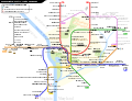 Map needed to be modified

Article(s): en:Washington Metro
- Request
- "–VT" should be added to the end of "Potomac Yard," with only the "VT" underlined, like in "Ballston–MU." The Yellow Line should also be cut back from "Greenbelt" to "Mount Vernon Square." OrdinaryJosh (talk) 00:09, 8 May 2023 (UTC)
- It might be better to put this on hold until May 19, when the Potomac Yard–VT station opens so that the work can be done in one fell swoop. OrdinaryJosh (talk) 04:49, 8 May 2023 (UTC)
- Graphist opinion(s)
![]() Request taken by Twotwofourtysix (talk), pending the May 19 date, as you wish. Twotwofourtysix (talk) 14:33, 15 May 2023 (UTC)
Request taken by Twotwofourtysix (talk), pending the May 19 date, as you wish. Twotwofourtysix (talk) 14:33, 15 May 2023 (UTC)
- @OrdinaryJosh: Done Twotwofourtysix (talk) 08:16, 19 May 2023 (UTC)
- Thank you so much! --OrdinaryJosh (talk) 12:22, 19 May 2023 (UTC)
- I already did the change along with few other minor adjustments. Unfortunately this SVG suffers a recent text-anchor bug and currently does not look right for some station labels. Sameboat - 同舟 (talk · contri.) 13:01, 19 May 2023 (UTC)
- Ah, gotcha. --OrdinaryJosh (talk) 13:05, 19 May 2023 (UTC)
- @Sameboat: Your version doesn't include the shortening of the Yellow Line to Mount Vernon Square, which is why I uploaded mine, even after you have added Potomac-VT Twotwofourtysix (talk) 13:13, 19 May 2023 (UTC)
- Sorry for the oversight. Just fixed it. Sameboat - 同舟 (talk · contri.) 13:25, 19 May 2023 (UTC)
- Thank you so much! --OrdinaryJosh (talk) 14:18, 19 May 2023 (UTC)
- Sorry for the oversight. Just fixed it. Sameboat - 同舟 (talk · contri.) 13:25, 19 May 2023 (UTC)
Post-imperial organisations map - Gabon, Togo, Vanuatu, The Gambia and the Maldives
(this request is also present in the Wikipedia:Graphics Lab/Map workshop)

Article(s): Any article this map already appears on.
- Request
- Alright, could someone please make the following changes to the above map:
- 1) Gabon and Togo joined the Commonwealth of Nations on 25 June 2022, while also retaining their membership of La Francophonie, hence they should be changed to blue-and-red stripes (like Canada, Cameroon and Rwanda) to refect that.
- 2) Vanuatu has been a member of both the CON and LF since independence, so it should also have blue-and-red stripes.
- 3) The Gambia and the Maldives rejoined the Commonwealth in 2018 and 2020 respectively, so they should both be changed from white to red.
- Thanks. Snow Lion Fenian (talk) 16:07, 6 November 2022 (UTC) Snow Lion Fenian (talk) 13:16, 5 March 2023 (UTC) Snow Lion Fenian (talk) 11:12, 4 May 2023 (UTC)
- The Gambia has also been back in the Commonwealth for some years but is blank on the map at present. GPinkerton (talk) 16:14, 7 November 2022 (UTC)
- @GPinkerton: Thanks for pointing that out. I've now updated the request accordingly. Snow Lion Fenian (talk) 00:23, 6 January 2023 (UTC)
- The Gambia has also been back in the Commonwealth for some years but is blank on the map at present. GPinkerton (talk) 16:14, 7 November 2022 (UTC)
- Graphist opinion(s)
Accession of the United Kingdom to CPTPP
Article(s): Accession of the United Kingdom to CPTPP or https://en.wikipedia.org/wiki/Accession_of_the_United_Kingdom_to_CPTPP if the link doesn't work
- Request
Highlight the United Kingdom in one solid colour, Highlight all crown dependencies and overseas territories in a lighter version of the colour used for the UK, Highlight Australia/Brunei/Canada/Chile/Japan/Malaysia/New Zealand/Peru/Singapore/Vietnam in another solid colour. Use a global map with the UK at the centre.
- Graphist opinion(s)

![]() Done @StevoLaker You didn't mention Mexico in your list, but I added it as I assume the intention was to include all CPTPP signatories. Used colors to match File:CPTPP Trade Agreement Map (Q4 2021).svg. Dragon401k (talk) 01:25, 15 May 2023 (UTC)
Done @StevoLaker You didn't mention Mexico in your list, but I added it as I assume the intention was to include all CPTPP signatories. Used colors to match File:CPTPP Trade Agreement Map (Q4 2021).svg. Dragon401k (talk) 01:25, 15 May 2023 (UTC)
- Thank you! This is exactly what i wanted StevoLaker (talk) 10:45, 15 May 2023 (UTC)
Maps of North 24 Parganas and South 24 Parganas
-
 Subdivisions of Hooghly district
 -
 Community development blocks of Hooghly district
 -
 হুগলি জেলার মহকুমা
 -
 হুগলি জেলার সমষ্টি উন্নয়ন ব্লক
.svg)
.svg)
.svg)
.svg)
Article(s): en:North 24 Parganas district, en:South 24 Parganas, bn:উত্তর চব্বিশ পরগনা জেলা, bn:দক্ষিণ চব্বিশ পরগনা জেলা
- Request
- I have looked at the category Maps of India by Project Korikath and I want to say kudos to those who have created the maps in the category (some examples above). I'm already using some of them in Bengali Wikipedia. However, I can't find such maps of Howrah, North 24 Parganas and South 24 Parganas districts of West Bengal in the category, although I found a Bengali-language map of Howrah district elsewhere (হাওড়া জেলা.svg). Therefore, I request the mapmakers (Project Korikath or beyond) to create the maps of North 24 Parganas and South 24 Parganas districts. --Sbb1413 (he) (talk • contribs) 17:22, 9 June 2023 (UTC)
- আমি Maps of India by Project Korikath বিষয়শ্রেণীটি দেখলাম এবং আমি তাঁদেরকে ধন্যবাদ জানাতে যাচ্ছি যারা ঐ বিষয়শ্রেণীর মানচিত্রগুলি তৈরি করেছেন (উপরে কিছু উদাহরণ)। আমি বাংলা উইকিপিডিয়ায় এর কিছু ব্যবহার করছি। কিন্তু ঐ বিষয়শ্রেণীতে আমি পশ্চিমবঙ্গের উত্তর চব্বিশ পরগনা, দক্ষিণ চব্বিশ পরগনা ও হাওড়া জেলার মানচিত্র পাইনি, যদিও আমি অন্যত্র হাওড়া জেলার একটি বাংলা মানচিত্র পেয়েছি (হাওড়া জেলা.svg)। সুতরাং, উত্তর চব্বিশ পরগনা ও দক্ষিণ চব্বিশ পরগনা জেলার মানচিত্র তৈরি করার জন্য প্রজেক্ট কড়িকাঠ বা বাইরের মানচিত্রকারদের কাছে আমার অনুরোধ রইল। এসবিবি১৪১৩ (আলাপ • অবদান) 17:22, 9 June 2023 (UTC)
- Graphist opinion(s)
 Already done – as the team of Project Korikath has already created the requested maps. --Sbb1413 (he) (talk • contribs) 15:55, 15 June 2023 (UTC)
- This section was archived on a request by: Sbb1413 (he) (talk • contribs) 15:55, 15 June 2023 (UTC)
File:Krystal-vs-whitecastle-locations-map.svg
- This section was archived on a request by: Donald Trung 『徵國單』 (No Fake News 💬) (WikiProject Numismatics 💴) (Articles 📚) 21:27, 30 June 2023 (UTC)
-
 Description of first image
 -
Description of second image (if needed)
-
Description of third image (if needed; don't request too many at once, though)

Article(s):
- Request
- Please make Florida purple as it has both White Castle and Krystal.2600:100C:A200:39BC:A586:BA5F:6957:87A
- Graphist opinion(s)
- This was done on 04:09, 23 December 2022 by used "Jacknstock", so I'm marking this section as "Resolved". --Donald Trung 『徵國單』 (No Fake News 💬) (WikiProject Numismatics 💴) (Articles 📚) 21:27, 30 June 2023 (UTC)
Psilocybin decriminalization in the United States

Article(s): en:Psilocybin decriminalization in the United States
- Request
- Colorado should be updated as it has decriminalized psilocybin across the whole of the state. Licensed "healing centers" for medical use are expected to begin in 2024. For now the whole of Colarado should be dark blue to indicate "Decriminalized" according to the key. When the licensed healing centers are established in 2024 or later it can be changed to purple like Oregon. For now the state just needs updating to decriminalized.
Sources:
- https://time.com/6232212/colorado-decriminalizes-psychedelics-psilocybin-proposition-122/
- https://www.independent.co.uk/news/world/americas/us-politics/midterm-elections-2022/colorado-mushrooms-legal-proposition-122-b2223322.html
Helper201 (talk) 03:12, 6 January 2023 (UTC)
- Graphist opinion(s)
![]() Request taken by A455bcd9 (talk) 13:21, 6 January 2023 (UTC)
Request taken by A455bcd9 (talk) 13:21, 6 January 2023 (UTC) ![]() Done
Done
Norwegian polling graph update and alteration/axis extension
-
 Norwegian Opinion Polling, 30 Day Moving Average, 2021-2025

Article(s): * en:2025 Norwegian parliamentary election
* en:Opinion polling for the 2025 Norwegian parliamentary election
- Request
- Graph update and axis extension.
- Can someone please update this polling graph using the latest polls on the English Wikipedia page above so it is up to date, including the 30-day averages bar charts? Can someone also please extend the Y percentage axis to 40% as the Conservative Party (H) have polled over the current maximum of 30% on the graph and gone above 35% in a poll to 35.6%. Helper201 (talk) 16:24, 17 January 2023 (UTC)
- Graphist opinion(s)
Virginia and Colorado historical county maps
-
 Standardized map of Virginia
 -
 Standardized map of Colorado
 -
 Example of what I am talking about as shown in the old style


Article(s): [[]]
- Request
- Hello needing someone who could draw accurately and tweak the new standardized Virginia and Colorado maps to make the county boundaries historically accurate for past election articles. For Virginia needing it to include the Independent city of Bedford within Bedford County. For Colorado, needing Broomfield county removed. Not sure which programs were used to make the original base map but I used inkscape to edit the colors of the county for election articles.
- Details of your request go here… --Putitonamap98 (talk) 01:18, 21 January 2023 (UTC)
- Graphist opinion(s)
Costco Map
-
 Description of first image
 -
 This file, including China, already exists
 -
Description of third image (if needed; don't request too many at once, though)


Article(s): en:Costco
- Request
- Please add China to the list. http://www.news.cn/english/2021-12/08/c_1310358751.htm --208.127.190.114 21:12, 21 January 2023 (UTC)
- Graphist opinion(s)
- There is no need for this request becauseThis image already exists and it is in the article. Ww2censor (talk) 22:59, 21 January 2023 (UTC)
Change map from jpg to svg to later improve the result
My following request was earlier today posted at the Commons:Help desk but I was informed I better make the request here.
I would like to use this 1968 map in Commons and create a new map in SVG format with different background colors of the historical districts of Suriname. A little bit like this map, so maintaining the city/village names, mayor roads, lakes, rivers etc. But then in SVG format of the situation in 1968. I guess I should start with a jpg to svg conversion tool to easily import the lines for the borders, rivers, roads, etc. in a vector/line format and then use a tool like Inkscape to process it in the way I want. Unfortunately the district borders are not shown as a solid line but a repetition of a small line, a dot, another small line and another dot and so on. Can somebody here give me some advice how to start this. Is using a free svg conversion tool a good first step and if so, which one would you use to overcome the problem with the district border lines? Or would you start by importing the jpg file into some free PC software program like Inkscape and let that program do the conversion of the pixels of say a river into lines that can be scaled? Any advice would be appreciated. - Robotje (talk) 17:06, 24 February 2023 (UTC)
- @Robotje Using any (I believe so) conversion/tracking tool will give you a bad result. To me the solution is to import the jpg to e.g. Inkscape but also import high quality screenshots from OpenStreetMaps and other sources with rivers etc. Then you will have to manually draw what ever need in your map and please use file:Maps template-en.svg so that you try to keep the conventions we have. --please ping me-- Goran tek-en (talk) 17:22, 24 February 2023 (UTC)
PNG to SVG
-
 Sool Sanaag Cayn
 -
Description of second image (if needed)
-
Description of third image (if needed; don't request too many at once, though)

Article(s): de:Las Anod
- Request
- Could someone make a new file incorporating the current PNG into an SVG file? Thanks --Billboardbillal (talk) 23:50, 20 June 2023 (UTC)
- Graphist opinion(s)
![]() Done
Done
-
 Sool Sanaag Cayn (SVG Version)

- This section was archived on a request by: BlueCamille chat ! 15:13, 22 August 2023 (UTC)
File:Taiwan relief location map.jpg
-
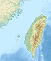 File:Taiwan relief location map.jpg

Article(s): en:Liang Island en:Dongyin, Lienchiang, all Taiwan articles
- Request
- Straightforward fix of map
- In 2019, I literally used Microsoft Paint to put a temporary fix on the map of Taiwan. The dotted line around the Matsu Islands did not extend around en:Dongyin, Lienchiang. The map urgently needs to be changed to (1) add some extra space above Dongyin and (2) put the dotted line in that extra space. Here's a great example of what should be done: [1] (map of Taiwan on lower right). This is not a minor issue or something that can wait four years- it is a travesty of the highest order, and frankly, it's dangerous. It may be arduous to make the change- and the map as is "kinda works"-, but ultimately it undercuts the credibility and reliability of Wikipedia to have something f'ed up this badly. It's like if Ukraine's Snake Island was right on the edge of the map and it wasn't clear if it was part of Ukraine or not. This is not a minor issue, this is big. A mountain imagined as a mole hill is a mountain. --Geographyinitiative (talk) 19:26, 31 March 2023 (UTC)
- Graphist opinion(s)
File:Bohaiseamap2.png
-
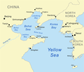 File:Bohaiseamap2.png

Article(s): w:Bohai Sea, w:Yellow Sea
- Request
- I suggest using the more normative 'Pyongyang' and 'Yellow River' or at least adding these forms in parentheses. --Geographyinitiative (talk) 11:03, 3 April 2023 (UTC)
- Graphist opinion(s)
Creating Maps of Gujarat Legislative assembly constituencies
For List of Legislative Assembly Constituencies: en:Demographics of districts of Gujarat#Demographics
Article(s): en:List of constituencies of the Gujarat Legislative Assembly (for creating Legislative Assembly Constituencies)
- Request
- Making individual Gujarat Legislative Assembly Constituencies Maps from Gujarat Legislative Constituency Map
-
Gujarat Legislative Assembly Map
Example Maps of different Indian state for making Gujarat maps:
- en:List of constituencies of the Tamil Nadu Legislative Assembly#Current list of constituencies(making individual Legislative constituencies link this)
Map of Bruttium
-
 Map of Bruttium

Article(s): el:Βρεττία, es:Brucio, de:Bruttium and all other articles on the same subjects in other languages
- Request
- Please remake the file of map of Bruttium to svg format, so that it is easy to translate. I am interested in the Greek translation, but I will give both the Latin and Greek names used in the map
- I suspect you will know better than me whether it is worth copying this map or better to copy a map of the Italian peninsula already in svg. The names of the cities from top to bottom, from left to right as shown below. First in Latin, then in Greek. Please make a map in Greek and one map in Latin. For the translation in Latin I am using the detailed map of Shepherd File:Shepherd-c-030-031.jpg.
- Roma / Ρώμη
- Lucania / Λευκανία
- Laus / Λᾶος
- Sybaris / Σύβαρις
- Thurii / Θούριοι
- Bruttium / Βρεττία
- Tempsa / Τεμέση
- Crotona / Κρότων
- Terina / Τερίνα
- Scylletium / Σκυλλήτιον
- Medma / Μέδμα
- Caulonia / Καυλωνία
- Locri / Λοκροί (the full name is Epizephyrii Locri / Επιζεφύριοι Λοκροί, if you can fit it, please do)
- Rhegium / Ρήγιον
Let me know if I can help. --FocalPoint (talk) 19:52, 13 April 2023 (UTC)
- Graphist opinion(s)
If you have some experience with identifying some of the best maps, then please consider looking at voy:en:Wikivoyage:Travellers' pub#Having a hall of fame for static maps and seeing whether you have any advice that would be worth sharing. I know that there's a big difference between Commons' purpose and a travel guide, but most of the maps they're talking about will be hosted here, and perhaps some of you would be interested in what they're doing. Thanks, WhatamIdoing (talk) 23:38, 17 April 2023 (UTC)
Historic Lincolnshire
-
 Please can Lincolnshire be divided up into its three historic parts similar to how Yorkshire is shown in this image.
 -
 Please can two new images be created out of this image, one with Lincolnshire in its three parts but with no single red area highlighted and a second map (closer up) be created with the three areas numbered 1, 2 and 3


Article(s): Various
- Request
- I have a request for image one to be modified so that historic Lincolnshire is in its three parts as it’s not currently shown on the map in a way that is similar to how Yorkshire is currently shown and also a request for a two new SVG images of just historic Lincolnshire in its three parts with no highlighted areas and for one which is closer up with its three parts numbered so it’s three requests in total. MOTORAL1987 (talk) 08:58, 12 May 2023 (UTC)
- Graphist opinion(s)
Venezuela president recognition map
-
 "Map showing the recognition of Juan Guaidó as acting president of Venezuela:"

Article(s): en:Responses to the Venezuelan presidential crisis
- Request
- Hi! Users that are familiar with the topic know that the presidential crisis in Venezuela has been ongoing for four years, and it hasn't been until recently that it seemingly has come to an end. Naturally, this map: File:Venezuela president recognition map.svg has changed drastically since its beginning in 2019. To reflect these changes over the time, I've thought that an animated file, such as a gif, would be ideal. Are there contributors that could help with this? Many thanks in advance! --NoonIcarus (talk) 22:47, 12 January 2023 (UTC)
- I forgot to ask: if possible, an important aspect to include would naturally be the date where the current frame stands. Thanks again! --NoonIcarus (talk) 10:20, 15 January 2023 (UTC)
- Graphist opinion(s)
Copied from Video and Sound Workshop by 多多123 20:24, 21 May 2023 (UTC)
- @NoonIcarus: I think it's a good idea, although looking at the changes, the only large changes I can notice are all the south america countries turn blue but thats about it. Almost all others stay the same throughout the entire thing.
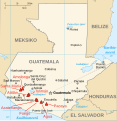
Map of volcanoes in Guatemala
-
 Map of the volcanoes in Guatemala
 -
 Map of Guatemala in Inari Sámi
 -
 combined


Article(s): Listo Guatemala tullâvaarijn
- Request
- I would like only the Guatemalan volcano symbols and labels in the first image to be added to the Inari Sámi map of Guatemala in the second image and saved as a new file so we can use it in an article on the Inari Sámi wikipedia. The volcano labels are missing the diacritics in the gif and the following labels would need to be fixed: Santa María, Atitlán, and Tolimán. I would also appreciate if the symbol and label colors could match the SVG image color scheme better than the bright red of the GIF. Takkâ! :) --Yupik (talk) 09:04, 11 January 2023 (UTC)
- Graphist opinion(s)
- Done, though the inclusion of town names alongside volcanos entailed a degree of awkwardness SmallJarsWithGreenLabels (talk) 00:50, 2 June 2023 (UTC)
Japanese Empire 1939
-
 Japanese Empire, 1939
 -

-

-


Article(s): Manchukuo, etc.
- Request
- (1) Saipan should appear these four maps in the same way it appears on File:Mengjiang map 1939.svg. (This is because Saipan was part of the Japanese Empire in 1939 and not part of the USA yet.) (2) Vladivostok is misspelled as 'Vladivostak'; this should be corrected. --Geographyinitiative (talk) 00:16, 1 June 2023 (UTC)
- Graphist opinion(s)
- Note fixed spelling. Other issue still needs addressing. SmallJarsWithGreenLabels (talk) 23:23, 1 June 2023 (UTC)
- Done SmallJarsWithGreenLabels (talk) 23:50, 1 June 2023 (UTC)
Milan highways
-
 A50
A50 -
 A51
A51 -
 A58
A58


-
 A52
A52 -
 Milan highways


- Request
- Please update A50, A51 and A58 files by completing the A52 path as in maps representing A52 and all Milan highways. Thank you. --InfattiVedeteCheViDice (talk) 14:08, 7 June 2023 (UTC)
- Graphist opinion(s)
Treaty of Accession 1972 European Communities map
-
 Treaty of Accession 1972 European Communities map

Article(s): [[]]
- Request
- I was wondering if the map should be modified slightly to show that the treaty now currently no longer applies to the United Kingdom following Brexit. I was thinking that the best way to show this as unlike Norway which did not ratify following its referendum result and is shown in full red but because the UK did ratify I reckon the UK should be kept yellow but have red stripes though it so it’s still shows that the country did ratify but later withdrew and now the treaty no longer applies to the UK and should be noted that even if the UK ever rejoined the EU this treaty will never apply again as a new treaty of Accession would be needed with the UK. (MOTORAL1987 (talk) 12:37, 11 June 2023 (UTC))
- Graphist opinion(s)
- I think I can add the stripes based on India (claimed and disputed hatched).svg. Let me see if I can add them. --Sbb1413 (he) (talk • contribs) 15:58, 15 June 2023 (UTC)
- Done – however, instead of using diagonal stripes like India (claimed and disputed hatched).svg, I have used vertical stripes because I'm unable to use diagonal stripes. --Sbb1413 (he) (talk • contribs) 16:23, 15 June 2023 (UTC) Edit: I have also marked Greenland for the same reason, except that it is a Danish overseas territory and not a separate state. --Sbb1413 (he) (talk • contribs) 16:27, 15 June 2023 (UTC)
Map of Arabian states (1905-1923)
-
Description of first image
-
Description of second image (if needed)
-
Description of third image (if needed; don't request too many at once, though)
- Article(s)
- en:Federation of South Arabia, en:Protectorate of South Arabia (and other countries in the map)
- Request
- there are no good maps in wikipedia of this region and time period and countries like yemen, saudi, transjordan, Mahra, Dhofar, Kathiri and, Quaiti don't have maps like this one on wikipedia/commons.
Here's the reference: the map -- Abo Yemen✉ 18:24, 3 October 2023 (UTC)
- Discussion
- Graphist opinion(s)
Abo Yemen We do have this jpg version خريطة أهم دول و سلاطين الجزيرة العربية و قبائل قبل 100سنه which seems to be the same. If you want a svg version of this I can help you. --please ping me-- Goran tek-en (talk) 16:22, 26 November 2023 (UTC)
- @ Goran tek-en i want an svg version of it; I tried making some maps of Lahej like this one. I want to make a base map (one with borders only and no red color) and a map for every state colored with red Abo Yemen (talk) 16:29, 26 November 2023 (UTC)
- @Abo Yemen But if you created that map of Lahej, why can't you do the rest you want? --please ping me-- Goran tek-en (talk) 16:46, 26 November 2023 (UTC)
- i would have done it if i didn't have exams at the time of making this request and i'm also very slow at making maps so i thought i'd get help Abo Yemen (talk) 16:50, 26 November 2023 (UTC)
- @Abo Yemen You are also talking about several maps now.
- I will help you with the border version and then we will see.
 Request taken by --please ping me-- Goran tek-en (talk) 16:57, 26 November 2023 (UTC)
- @Abo Yemen
- ----
- Those drafts are PNG versions of the original SVG file I'm working in and will upload to commons.
- Those drafts are shown for proofreading only.
- ----
- I'm using Open Street Map (OSM) as my base map source and the map you have provided as source don't have the same projection as OSM so you really have to check all the borders to see if they are correct.
- In your source map there are black borders, white borders, borders between to different colors and borders with no exact defined line. I have tried to add what I think should be there but you have to tell me what to edit, add or remove.
- Right now all the borders have the same line but I think we have to discuss which border should have what line defining what type of border it is; Country, Province, or what ever you need.
- Draft arabia-1. Feedback, anything goes, thanks.
- --please ping me-- Goran tek-en (talk) 17:06, 2 December 2023 (UTC)
- we do not have a source for provinces in these maps at the moment.
- The borders in squiggly lines would look better if they were more smoother and dashed to indicate that there were no defined borders at that area.
- overall, I find the draft to be very well done. @Goran tek-en Abo Yemen (talk) 19:24, 3 December 2023 (UTC)
- @Abo Yemen
- Did you not read what I wrote above; Right now all the borders have the same line but I think we have to discuss which border should have what line defining what type of border it is; Country, Province, or what ever you need. I need you to tell me which is what.
- What do you mean by; we do not have a source for provinces in these maps at the moment. What do you want me to do with this information?
- --please ping me-- Goran tek-en (talk) 13:18, 4 December 2023 (UTC)
- I'm sorry but i am new to this kind of stuff and i might not give useful info. I just want the Countries' borders on this map (No provinces) and in regions where there are no clearly defined borders, use dashed lines. (Hopefully I gave you some important info) Abo Yemen (talk) 15:44, 4 December 2023 (UTC)
- @Goran tek-en Abo Yemen (talk) 15:44, 4 December 2023 (UTC)
- @Abo Yemen Yes but I don't know which are Countries or Provinces, that is what I need you to tell me, I have zero knowledge of this subject. --please ping me-- Goran tek-en (talk) 16:04, 4 December 2023 (UTC)
- @Goran tek-en Oh my bad. All of them are countries Abo Yemen (talk) 17:02, 4 December 2023 (UTC)
- @Abo Yemen New draft arabia-2. --please ping me-- Goran tek-en (talk) 13:43, 6 December 2023 (UTC)
- @Goran tek-en perfect. Now can you make a version for each country in red like other locator maps Abo Yemen (talk) 14:08, 6 December 2023 (UTC)
- @Abo Yemen As I said to start with you extended your request and I agreed to create this one. As you work with Inkscape yourself I think you can create the others based on this one.
- I will need the following;
- Name of the file
- Description (/language)
- Captions/s (/language)
- Category/ies at commons
- Structured data/Items portrayed in this file, the Q#, to be able to upload it at commons, thanks.
- --please ping me-- Goran tek-en (talk) 17:08, 6 December 2023 (UTC)
- Alright ill make the other versions myself.
- Name of the file: States of the arabian peninsula map (1923).svg
- Description (/language): Map of the states of the arabian peninsula
- Captions/s (/language): (same as desc)
- Abo Yemen (talk) 14:30, 10 December 2023 (UTC)
- Alright ill make the other versions myself.
- @Goran tek-en perfect. Now can you make a version for each country in red like other locator maps Abo Yemen (talk) 14:08, 6 December 2023 (UTC)
- @Abo Yemen New draft arabia-2. --please ping me-- Goran tek-en (talk) 13:43, 6 December 2023 (UTC)
- @Goran tek-en Oh my bad. All of them are countries Abo Yemen (talk) 17:02, 4 December 2023 (UTC)
- @Abo Yemen Yes but I don't know which are Countries or Provinces, that is what I need you to tell me, I have zero knowledge of this subject. --please ping me-- Goran tek-en (talk) 16:04, 4 December 2023 (UTC)
- @Goran tek-en Abo Yemen (talk) 15:44, 4 December 2023 (UTC)
- I'm sorry but i am new to this kind of stuff and i might not give useful info. I just want the Countries' borders on this map (No provinces) and in regions where there are no clearly defined borders, use dashed lines. (Hopefully I gave you some important info) Abo Yemen (talk) 15:44, 4 December 2023 (UTC)
- @Abo Yemen
- i would have done it if i didn't have exams at the time of making this request and i'm also very slow at making maps so i thought i'd get help Abo Yemen (talk) 16:50, 26 November 2023 (UTC)
- @Abo Yemen But if you created that map of Lahej, why can't you do the rest you want? --please ping me-- Goran tek-en (talk) 16:46, 26 November 2023 (UTC)
Abo Yemen Now you can find it here file:States of the arabian peninsula map (1923).svg.
- If you are happy with this please put the code
"{{section re.solved|1=~~~~}}"(without the ".") on this request so it can be archived, thanks. Done --please ping me-- Goran tek-en (talk) 15:50, 10 December 2023 (UTC)
Creating Maps of Talukas(sub-district) of Gujarat
- Request
I have a request for making maps of Talukas(sub-districts) of Gujarat districts.Can you make some maps of Talukas of districts of Gujarat, India.
Here are the talukas list - Talukas of Gujarat: link
-
 Similar to this(Ahmedabad district talukas map)

Checkout Some available maps:
- [File:Gujarat Talukas Map 2011.svg] but it's old version. "In 2013 some new District has been created".
- [2]
- [3]
- [4]
- [5]
- [6]
- [7]
DSP2092 (talk) 06:21, 27 March 2023 (UTC)
- Hi, I found this source, seems updated to 2018, but the administrative division is different than the one in your images (see here a quick export). Is it correct? In case i can generate the map. The best solution would be to find geographical shapefiles from official indian sources Sette-quattro (talk) 07:32, 31 March 2023 (UTC)
- Yes it's a Gujarat Sub-districts (talukas) map.If there's a full map of Gujarat.It's not a complete map. DSP2092 (talk) 17:06, 2 April 2023 (UTC)
- Yes there is the whole country, my question is if the division of sub-distritcs is correct. Do you need one map of all the sub-dostricts of Gujarat, or multiple maps (e.g. one per district)? Sette-quattro (talk) 20:31, 5 April 2023 (UTC)
- One whole map gujarat with sub districts(talukas) and also individual map of every district of Gujarat with sub districts.🙏 DSP2092 (talk) 13:16, 6 April 2023 (UTC)
- Yes there is the whole country, my question is if the division of sub-distritcs is correct. Do you need one map of all the sub-dostricts of Gujarat, or multiple maps (e.g. one per district)? Sette-quattro (talk) 20:31, 5 April 2023 (UTC)
- Yes it's a Gujarat Sub-districts (talukas) map.If there's a full map of Gujarat.It's not a complete map. DSP2092 (talk) 17:06, 2 April 2023 (UTC)
- Graphist opinion(s)
![]() Request taken by Sette-quattro (talk) 16:12, 6 April 2023 (UTC)
Request taken by Sette-quattro (talk) 16:12, 6 April 2023 (UTC)
- @Sette-quattro, I have found some maps - link but it needs some editing like above map. DSP2092 (talk) 16:36, 17 June 2023 (UTC)
Update outdated map file
-
 Outdated map file
.svg)
Article(s): Washington Metro
- Request
- Hi! This map file needs to be updated to reflect the system today. Thank you! --OrdinaryScarlett (talk) 18:18, 15 June 2023 (UTC)
- Courtesy link to the silver line, what is missing. SmallJarsWithGreenLabels (talk) 03:06, 25 June 2023 (UTC)
- Graphist opinion(s)
File:Washington DC Metro Map (To Scale).svg
-
File:Washington DC Metro Map (To Scale).svg
Article(s): Numerous articles across Wikipedia.
- Request
- File:Washington DC Metro Map (To Scale).svg needs to be updated, because the Silver Line and the Potomac Yard station on the Yellow Line and Blue Line of the Washington Metro are missing. --Multituberculata (talk) 14:59, 27 December 2023 (UTC)
- Graphist opinion(s)
- Request taken by --please ping me-- Goran tek-en (talk) 15:23, 29 December 2023 (UTC)
- @Multituberculata
- ----
- Those drafts are PNG versions of the original SVG file I'm working in and will upload to commons.
- Those drafts are shown for proofreading only.
- ----
- The map you wanted updated is old in many ways e.a. the text is outline and not text and there is so much which has changed since then (2012) so I had to create a new version. I suggest we upload this as a new file once it's finished and keep the other for historical purpose.
- Draft-1 for you to check. The names are from this page which is Washington Metropolitan Area Transit Authority. Feedback, thanks. --please ping me-- Goran tek-en (talk) 17:12, 30 December 2023 (UTC)
- Yes, please go ahead with the new map. The old map which I requested for an update, can be renamed by adding the year 2012 at the end of the file name, reflecting the stage of the Washington Metro and when it was last updated. The new file can be put in the Wikipedia articles in its place. Multituberculata (talk) 22:25, 30 December 2023 (UTC)
- @Multituberculata I have requested for a namne change.
- Now you can find it here file:Washington_DC_Metro_Map-2023_(To_Scale).svg.
- Please check all the information, also links for wikipedia, wikidata and structured data.
- If you are happy with this please put the code
"{{section re.solved|1=~~~~}}"(without the ".") on this request so it can be archived, thanks. Done
- --please ping me-- Goran tek-en (talk) 13:13, 31 December 2023 (UTC)
- Thank you very much for the new map and Happy New Year! Multituberculata (talk) 15:43, 31 December 2023 (UTC)
 This section is resolved and can be archived. If you disagree, replace this template with your comment. Multituberculata (talk) 15:43, 31 December 2023 (UTC)
- Yes, please go ahead with the new map. The old map which I requested for an update, can be renamed by adding the year 2012 at the end of the file name, reflecting the stage of the Washington Metro and when it was last updated. The new file can be put in the Wikipedia articles in its place. Multituberculata (talk) 22:25, 30 December 2023 (UTC)
Gulag camps in Azerbaijan
-
 Example

- Article(s)
- Stalinist repressions in Azerbaijan
- Request
- It would be great if someone create map for Gulag camps in Azerbaijan. We could use it in en:Stalinist repressions in Azerbaijan#Gulag camps in Azerbaijan. There were three camps located in Azerbaijan. First one is in Salyan, second in Baku and third one is in Goygol. See examples: Category:Gulag location maps. -- Nemoralis (talk) 22:17, 8 October 2023 (UTC)
- Discussion
- Done Made myself: File:Gulag camps in Azerbaijan SSR.svg Nemoralis (talk) 14:22, 20 November 2023 (UTC)
- @Nemoralis If this is completed you should as the code for "resolved" so it can be archived, thanks. --please ping me-- Goran tek-en (talk) 15:49, 1 January 2024 (UTC)
Chronological map of NATO membership
Article(s): en:Enlargement of NATO
- Request
- This animated GIF of the chronology of NATO membership looks awful. I've again had to update it manually today, and really with it could be recreated either as a higher resolution GIF with smoother animation, or perhaps an animated SVG that might be both cleaner and easier to update. The only small trick is the borders in Europe should match the year each member joined. Thanks! -- Patrick, oѺ∞ 18:23, 4 April 2023 (UTC)
- Graphist opinion(s)
- As far as I know, Mediawiki can't render animated SVGs. SmallJarsWithGreenLabels (talk) 00:01, 2 June 2023 (UTC)
- That's fine, a high resolution GIF would also be a significant improvement. Or an OGG video even. The one we have is just garbage! Patrick, oѺ∞ 14:39, 2 June 2023 (UTC)
- I think it's important for it to be easy to edit, so an OGG doesn't sound good. Personally I couldn't care less about the resolution, but what I really dislike about this gif is that the year label is all the way across from Europe, so it's impossible to keep track of without frantically looking back and forth between them. SmallJarsWithGreenLabels (talk) 11:34, 3 June 2023 (UTC)
- Hi there, just reiterating that a superior GIF file would also be a welcome option, particularly as news is breaking that Sweden's accession may be in the near future, which will necessitate another edit to the lousy old GIF. If I had the ability to create this, I might start with File:EC-EU-enlargement animation.gif, which shows what this could be like. Perhaps the U.S. and Canada could be an insert? There's also been the request to include frames showing when Trieste joined Italy in 1953, Saarsland rejoined West Germany in 1957, and Malta became independent in 1964 if possible. Thank you to anyone who can help! -- Patrick Neil, oѺ∞/Talk 15:57, 11 July 2023 (UTC)
- I think it's important for it to be easy to edit, so an OGG doesn't sound good. Personally I couldn't care less about the resolution, but what I really dislike about this gif is that the year label is all the way across from Europe, so it's impossible to keep track of without frantically looking back and forth between them. SmallJarsWithGreenLabels (talk) 11:34, 3 June 2023 (UTC)
Blank map of Kampala
Request cancelled: I need to find a reference map that can be used free of rights. Exilexi (talk) 17:16, 25 August 2023 (UTC)
-
 Current map of Kampala (OSM screenshot) on Commons

Article(s): en:Battle of Kampala (& other linguistic versions, especially fr:Bataille de Kampala
- Request
- Hi! I'd love to have a legible SVG map of Kampala with its main hills/districts and roads. My immediate use is to make a map of the en:Battle of Kampala (I'll try to do it on my own, but have never done this before, so maybe I'll call for help again for that specific overlay) but the map will be useful for anything related to the city. --Exilexi (talk) 09:29, 18 May 2023 (UTC)
- Reference material: https://www.researchgate.net/figure/Map-of-the-hills-of-Kampala-Mengo-including-the-boundaries-of-the-Kibuga-and-colonial_fig2_321723920 has the main hills of the city.
- Graphist opinion(s)
Exilexi I can help you with this map and also later on if you need help with the battle map
- I will take this if you will be available thru out the whole process?
Have you checked the researchgate link if it has any copyright, because then we can only use it as an information source? --please ping me-- Goran tek-en (talk) 17:02, 14 August 2023 (UTC)@Exilexi I do need your knowledge and assistance to be able to create this so please reply here, thanks. --please ping me-- Goran tek-en (talk) 12:37, 20 August 2023 (UTC)
Exilexi As I can't get in contact with you I withdraw my interest for working on this. --please ping me-- Goran tek-en (talk) 17:05, 25 August 2023 (UTC)
- Hi! For some reason I was only pinged on the first and last messages (not the August 20 one) and since I'm on holidays until August 28 I didn't check my notifications as much as usual. I just checked and it seems that the researchgate link cites a book of archives from the 1950s and 1960s, so not free of rights. Really sorry for the bother, I'll try to find better sources and potentially figure this out myself as I've gotten basic Inkscape training in the meantime :) Exilexi (talk) 17:16, 25 August 2023 (UTC)
Puerto Rico
-
 File Requested
 -
 Example
.svg)
_(US49).svg)
Article(s): es:Puerto Rico
- Request
- Hi, the current image of Puerto Rico makes it look quite large, almost the size of Greenland. Could a similar arrangement be made to the second example image? --Hispano76 (talk) 18:35, 24 July 2023 (UTC)
- @Hispano76 I think that in the globe file (left) Puerto Rico is enlarged and put as an inset because it would be very small otherwise. What one could do is making this more obvious so it's more understandable. --please ping me-- Goran tek-en (talk) 17:11, 25 August 2023 (UTC)
- Graphist opinion(s)
-
 Example of map style
Article(s): Councils of governments in North Carolina
- Request
- Could someone make two separate maps like the one above? They are just simple county outlines overlaid on a North Carolina county map. The counties in both maps include:
- Pee Dee Council of Governments - Anson, Montgomery, Moore, and Richmond counties
- Eastern Carolina Council of Governments - Onslow, Duplin, Wayne, Greene, Lenoir, Jones, Craven, Carteret, and Pamlico counties
- Thank you for your time and have a great day! -- DiscoA340 (talk) 19:08, 20 July 2023 (UTC)
- Graphist opinion(s)
North Carolina/South Carolina statistical areas maps
-
 North Carolina MSA map
 -
 South Carolina MSA map


Article(s): North Carolina statistical areas, South Carolina statistical areas
- Request
- Per this source (https://www.whitehouse.gov/wp-content/uploads/2023/07/OMB-Bulletin-23-01.pdf), the 2023 OMB report has realigned and renamed multiple different statistical areas, could someone update the two maps above to show the changes? The specific changes needed are:
- NC Map:
- * "Cullowhee, NC μSA" should be removed from the map and list.
- * Harnett County should be shaded a new color and named "Anderson Creek, NC μSA".
- * Haywood County should be shaded a new color and named "Waynesville, NC μSA".
- * Granville County should be removed from the "Durham-Chapel Hill, NC MSA" and left colorless.
- * "Myrtle Beach-Conway-North Myrtle Beach, SC-NC MSA" should be removed from left chart; Brunswick County, North Carolina should be shaded the same cyan-like color as the Wilmington, NC MSA.
- * "New Bern, NC MSA" should become "New Bern, NC μSA".
- * Perquimans County (9) should be removed from the "Elizabeth City, NC μSA" and left colorless.
- * "Pinehurst-Southern Pines, NC μSA" should become "Pinehurst-Southern Pines, NC MSA".
- * Rockingham County should be shaded the same blueish color as the "Rockingham, NC μSA" and the same blueish color should be removed from Sampson County.
- * "Shelby, NC MSA" should become "Shelby-Kings Mountain, NC μSA".
- SC Map:
- * Abbeville County should be shaded the same green color as the "Greenville-Anderson, SC MSA".
- * "Bennettsville, SC μSA" should be removed from the map and list.
- * Clarendon County should be removed from the "Sumter, SC MSA" and left colorless.
- * "Georgetown, SC μSA" should become "Murrells Inlet, SC μSA".
- * "Greenville-Anderson, SC MSA" should become "Greenville, SC MSA".
- * "Hilton Head Island-Bluffton, SC MSA" should become "Hilton Head Island-Bluffton-Port Royal, SC MSA" with the capital "I" between the "H" and "l" in "Hilton" (a typo) be made lowercase.
- * "Myrtle Beach-Conway-North Myrtle Beach, SC-NC MSA" on left chart should become "Myrtle Beach-Conway-North Myrtle Beach, SC MSA" (if the cut-off part of the word could be fixed as well, that would be great).
- * Union County should be shaded the same purple color as the "Spartanburg, SC MSA" and "Union, SC μSA" should be removed for the list.
- Thank you for your time and help; have a great day! -- DiscoA340 (talk) 03:25, 26 July 2023 (UTC)
- Graphist opinion(s)
Map of Republic of Mahabad by William L. Eagleton
- Request
- Hi. I found out the map linked above is copyrighted, but it is useful and has educational value because it is different version of Category:Maps of the Republic of Mahabad. It would be nice if someone can reproduce a map based on that so that we don't lose it.
This is the source this file is derived from:
- William L. Eagleton (1963), The Kurdish Republic of 1946. Oxford University Press. Map III, page 127.
This is the original caption of the file:
- "The Boundries of the Kurdish Republic, Sites of Battles, and the route of the Barzanis retreating to the USSR."
More on the context: w:Iran crisis of 1946, w:Republic of Mahabad
Thank you in advance. -HeminKurdistan (talk) 14:08, 24 September 2023 (UTC)
- Graphist opinion(s)
![]() Request taken by --please ping me-- Goran tek-en (talk) 15:54, 1 January 2024 (UTC)
Request taken by --please ping me-- Goran tek-en (talk) 15:54, 1 January 2024 (UTC)
- @HeminKurdistan I have some questions.
- In the south east there are two places marked with X Mamashah, Qahrawa, I can't find them on the maps of today. Are they really small, do you want them in the map?
- The dates on the retreat route, are the dates of how far they got or are the dates of battles?
- --please ping me-- Goran tek-en (talk) 13:39, 4 January 2024 (UTC)
- @HeminKurdistan I guess you are busy elsewhere so I have continued.
- ----
- Those drafts are PNG versions of the original SVG file I'm working in and will upload to commons.
- Those drafts are shown for proofreading only.
- ----
- I have two different drafts for you; one with a topographic map and one with a flat map.
- We can also upload both versions, feedback thanks. --please ping me-- Goran tek-en (talk) 12:13, 7 January 2024 (UTC)
- @HeminKurdistan I need your feedback as above, to be able to continue, thanks. --please ping me-- Goran tek-en (talk) 18:11, 14 January 2024 (UTC)
- @HeminKurdistan I see the source has been removed but that is not a problem as I haven't copied from it, I have just used it as an information source Alamy Stock Photo Historic Collection and that I can do.
- So if you won't replay to me now I will upload what I have but your feedback would have been the best. --please ping me-- Goran tek-en (talk) 13:00, 19 January 2024 (UTC)
- @HeminKurdistanNow you can find them here:
- File:Map republic of mahabad and south azerbaijan 1945 topograhic.svg
- File:Map republic of mahabad and south azerbaijan 1945 flat.svg
- Please check all the information, also links for wikipedia, wikidata and structured data.
- If you want anything changed just ping me, if you are happy with this please put the code
"{{section re.solved|1=~~~~}}"(without the ".") on this request so it can be archived, thanks. Done
- --please ping me-- Goran tek-en (talk) 15:01, 22 January 2024 (UTC)
- Dear @Goran tek-en, thank you for your magnificent work! I apologize for the inconvenience with my absence. I will surely check the information and get back to you. HeminKurdistan (talk) 13:41, 28 January 2024 (UTC)
- @HeminKurdistanNow you can find them here:
- @HeminKurdistan I need your feedback as above, to be able to continue, thanks. --please ping me-- Goran tek-en (talk) 18:11, 14 January 2024 (UTC)
- This section was archived on a request by: --please ping me-- Goran tek-en (talk) 18:32, 16 February 2024 (UTC)
Percent of scheduled tribes in India by tehsils by census 2011
-
 Percent of scheduled tribes in India by tehsils by census 2011

Article(s): en:Scheduled Castes and Scheduled Tribes
- Request
- Need to Make more visible indian states boundaries. Now It is hard to distinguish state and district boundaries. To make states and union territories boundaries more visible. Now it is almost same as for districts. --Kaiyr (talk) 11:33, 27 November 2023 (UTC)
- @Kaiyr A this is a duplicate of the one I'm working on at Wikipedia:Graphics_Lab you should close this here. --please ping me-- Goran tek-en (talk) 14:06, 29 December 2023 (UTC)
- Graphist opinion(s)
- This section was archived on a request by: --please ping me-- Goran tek-en (talk) 18:30, 16 February 2024 (UTC) As said before, this is a duplicate and the other request is Resolved. --please ping me-- Goran tek-en (talk) 18:30, 16 February 2024 (UTC)
13 Colonies map into US English
-
 Map of the Thirteen Colonies what appears to be German

Article(s): en:Thirteen Colonies, en:United States, en:European colonization of the Americas, en:British colonization of the Americas, en:United Colonies,
- Request
- Could someone make a version of this map in US English?
- The idea is to have a good map in English of the Thirteen Colonies as they existed in 1775 before the US Declaration of Independence: a map that is not anachronistic—that is, a map that doesn't show boundaries of US states that did not exist at the time. إيان (talk) 23:30, 2 April 2023 (UTC)
- Labels that need to be translated:
- Sankt-Lorenz-Strom --> St. Lawrence River
- Oberer See --> Superior
- (zu Mass) --> (Mass)
- Atlantik --> Atlantic
- إيان (talk) 16:51, 3 April 2023 (UTC)
- Graphist opinion(s)
 Half done – I have translated most German elements into English, except Sankt-Lorenz-Strom, which I have not translated yet for some reasons. Here is the English-version map: Thirteencolonies politics cropped-en.jpg. --Sbb1413 (he) (talk • contribs) 17:42, 15 June 2023 (UTC)
- Thank you Sbb1413! Is there anyone who can change 'Sankt-Lorenz-Strom' to 'St. Lawrence River'? إيان (talk) 20:34, 25 August 2023 (UTC)
How can we upload interactive svg to wiki with target wiki page
Svg image which i want to upload: https://editsvgcode.com/qjxyf533wghllwfj9wr
& can you help me with appropriate description(instructions) for this File:Ahmedabad district.svg image.
DilipSpatel (talk) 15:10, 29 August 2023 (UTC)
nothing?
-
Description of first image
-
Description of second image (if needed)
-
Description of third image (if needed; don't request too many at once, though)
Article(s): [[]]
- Request
- (details of your request go here...208
) --2409:4089:AB1C:8420:7CEF:BBE4:1170:26FD 04:52, 8 September 2023 (UTC)
- Graphist opinion(s)
208
Map of French Guyana in a book for Wikisource
-
 Current state of the map

Article(s): https://fr.wikisource.org/wiki/Aventures_en_Guyane
- Request
- Hi! Would it be possible to enhance this image? Similar to what has been done regarding this one for example : File:Belliou la Fumée - Hachette- page 17.jpg. This illustration will be on Wikisource in French. --Tpe.g5.stan (talk) 09:41, 26 October 2023 (UTC)
- Graphist opinion(s)
- I edited the image like the other picture you linked, but some of the writing in the image is hard to read(even in the original), so if you want i could try making a higher resolution version and re write the text so that is is easier to read :3 Done Worm-b0y16 (talk) 12:48, 27 October 2023 (UTC)
- Thanks a lot !
- On republications of this book they have completely changed the map. It is most probably the editor's work anyway (the author has disappeared/died in the forest and the book was published posthumously). I do not think it will be necessary. Tpe.g5.stan (talk) 13:14, 27 October 2023 (UTC)

Map of the Wash (Lincolnshire/Norfolk)
-
 Please create a SVG version of this map please.

.svg)
.svg)
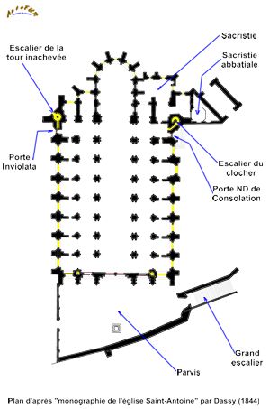
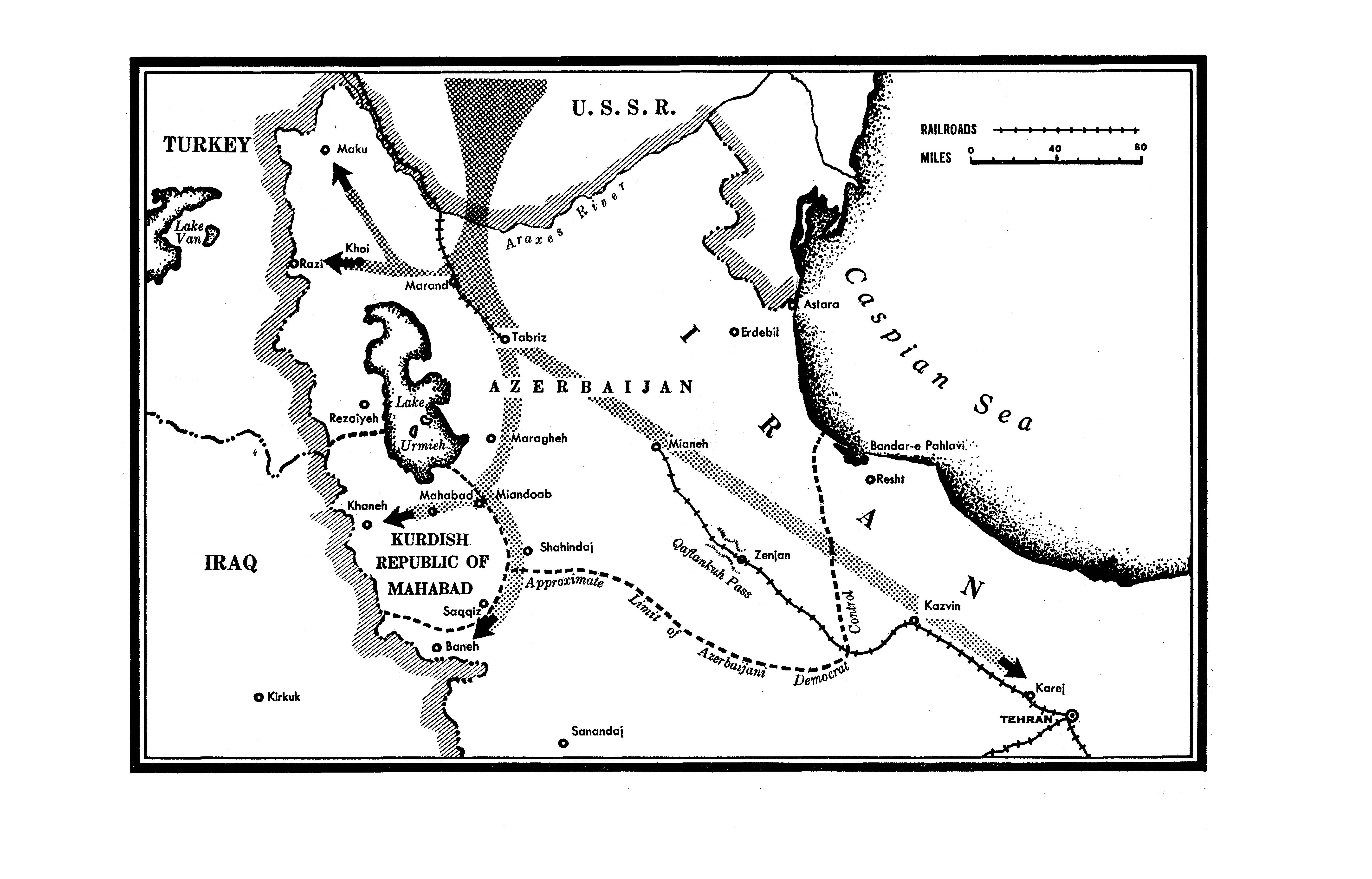
.svg)
.svg)
.svg)
.svg)
.svg)
.svg)
Article(s):The Wash and various others
- Request
- Please can a SVG version of this map please be created of the Wash that goes around the Lincolnshire and Norfolk coastlines, in the new SVG version can the places listed on the PNG map be included in the new map along with the river outlines of the Witham, Welland, Nene and Great Ouse and the county boundary of both Lincolnshire and Norfolk and also to add some further information could some of the features of the wash be included like “The Lynn Channel”the “Boston Deeps” and the “Lynn Deeps”. (MOTORAL1987 (talk) 12:52, 31 August 2023 (UTC))
- Graphist opinion(s)
![]() Request taken by --please ping me-- Goran tek-en (talk) 11:23, 19 February 2024 (UTC)
Request taken by --please ping me-- Goran tek-en (talk) 11:23, 19 February 2024 (UTC)
- @MOTORAL1987 You will have to give me information regarding The Lynn Channel, I can't find it? --please ping me-- Goran tek-en (talk) 18:34, 19 February 2024 (UTC)
- @MOTORAL1987 Now I need more info from you, don't forget the Lynn Channel.
- Do you want the areas Blue and Green like in this draft, not final just to show.
- You can see them here also, aren't they important for this area? --please ping me-- Goran tek-en (talk) 16:43, 20 February 2024 (UTC)
- @MOTORAL1987 Now I need more info from you, don't forget the Lynn Channel.
MOTORAL1987 I'm not getting any feedback from you so now I have uploaded what I have. If you want anything changed just ping me, thanks.
Now you can find it here file:The Wash England.svg.
- Please check all the information, also links for wikipedia, wikidata and structured data.
- If you are happy with this please put the code
"{{section re.solved|1=~~~~}}"(without the ".") on this request so it can be archived, thanks. Done --please ping me-- Goran tek-en (talk) 14:56, 28 February 2024 (UTC)
- Hello there, I am sorry I haven’t been logged in for a while, thank you so much for working on the new image it is fantastic and a missive improvement on the old one. The only things I can think off that would round off the map perfectly would be the following
1. Please add the towns of Hunstanton and Downham Market onto the map.
2. Can the villages of Fosdyke (can the area known as the Fosdyke Wash also be mentioned too),Long Sutton and Sutton Bridge also be added to the map as they are important reference points on the Wash.
3. Please also add the location of the royal estate of Sandringham also be added onto the map as well please.
4 Can Cambridgeshire be labelled on the map as it is currently unmarked and added into the legend. Otherwise thank you so much.
(MOTORAL1987 (talk) 14:51, 2 March 2024 (UTC))
- Done (MOTORAL1987 (talk) 16:50, 3 March 2024 (UTC))
- This section was archived on a request by: --please ping me-- Goran tek-en (talk) 17:31, 23 April 2024 (UTC)