Sameboat
| This talk page receives less attention from its user:Sameboat. Unless your message is directly related to Wikimedia Commons' operational affair, you may consider contacting Sameboat in English Wikipedia or Chinese Wikipedia. Thank you:) |
BS Icons
editHello,
would you please have a look at the policies, especially the part about new icons and the category? I would also appreciate if you could change the category of the icons you have already uploaded (to /experimental).
Regards, --MdE 22:45, 20 October 2007 (UTC)
Hi Sameboat,
concerning your edits to existing SVG image source code, as the images are used thousands of times, your co-authors would appreciate if you would use the Edit summary field to let others know what is the rationale behind your editing of the SVG source code. We see that you cut out comments, possibly superfluous XML attributes, but also the SVG title element recommended in the SVG specification[1], the XML header and the DOCTYPE declaration. With the last three, I am certain that they are useful when editing the source code with XML editors or SVG editors, especially when new versions of XML or SVG will come up. Regards, --dealerofsalvation 11:40, 21 October 2007 (UTC)
- Besides, Firefox can't display the icons without these header informations. Regards, --MdE 17:28, 21 October 2007 (UTC)
- I have also written an answer on my german talk page. --MdE 18:14, 21 October 2007 (UTC)
- Thanks for your answer you were posting at en:User talk:Dealerofsalvation#SVG edit issue. I suggest keeping the discussion thread here in place, so that others will be able to follow the discussion easily.
- So am I right that we have consensus on restoring the XML header, DOCTYPE and SVG title?
- What to do about the other attributes left out e.g. in Image:BSicon STR.svg? Are there any disadvantages with the original versions? Should we just restore the original versions, or should we create new versions? --dealerofsalvation 08:56, 22 October 2007 (UTC)
- Regarding the browsing issue, I am not against the reversion. Since you have mentioned, I tested with different browsers such as Firefox, IE, myIE and GreenBroswer. Firefox has the same result just as MdE. IE with Adobe SVG Viwer can render the graphic w/o header. Other 2 browsers, well, they do not render either versions or even show the codes. But they do render some other SVG files such as my recent work image:Hong_Kong_Railway_Route_Map_en.svg. Either way the browser preview does not prove to be satisfying. Again, if size (especially for SVG format) doesn't matter, do it. -- Sameboat - 同舟 09:45, 22 October 2007 (UTC)
- I'm about to :) --dealerofsalvation 14:18, 23 October 2007 (UTC)
- Regarding the browsing issue, I am not against the reversion. Since you have mentioned, I tested with different browsers such as Firefox, IE, myIE and GreenBroswer. Firefox has the same result just as MdE. IE with Adobe SVG Viwer can render the graphic w/o header. Other 2 browsers, well, they do not render either versions or even show the codes. But they do render some other SVG files such as my recent work image:Hong_Kong_Railway_Route_Map_en.svg. Either way the browser preview does not prove to be satisfying. Again, if size (especially for SVG format) doesn't matter, do it. -- Sameboat - 同舟 09:45, 22 October 2007 (UTC)
BS icons
editHello,
your icons (with the little arrows) are still in the normal category, but they should be in the experimental-category. Could you please correct that?
Regards, --MdE 11:57, 31 December 2007 (UTC)
Hi, there seems to be some disagreement about this icon. Can you please discuss the issues first on the image talk page before you make any more reverts? Thank you. --Tryphon (talk) 00:22, 24 February 2009 (UTC)
- Sorry for the missunderstanding last night, I was a bit tired. Today I made 24 new crossing icons involving high level tracks, please have a look at user:axpde/BSicons#crossings! Thank you axpdeHello! 15:46, 24 February 2009 (UTC)
TUSC token 05fdd6da9013af9e89854a0eac688cd3
editI am now proud owner of a TUSC account!
Your deletion request
editHi, I completed it at Commons:Deletion requests/File:BSicon uLUECKE.svg (mabe the previous DRD caused a problem). /Pieter Kuiper (talk) 21:31, 16 August 2009 (UTC)
BS icons III
editHi Sameboat,
nice deal with File:BSicon obsolete.svg, thanks alot for your support!
Concerning File:BSicon STRl.svg, I'd say this is another proper name for File:BSicon STRlf.svg (you know, I'd like to drop the 'f' and 'g'). How about "BSicon STRql.svg" instead to show this is a track across leading left ...?
CU axpdeHello! 23:10, 29 October 2009 (UTC)
Again, you did a good job on File:BSicon exINT.svg! Those INT icons are not my cup of tea, so good to see someones caring for those :-) axpdeHello! 13:33, 7 November 2009 (UTC)
Hi Sameboat,
sorry for not calling earlier. I have quit wikipedia two months ago due to big frustration in German wikipedia, and so far you seem to be the only one who noticed ...
I don't think file:BSicon STq.svg is a sensible name, BSicons are mainly about railroads, hence street icons should have a *longer* name than railroad icons, futhermore that name can easily be mistaken for file:BSicon STRq.svg ...
But at the moment wikipedia is not of my concern, have to do things much more important ... teaching kiddies ;-)
Best wishes, axpdeHello! – today incognito as 94.220.245.13 19:10, 26 February 2010 (UTC)
BS icons IV
editWhy does BSicon CONTr 20px|border face in different direction than exCONTr 20px|border? The same thing with CONTl and exCONTl. It is slightly annoying when making the route templates... :-) —Tve4 (talk) 10:28, 1 February 2010 (UTC)
- it's because noone has yet corrected it ... will be done some day! axpdeHello! 09:19, 24 April 2010 (UTC)
my apply for adminship
editHi Sameboat,
after pondering long about it I applied for adminship, I'd really like your support on Commons:Administrators/Requests/Axpde. Thanks axpdeHello! 09:18, 24 April 2010 (UTC)
Is my file correctly named
editHi, I just created File:BSicon kABZr+xr.svg - the shape and colours are exactly what I need, but have I given it the correct name? --Redrose64 (talk) 18:01, 27 August 2010 (UTC)
Hi Sameboat, do you still have an usage for this icon or is it obsolete? Regards axpdeHello! 09:47, 18 April 2011 (UTC)
- No already. -- Sameboat - 同舟 (talk) 06:32, 19 April 2011 (UTC)
- Sorry, no what? axpdeHello! 09:07, 19 April 2011 (UTC)
- Obsoleted. -- Sameboat - 同舟 (talk) 10:22, 22 April 2011 (UTC)
- Thanks for clarifying :) axpdeHello! 01:01, 23 April 2011 (UTC)
- Obsoleted. -- Sameboat - 同舟 (talk) 10:22, 22 April 2011 (UTC)
- Sorry, no what? axpdeHello! 09:07, 19 April 2011 (UTC)
BS icons V
editHello Sameboat,
Could you please describe "the graphic glitch generated by MediaWiki's SVG renderer" that you noticed? Just so that I (and others) won't upload broken files in future. Thanks. YLSS (talk) 11:04, 14 June 2013 (UTC)
COM:DR
editI made this edit to reflect your comments so that my original point doesn't get lost in semantics for those who join from this point forward. If you want to make some corresponding change or omission then I am fine with that as well. — C M B J 10:22, 16 June 2013 (UTC)
- I'm not changing my own comment, but it would be better if you
strikethan remove those words. -- Sameboat - 同舟 (talk) 10:42, 16 June 2013 (UTC)
Commons:WikiProject BSicon
editYou are invited to join Commons:WikiProject BSicon. YLSS (talk) 20:58, 21 July 2013 (UTC)
錄音
edit您好,請問您可唔可以錄個「雞」字 ? 198.105.111.86 12:36, 1 November 2013 (UTC)
Invitation to Participate on Talk:BSicon/Icon_geometry_and_SVG_code_neatness#Elevated_to_tunnel
editHi! May I invite you to put your inputs regarding Talk:BSicon/Icon_geometry_and_SVG_code_neatness#Elevated_to_tunnel as User:Useddenim seems to implement a new standard towards some icons that is different from the existing ones. For uniformity's sake I have opened a discussion on whether how to tackle this and what should prevail. Your useful input would be very much appreciated. Mabuhay! PhilippineRevolution (talk) 13:50, 28 December 2013 (UTC)
Moscow Metro map
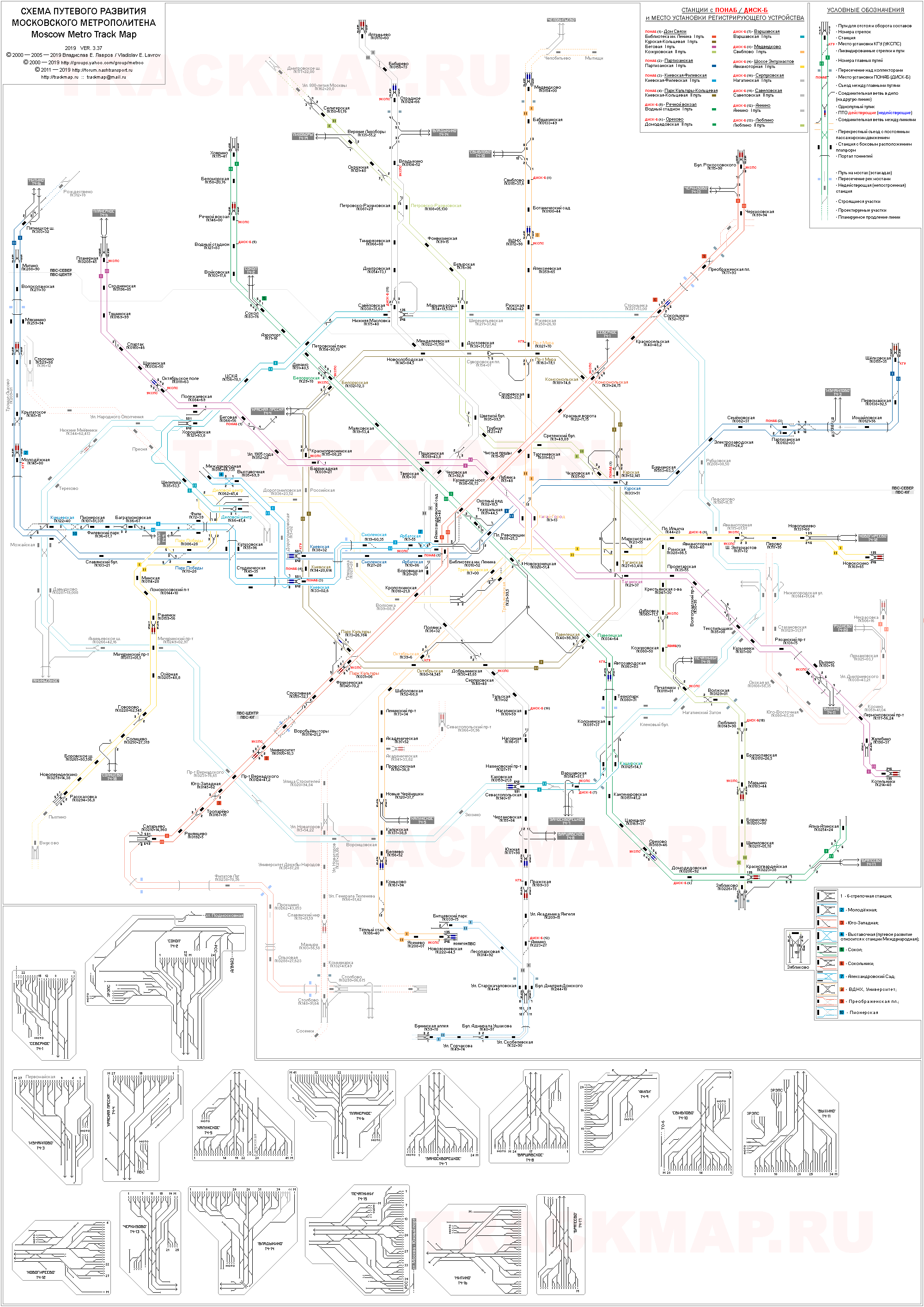
editHi, do I understand right that at File:Sameboat temp1.svg you placed the lines at crossings one above the other just like the tunnels cross IRL? Well done! I can only notice that APL crosses TKL and KRL most likely below them (see [2], 2nd scheme). I don't know why in Lebedev's new scheme it crossed KRL on top but TKL below it; but it is quite improbable, since both halls of Kitay-gorod are at the same level, and APL tunnel runs not very far to the north... YLSS (talk) 13:15, 30 December 2013 (UTC)
It is actually trickier to place TKL between the layer of APL/Line 2 and ZL/Line 3 because Line 3 crosses over Line 2 at Pl.Revolyutsy-Teatralnaya, also in his "version 2" map TKL is under APL. So the only thing I'm sure is that Lebedev is conscious of this particular detail, whether the idea belongs to him or the Transportation Department. However, I have a very very weak explanation: Line 3 is blue and Line 7 is purple, blue is visually darker than other color even with equal sum of RGB value, so Lebedev's arrangement of purple(paler)-blue(darker)-white(background) would create a better contrast of layering than blue-purple-white. Anyway this is just my silly speculation, nothing scholarly. -- Sameboat - 同舟 (talk) 16:36, 30 December 2013 (UTC)- I checked trackmap once again and it shows Line 6 and 7 are above Line 3, although there's no way I can verify its credibility. The funny thing is all 3 finalists (Lebedev, RIA and Ilya Birman) of 2012~2013 Moscow Metro map contest have line 6 under but line 7 over line 3. The reason for this common practice of all 3 finalists is due to the general layering order of these 3 lines is (from top to bottom) 7>3>(5)>6, ignoring the crossing near Kitay-gorod. If I want to make line 6 cross over line 3 near Kitay-gorod like line 7 does, it requires additional line 6 section over line 3 at that position. -- Sameboat - 同舟 (talk) 13:24, 2 January 2014 (UTC)
tABZ rework
editPlease have a look at Talk:BSicon/Icon geometry and SVG code neatness#Tunnel geometry on 90-degree curves. Let's use stroke-dasharray:49.09;stroke-dashoffset:24.5 for such curves. YLSS (talk) 15:28, 15 January 2014 (UTC)
- Oops. Sorry for ignoring that disucssion, I will fix it again. -- Sameboat - 同舟 (talk) 15:36, 15 January 2014 (UTC)
Hi again, I hope you don't consider me too rude for messing up like that with your uploads, sorry for that! Just the current naming scheme is already quite well established (even though it has it drawbacks), and switching to e.g. ABZglrq instead of ABZqr+r (or ABZqlr, as was originally proposed) would mean moving and replacing quite a lot of files. Not that I'm against it, but I don't want to do this (and currently a large part of this task is done by me); there are already 419+140 and more to be replaced. Also, I guess Tuválkin has infected me with excessive care for file histories (I have even added three requests at Commons:History merging and splitting/Requests, even though it is unlikely they will ever be answered), so I tried to preserve the older files (esp. those from 2006 etc). P.S. Great thanks for the uploads!! YLSS (talk) 07:55, 16 January 2014 (UTC)
- Don't worry, I'm not mad. However, if you're going to preserve Axp's original naming scheme of the ABZ/STR series (for whatever reason) I hope Circeus's naming scheme is maintained as redirect as a compromise at least. -- Sameboat - 同舟 (talk) 08:07, 16 January 2014 (UTC)
- Circeus's scheme was never actually implemented for junctions with a track across in the classic sets, only in "other colors", and I already undid that some time ago (redirects are impossible in this case as the names are swapped). For junctions with a track through, it does not differ from the current one, except for
 (
(ABZrf); for these, I also considered creating redirects (or even moving them), but this should be discussed elsewhere. YLSS (talk) 08:38, 16 January 2014 (UTC)
- Circeus's scheme was never actually implemented for junctions with a track across in the classic sets, only in "other colors", and I already undid that some time ago (redirects are impossible in this case as the names are swapped). For junctions with a track through, it does not differ from the current one, except for
Hold on for a sec with similar: (tKRW+xlr), they should be ![]() (
(tKRW+rxl), like ![]() (
(ABZ+rxl)... YLSS (talk) 09:43, 17 January 2014 (UTC)
- I hold that belief because the naming scheme is used in en:Wikipedia:Route diagram template/Catalog of pictograms/krw, but I think there is little ambiguity between the suffices xlr or rxl because they do not posses the prefix x. -- Sameboat - 同舟 (talk) 09:48, 17 January 2014 (UTC)
- I've already updates that one ;) We should still use "rxl" in such cases for consistency with e.g.
 (
(kKRZ+rxl) vs. (
(kKRZ+xlr). Of course, (
(exKRW+lr) should better be as it is, and notKRW+xlr, but still...YLSS (talk) 09:58, 17 January 2014 (UTC)- I've requested for renaming of SHI4q's xlr icons to rxl. I don't think leaving the xlr redirect is harmful as long as it doesn't conflict with other SHI4q icons (
 (
(eSHI4glrq)? I don't think so), but wouldn't be upset if you insist deleting those xlr redirects. -- Sameboat - 同舟 (talk) 08:36, 18 January 2014 (UTC)
- I've requested for renaming of SHI4q's xlr icons to rxl. I don't think leaving the xlr redirect is harmful as long as it doesn't conflict with other SHI4q icons (
- I've already updates that one ;) We should still use "rxl" in such cases for consistency with e.g.
exCONTgq
editFYI: Special:GlobalUsage/BSicon_exhCONTr.svg. YLSS (talk) 12:04, 5 March 2014 (UTC)
- I planned to create redirect once the image was deleted. But this will not happen again because I have been granted file mover right, finally. -- Sameboat - 同舟 (talk) 14:19, 5 March 2014 (UTC)
- Congratulations!! YLSS (talk) 14:51, 5 March 2014 (UTC)
Notification about possible deletion
edit
|
Some contents have been listed at Commons:Deletion requests so that the community can discuss whether they should be kept or not. We would appreciate it if you could go to voice your opinion about this at their entry.
If you created these pages, please note that the fact that they have been proposed for deletion does not necessarily mean that we do not value your kind contribution. It simply means that one person believes that there is some specific problem with them, such as a copyright issue. Please see Commons:But it's my own work! for a guide on how to address these issues. |
Hi Sameboat, you edited a quite lot of localizing Created with/ templates, and other templates using them. IMHO your changes are suboptimal. Trying to set a width default there will not do any harm, but it is of no use when the other templates are maintained. The default for missing values should be set in the last template, unfortunately it is protected.
I tried to explain the current situation and the solution for the current problems. Most central templates are protected, so an admin is needed to edit them. Regards, sarang♥사랑 09:08, 5 April 2014 (UTC)
File:MediaWiki_SVG_fonts.svg / File:MediaWiki SVG font list.svg
editHallo Sameboat, could you please made an really update to what is up to date in meta:SVG fonts (it seems to me you have not quite seen)? Greedings -- Perhelion (talk) 09:01, 29 April 2014 (UTC)
- @Perhelion: The update is merely to demonstrate the Japanese fonts (Kochi/Takao/VL) which were previously incorrectly installed (thus fell back to DejaVu Sans automatically) but has been fixed recently. (Bugzilla: 64002) -- Sameboat - 同舟 (talk) 09:32, 29 April 2014 (UTC)
Hmm, only now I noticed that File:Moscow map MKAD metro line.svg, which is used in two dozen pages in en.wp (partly introduced by me), is not maintained any more, while you rather update File:Moscow map MKAD metro line guided.svg. Is there any principal difference between these files? If not, how about like this: renaming File:Moscow map MKAD metro line.svg to some other title; re-pointing the redirect to File:Moscow map MKAD metro line guided.svg; and asking some admin to split the top three versions of the older file and merging them as previous versions of the newer file? YLSS (talk) 13:47, 1 September 2014 (UTC)
- All in all, redirect is a good idea. Now some history about these 2 images: File:Moscow map MKAD metro line guided.svg serves as the base for producing File:MM L1 - Sokolnicheskaya.png series maps for Moscow Metro line articles. I stopped maintaining File:Moscow map MKAD metro line.svg because Ворот93 (no longer active for 1 year) seemingly was experimenting between different approaches to apply location map in English Moscow Metro station articles which the result shows that he was not quite lean on overlapping the transparent line map over the street map, possibly due to the clutter it produces (c.f. Kuntsevskaya). So I didn't bother to ask or update it anymore if the method is not supported by another user. Now I think about it, the overlapping by the line map might look clearer if the base street map is in grey tone instead of colored. -- Sameboat - 同舟 (talk) 15:15, 1 September 2014 (UTC)
- OMG... Just now I clicked on the previous version of File:Moscow map MKAD metro line guided.svg to see what changes you made, and all of a sudden there's a background! In all the previous versions! MediaWiki fails to load it. Now I understand what you wrote above... But don't understand your intentions with them... YLSS (talk) 16:54, 1 September 2014 (UTC)
- There is report that linking external raster image in the SVG is not properly supported by RSVG, the rendering library used by Wikimedia. Not only the linked image will not be loaded, the whole SVG may corrupt in some case, so I decided not to use the "guided" version directly but only a source for producing the monotone PNG images. Sameboat - 同舟 (talk) 22:42, 1 September 2014 (UTC)
- P.S. I commented the linking to file:Moscow metro general plan 2025.jpg in the "guided" version in the latest revision because the uploader would not allow me to upload for XML error. -- Sameboat - 同舟 (talk) 23:24, 1 September 2014 (UTC)
- That one is quite outdated... Anyway, in a couple of years we'll need some other background, when the lines to Nekrasovka, Rasskazovka and Kommunarka open (hm, I didn't notice before that they sound so good together!). YLSS (talk) 08:22, 2 September 2014 (UTC)
- How does this sound to you? YLSS (talk) 08:45, 2 September 2014 (UTC)
- No. Ворот93 and I agreed to abandon the initial 2 versions of File:Moscow map MKAD metro line.svg because that raw SVG data of OpenStreetMap is nearly impossible to be edited manually. So in the station articles, we overlap the transparent line map over File:Moscow map MKAD.svg. I think logically we can delete File:Moscow map MKAD metro line.svg to make way for File:Moscow map MKAD metro line guided.svg to be moved over because the latter is chronologically more updated. -- Sameboat - 同舟 (talk) 09:02, 2 September 2014 (UTC)
- OK; could you then nominate it for deletion? So that I don't mis-explain anything... YLSS (talk) 10:27, 2 September 2014 (UTC)
- @YLSS: so some admin refuse to delete the old one because it's still in use, but I can just overwrite with the "guided" version which doesn't make much difference. -- Sameboat - 同舟 (talk) 22:29, 10 September 2014 (UTC)
- Yeah, some admins should be explicitly told what to do: "please delete and move"; but even then there's no guarantee that they'll do nothing but quote a couple of rules to you... Anyway, thanks for all those edits at en.wp! YLSS (talk) 17:32, 11 September 2014 (UTC)
- @YLSS: so some admin refuse to delete the old one because it's still in use, but I can just overwrite with the "guided" version which doesn't make much difference. -- Sameboat - 同舟 (talk) 22:29, 10 September 2014 (UTC)
- OK; could you then nominate it for deletion? So that I don't mis-explain anything... YLSS (talk) 10:27, 2 September 2014 (UTC)
- No. Ворот93 and I agreed to abandon the initial 2 versions of File:Moscow map MKAD metro line.svg because that raw SVG data of OpenStreetMap is nearly impossible to be edited manually. So in the station articles, we overlap the transparent line map over File:Moscow map MKAD.svg. I think logically we can delete File:Moscow map MKAD metro line.svg to make way for File:Moscow map MKAD metro line guided.svg to be moved over because the latter is chronologically more updated. -- Sameboat - 同舟 (talk) 09:02, 2 September 2014 (UTC)
- OMG... Just now I clicked on the previous version of File:Moscow map MKAD metro line guided.svg to see what changes you made, and all of a sudden there's a background! In all the previous versions! MediaWiki fails to load it. Now I understand what you wrote above... But don't understand your intentions with them... YLSS (talk) 16:54, 1 September 2014 (UTC)
London Underground Overground DLR Crossrail map
edit
Just wanted to say ... I have just noticed your London Underground Overground DLR Crossrail map and it is brilliant. Great piece of work, must have taken you ages. Well done, excellent contribution to Wikipedia! Cnbrb (talk) 14:41, 11 October 2014 (UTC)
- @Cnbrb: Thank you. Hope this inspires you to join the fun of making SVG map. -- Sameboat - 同舟 (talk) 12:08, 12 October 2014 (UTC)
- ...and your London map has been the subject of an article on CityMetric here. Congrats and thanks for your work on this. Jane023 (talk) 15:24, 2 June 2015 (UTC)
圣彼得堡地铁线路图简体中文版
edit刚才在看线路图的时候发现了3号线的站名2处笔误:
- Елизаровская站的译名混入了一个繁体的“羅”字了。
- Ломоносовская站的名字因为是来自科学家Ломоносов,中国大陆地区通常译作“罗蒙诺索夫”,因此用“罗”比“洛”更适当。
其他关于译名的问题,等明年5号线南延段开通时再重新考究和整理吧。 Aleksejevski (talk) 06:41, 31 May 2015 (UTC)
London Underground map - article on citymetric.com
editIn case you weren't already aware, i thought you'd like to know about the following article on citymetric.com: [3]. Julianhall (talk) 11:07, 2 June 2015 (UTC)
- It's been picked up by The Independent: A Tube map of the London Underground that's far more useful than the 'official' one - Friday 05 June 2015. Well done! :-) Cnbrb (talk) 15:22, 5 June 2015 (UTC)
A barnstar for you!
edit
|
The Technical Barnstar |
| Please accept this technical barnstar for all the nice maps you have created using SVG. Congratulations SameBoat ! Hashar (talk) 10:26, 23 June 2015 (UTC) |
Regarding File:West Coast Main Line service pattern diagram.svg
editI notice you redrew the above map recently. Unfortunately the map it was based on has become out of date and the services described have changed considerably since 2010 when the original was drawn. The current normal weekday service (as of May 2015) is as follows:
Virgin Trains
edit- (dep. 03 mins) London–Rugby–Coventry–B'ham Intl–Birmingham
- (dep. 23 mins) London–Watford–Coventry–B'ham Intl–Birmingham
- (dep. 43 mins) London–Milton Keynes–Coventry–B'ham Intl–Birmingham–Sandwell–Wolverhampton–Crewe–Warrington–Wigan–Preston–Lancaster–Oxenholme/Penrith (alternating)–Carlisle–Glasgow/Haymarket–Edinburgh (alternating)
- (dep. 10 mins) London–Milton Keynes–Crewe–Chester (some continuing to Bangor/Holyhead)
- (dep. 07 mins) London–Stafford–Crewe–Runcorn–Liverpool
- (dep. 30 mins) London–Warrington–Wigan–Preston–Lancaster–Oxenholme/Penrith (alternating)–Carlisle–Glasgow
- (dep. 00 mins) London–Stoke–Macclesfield–Stockport–Manchester
- (dep. 20 mins) London–Milton Keynes–Stoke–Stockport–Manchester
- (dep. 40 mins) London–Crewe–Wilmslow–Stockport–Manchester
London Midland
edit- (dep. 13 mins) London–Leighton–Bletchley–Milton Keynes–Wolverton–Northampton–Long Buckby–Rugby–Coventry–Tile Hill–Hampton–B'ham Intl–Marston Green–Birmingham
- (dep. 49 mins) London–Watford–Milton Keynes–Northampton–Long Buckby–Rugby–Coventry–Canley–Tile Hill–Berkswell–B'ham Intl–Marston Green–Lea Hall–Birmingham
- (dep. 54 mins) London–Watford–Hemel–Berkhamsted–Leighton–Bletchley–Milton Keynes–Wolverton–Northampton
- (dep. 25 mins) Northampton–Long Buckby–Rugby–Coventry–Canley–Tile Hill–Berkswell–Hampton–B'ham Intl–Marston Green–Birmingham (NB: in the southbound direction the above two services run as one)
- (dep. 46 mins) London–Milton Keynes–Rugby–Nuneaton–Atherstone–Tamworth–Lichfield–Rugeley–Stafford–Stone–Stoke–Kidsgrove–Alsager–Crewe
- (dep. 24 mins) London–Watford–Hemel–Berkhamsted–Tring–Cheddington–Leighton–Bletchley–Milton Keynes
- (dep. 04 mins) London–Wembley Central (limited)–Harrow–Bushey–Watford–Kings Langley–Apsley–Hemel–Berkhamsted–Tring
- (dep. 34 mins) London–Harrow–Bushey–Watford–Kings Langley–Apsley–Hemel–Berkhamsted–Tring
- (dep. 01 mins) Birmingham–Smethwick GB–Wolverhampton–Stafford–Crewe–Winsford–Hartford–Acton Bridge (limited service)–Runcorn–Liv S Pkwy–Liverpool
- (dep. 36 mins) Birmingham–Coseley–Wolverhampton–Penkridge–Stafford–Crewe–Runcorn–Liv S Pkwy–Liverpool
Transpennine Express
edit- (dep. 00 mins) Manchester Airport–Manchester Picc–Manchester Ox Rd–Wigan–Preston–Lancaster–Oxenholme–Penrith–Carlisle–Lockerbie–Glasgow/Haymarket–Edinburgh (alternating)
- (limited service via Bolton and Chorley instead of via Wigan)
—109.147.41.151 13:35, 2 July 2015 (UTC)
Crossrail map in German
editHi Sameboat
Two years ago you remade the map of London's Crossrail system (File:CrossrailLine1Map.svg). The same map in German (File:CrossrailLine1Map-de.svg) lacks two stations at the western end (Twyford, Reading). Could you please add them? Thanks a lot. --Voyager (talk) 09:05, 28 September 2015 (UTC)
- Work in progress: The English version is terribly geographically inaccurate, so I have to redo the whole thing from scratch using geographical data from OpenStreetMap. The German version will be updated after the English version's revision. -- Sameboat - 同舟 (talk · contri.) 13:22, 28 September 2015 (UTC)
- @Voyager: I've finished updating file:CrossrailLine1Map.svg, but I'm afraid I've included few more English description text in the map which I don't know how to translate them into German. Apparently I can't resort to Google Translates, so you need to do the translation for me. These are:
"London fare zone inapplicable" (stations not assigned into Transport for London railway fare zonal system)
"km/mi" (kilometre/mile)
"Heathrow Airport special fares apply" (simply put, charge more than the Underground)
"Central London"
"Special fares apply" (Shenfield)
If you don't want to wait, just open the English version in Notepad and translate all the text within the <text> tags and preview the SVG file in your browser and SVG Check before upload. -- Sameboat - 同舟 (talk · contri.) 16:08, 28 September 2015 (UTC)
- Here's the translation:
- "London fare zone inapplicable" = "Londoner Tarifzonen nicht anwendbar"
- "km/mi" = "km/Meilen"
- "Heathrow Airport special fares apply" = "Sondertarif für Flughafen Heathrow"
- "Central London" = "Zentral-London"
- "Special fares apply" = "Sondertarif"
- Here's the translation:
- --Voyager (talk) 18:34, 28 September 2015 (UTC)
- @Voyager: Done, but you may check carefully of "Meilen", "nach offiziellen Plänen vom September 2015" and "Themse" if I got them grammatically correctly in the map. -- Sameboat - 同舟 (talk · contri.) 02:09, 29 September 2015 (UTC)
- Everything is OK. Thank you very much. --Voyager (talk) 06:14, 29 September 2015 (UTC)
- @Voyager: Done, but you may check carefully of "Meilen", "nach offiziellen Plänen vom September 2015" and "Themse" if I got them grammatically correctly in the map. -- Sameboat - 同舟 (talk · contri.) 02:09, 29 September 2015 (UTC)
- --Voyager (talk) 18:34, 28 September 2015 (UTC)
Moscow Metro map in German
editDear Sameboat,
I've transliterated the cyrillic Moscow Metro map into German (File:Moscow metro map de sb.svg). Thanks for your nice work. It would be great if could update it together with the other versions.
Cheers,--Kopiersperre (talk) 09:30, 20 October 2015 (UTC)
Circular Overground
editHi there. File:London Overground as a circle.svg is superb! Thank you. One thing, though - I can't get over the huge bend between Walthamstow Central and Wood Street in the northeast corner - which is where I live. In reality it's almost a straight line between the two. Do you think that you could soften it somehow?
Best wishes, — Scott • talk 15:43, 24 November 2015 (UTC)
Moscow Metro schematic maps created by Shadiac
editHi!
About 3 or so years ago, me, going by the username Shadiac, created maps of Moscow Metro to use in Russian WP articles, highlighting each line a red color. Yesterday I've added more material to these maps, and thought that I could use them in an open-Wiki project community called "our transport" (forum.nashtransport.ru). I got their agreement for this, but what I want to know is if you agree for me to further modify those maps and use them on their Wiki. Because you did a lot of updating on them, so I just want to be sure we're clear on this.
Thanks, --Whydoesitfeelsogood (talk) 10:55, 16 February 2016 (UTC)
- You do not even need my permission because of the Creative Commons Attribution-Share Alike license. You only need to add the link to Wikimedia Commons image description page, the same license statements and all contributors' names in the image description page of Nashtransport wiki. -- Sameboat - 同舟 (talk · contri.) 14:21, 16 February 2016 (UTC)
- Kudos for the answer. Listen, could you please tell me what perspective map you've used back then for the background? I'm trying to get a hold of that version. Thanks again, --Whydoesitfeelsogood (talk) 05:08, 19 February 2016 (UTC)
- File:Moscow_metro_general_plan_2025.jpg in ru:Программа развития Московского метрополитена. Wonder if you knew about this article and helped edit it. -- Sameboat - 同舟 (talk · contri.) 07:32, 19 February 2016 (UTC)
- Kudos for the answer. Listen, could you please tell me what perspective map you've used back then for the background? I'm trying to get a hold of that version. Thanks again, --Whydoesitfeelsogood (talk) 05:08, 19 February 2016 (UTC)
Swedish vowels
editAll done, thanks again. Now all that's left is to recreate File:Czytanie.png (which is full of mistakes, AFAICS)... Mr KEBAB (talk) 16:46, 1 May 2016 (UTC)
File:Combotrans.svg and File:Combotrans.png
edit
Your versions are probably better, but they may not be what was intended by the original uploaders (Pschemp etc.) AnonMoos (talk) 03:59, 2 May 2016 (UTC)
File:Moscow metro map zh-hant sb.svg
editPlease Change the traditional Chinese of Ploshchad Revolyutsii station to 「革命廣場」. It will be so nice if it is corrected.—An Macanese 10:18, 15 August 2016 (UTC)
- @An Macanese: Fixed. Thx for notice. -- Sameboat - 同舟 (talk · contri.) 11:35, 15 August 2016 (UTC)
Thanks for your help. Now here is another topic relates to all Moscow Metro maps. Firstly, Line 10 was extended north therefore I kindly beg you update those maps. Next, you have made a map with line 14 but how about line 13?—An Macanese 20:01, 18 September 2016 (UTC)
- @An Macanese: Because of maintenance difficulty and my shift of attention, I will only update file:Moscow metro ring railway map en sb future.svg and file:Moscow metro ring railway map ru sb future.svg from now on. -- Sameboat - 同舟 (talk · contri.) 04:00, 19 September 2016 (UTC)
Hi there. For some reason thumbnails for the above image fail to generate following your edit (see e.g in en:List of counties in Oregon and File History section on the file page). Would you be able to fix? Thanks, Delta 51 (talk) 19:26, 24 August 2016 (UTC)
- @Delta 51: No. This is Wikimedia server load issue and the only solution is to avoid the 120px thumbnail altogether and use different width instead. -- Sameboat - 同舟 (talk · contri.) 22:34, 24 August 2016 (UTC)
3 new metro stations opened in Moscow
editHello. I feel bound to tell you that today the Lyublinsko-Dmitrovskaya (lime) line of Moscow Metro has been extended by 3 new stations, namely Butyrskaya, Fonvizinskaya & Petrovsko-Razumovskaya (north of the Ring Line). Here is an aggregated selection of Russian news on this event (sorry, so far there seems to be no news of this in English). Please consider updating all of your Moscow Metro maps. --213.87.129.229 09:49, 16 September 2016 (UTC)
- Hello. Could you please reply? Sorry, I can't update your maps myself as I'm very bad at graphics editing. (P. S. Here's an English article about the extension). --213.87.159.93 12:14, 24 December 2016 (UTC)
- I have already stop updating those versions. Please just use the one with Central Circle and future plans: File:Moscow metro ring railway map ru sb future.svg. -- Sameboat - 同舟 (talk · contri.) 06:40, 25 December 2016 (UTC)
A BSicon
editI've tried to make a junction formation (lhSTR-L+1+c2) from (lhSTR-L+1) and (lhSTR-L+c2), but had to resort to using Inkscape's path to area function. Is there a less cluttery way of making such an icon? Jc86035 (talk) Use {{ping|Jc86035}}
to reply to me 15:46, 5 November 2016 (UTC)
- I am still in London and can only use my iPhone to access the internet which does not support opening SVG/XML raw code natively. You may paste the path data of all icons if you want my assistance immediately. I will try to figure out a better way to combine those path data. -- Sameboat - 同舟 (talk · contri.) 16:50, 5 November 2016 (UTC)
- Never mind, brain fart. I realised one could just use background masking like usual.
 Jc86035 (talk) Use {{ping|Jc86035}}
to reply to me 02:54, 6 November 2016 (UTC)
- Never mind, brain fart. I realised one could just use background masking like usual.
I see you edited the article on Help:Illustrator recently— I am so glad that anyone even noticed that I wrote it! So here's my "thanks" for having noticed! Now, as for the change you made: you made the heading "Text Anchor: alignment" into an actual anchor template. This doesn't change the flow of the wording, of course, but neither is it what I meant by my use of the word "Anchor" here. In Illustrator, "Anchors" are places within an image to which a path or a stroke or text is somehow aligned— this is completely unrelated to the Commons template {{Anchor}}. BUT, it is possible that you are intending to anchor (in Commons terms) the "text anchor" paragraph so that it can be found by a link in some other Commons article— if this is the case, then it needs to be preserved! But if you only mistook my use of the word "Anchor" for the Commons template "Anchor", then we have a mixup. I suspect that is what we actually have. Am I wrong?? KDS4444 (talk) 07:44, 15 November 2016 (UTC)
- @KDS4444: It was an unintended pun. {{Anchor}} is indeed used for aiding internal linking because of the parentheses in the section title which could prevent jumping to the target section. -- Sameboat - 同舟 (talk · contri.) 07:48, 15 November 2016 (UTC)
A brownie for you!
edit| For your help at the map workshop - Pizza1016 (talk) 08:53, 21 November 2016 (UTC) |
|
|
File:Hong Kong Railway Route Map raw.png has been listed at Commons:Deletion requests so that the community can discuss whether it should be kept or not. We would appreciate it if you could go to voice your opinion about this at its entry.
If you created this file, please note that the fact that it has been proposed for deletion does not necessarily mean that we do not value your kind contribution. It simply means that one person believes that there is some specific problem with it, such as a copyright issue. Please see Commons:But it's my own work! for a guide on how to address these issues. |
to reply to me 13:35, 31 December 2016 (UTC)
Tube Map...
edit
Commons should now support the Free-ism implementation of Johnston Sans someone made and called Railway Sans [[4]]. Please consider looking to using that Font when you next update the map. ShakespeareFan00 (talk) 17:35, 23 January 2017 (UTC)
- @ShakespeareFan00: Have you tested if it is already usable on Wikimedia server? Because when I define the font-family as "RailwayRegular" it falls back to DejaVu Sans. -- Sameboat - 同舟 (talk · contri.) 23:51, 23 January 2017 (UTC)
- Hmm - Your sample doesn't render in RailwayRegular for me despite me having it installed locally. Something odd is happening here. ShakespeareFan00 (talk) 10:04, 24 January 2017 (UTC)
- The font name appears to be "Railway" without the regular suffix, according to the Font Control panel. This maybe why it isn't rendering. ? ShakespeareFan00 (talk) 10:06, 24 January 2017 (UTC)
- https://github.com/GregFleming/Railway-Sans appears to be the Github for this, maybe ask someone at Graphic Lab to "fix" the font metadata? ShakespeareFan00 (talk) 10:11, 24 January 2017 (UTC)
- Changing that worked, but the svgparser on Mediawiki seems to have a major issue with multi-line text, exported from Inkscape. :( ShakespeareFan00 (talk) 10:20, 24 January 2017 (UTC)
Seems the font isn't installed. So forget what I said at the start of the thread. ShakespeareFan00 (talk) 19:34, 24 January 2017 (UTC)
Jerusalem Light Rail
editHey. I was wondering if you might want to create a a map for the Jerusalem Light Rail. Here is a link to a map in hebrew and another map. Thanks. Hope you decide to create it.--Mikey641 (talk) 22:51, 26 January 2017 (UTC)
- @Mikey641: First thought about it. The current state of having only 1 line in operation means the demand of a dedicated "topological diagram" for the system is pretty low. The inclusion of future blue and green lines helps, but lacking an English-Hebrew stations list can be extremely tricky for me to ever begin working on it (keep in mind I don't understand Hebrew language at all), because a bilingual map is more helpful. All in all I encourage fellow Wikimedians to try making a true SVG rail map in Notepad++ on your own, using the tips, SVG template/codes in my user page and file:Israel Railway map Hebrew English sb.svg as your bases to kick-start. I can help during the process after most (better all) Hebrew-English station labels are roughly in place. -- Sameboat - 同舟 (talk · contri.) 04:38, 13 February 2017 (UTC)
Moscow Metro map
editCan you please update File:Moscow metro ring railway map en sb future.svg to add the projected expansion of the Sokolnicheskaya Line (1) from Salaryevo to Stolbovo. Can you also add the monorail to File:Moscow metro map including line 14.svg. --2607:FEA8:559F:FD61:3017:5C60:2633:8A99 04:29, 30 January 2017 (UTC)
 Done -- Sameboat - 同舟 (talk · contri.) 10:42, 30 January 2017 (UTC)
|
|
File:BSicon uCPICqd.svg has been listed at Commons:Deletion requests so that the community can discuss whether it should be kept or not. We would appreciate it if you could go to voice your opinion about this at its entry.
If you created this file, please note that the fact that it has been proposed for deletion does not necessarily mean that we do not value your kind contribution. It simply means that one person believes that there is some specific problem with it, such as a copyright issue. Please see Commons:But it's my own work! for a guide on how to address these issues. |
to reply to me 16:22, 3 March 2017 (UTC)
Moscow map MKAD metro line guided.svg
edit
Hello, I just updated Moscow map MKAD metro line guided with extensions of lines 8A and 10. Hope it was ok! I have so much of use of that svg, really good job you have put into that file --Inteloutside2 (talk) 19:56, 21 March 2017 (UTC)
|
|
File:BSicon STq.svg has been listed at Commons:Deletion requests so that the community can discuss whether it should be kept or not. We would appreciate it if you could go to voice your opinion about this at its entry.
If you created this file, please note that the fact that it has been proposed for deletion does not necessarily mean that we do not value your kind contribution. It simply means that one person believes that there is some specific problem with it, such as a copyright issue. Please see Commons:But it's my own work! for a guide on how to address these issues. |
to reply to me 14:34, 3 April 2017 (UTC)
|
|
File:BSicon sameboat005.svg has been listed at Commons:Deletion requests so that the community can discuss whether it should be kept or not. We would appreciate it if you could go to voice your opinion about this at its entry.
If you created this file, please note that the fact that it has been proposed for deletion does not necessarily mean that we do not value your kind contribution. It simply means that one person believes that there is some specific problem with it, such as a copyright issue. Please see Commons:But it's my own work! for a guide on how to address these issues. |
|
|
File:BSicon sameboat004.svg has been listed at Commons:Deletion requests so that the community can discuss whether it should be kept or not. We would appreciate it if you could go to voice your opinion about this at its entry.
If you created this file, please note that the fact that it has been proposed for deletion does not necessarily mean that we do not value your kind contribution. It simply means that one person believes that there is some specific problem with it, such as a copyright issue. Please see Commons:But it's my own work! for a guide on how to address these issues. |
|
|
File:BSicon sameboat003.svg has been listed at Commons:Deletion requests so that the community can discuss whether it should be kept or not. We would appreciate it if you could go to voice your opinion about this at its entry.
If you created this file, please note that the fact that it has been proposed for deletion does not necessarily mean that we do not value your kind contribution. It simply means that one person believes that there is some specific problem with it, such as a copyright issue. Please see Commons:But it's my own work! for a guide on how to address these issues. |
|
|
File:BSicon sameboat002.svg has been listed at Commons:Deletion requests so that the community can discuss whether it should be kept or not. We would appreciate it if you could go to voice your opinion about this at its entry.
If you created this file, please note that the fact that it has been proposed for deletion does not necessarily mean that we do not value your kind contribution. It simply means that one person believes that there is some specific problem with it, such as a copyright issue. Please see Commons:But it's my own work! for a guide on how to address these issues. |
|
|
File:BSicon sameboat001.svg has been listed at Commons:Deletion requests so that the community can discuss whether it should be kept or not. We would appreciate it if you could go to voice your opinion about this at its entry.
If you created this file, please note that the fact that it has been proposed for deletion does not necessarily mean that we do not value your kind contribution. It simply means that one person believes that there is some specific problem with it, such as a copyright issue. Please see Commons:But it's my own work! for a guide on how to address these issues. |
Notification about possible deletion
edit|
|
Some contents have been listed at Commons:Deletion requests so that the community can discuss whether they should be kept or not. We would appreciate it if you could go to voice your opinion about this at their entry.
If you created these pages, please note that the fact that they have been proposed for deletion does not necessarily mean that we do not value your kind contribution. It simply means that one person believes that there is some specific problem with them, such as a copyright issue. Please see Commons:But it's my own work! for a guide on how to address these issues. |
Affected:
Yours sincerely, ShakespeareFan00 (talk) 11:28, 22 May 2017 (UTC)
London Tube Map -Crossrail Terminal 5
editHi, I was wondering if you could update your London Rail Services map to include the newly planned Crossrail extension to Heathrow Terminal 5 to open in December 2019? Source: https://www.ianvisits.co.uk/blog/2017/07/04/elizabeth-line-gets-an-extension-to-heathrow-terminal-5/ LukasMaps (talk) 20:16, 5 July 2017 (UTC)
- @LukasMaps: Thanks for the notice.
I would wait slightly longer until TfL has made official announcement of this extended service.Seems to be reported by quite many press already. -- Sameboat - 同舟 (talk · contri.) 23:26, 5 July 2017 (UTC)
Notification about possible deletion
edit|
|
Some contents have been listed at Commons:Deletion requests so that the community can discuss whether they should be kept or not. We would appreciate it if you could go to voice your opinion about this at their entry.
If you created these pages, please note that the fact that they have been proposed for deletion does not necessarily mean that we do not value your kind contribution. It simply means that one person believes that there is some specific problem with them, such as a copyright issue. Please see Commons:But it's my own work! for a guide on how to address these issues. |
Affected:
And also:
- File:BSicon extSTRr.svg
- File:BSicon tSTRl.svg
- File:BSicon tSTRr.svg
- File:BSicon uextSTRl.svg
- File:BSicon uextSTRr.svg
- File:BSicon utSTRl.svg
- File:BSicon utSTRr.svg
Yours sincerely, Jc86035 (talk) 11:32, 28 August 2017 (UTC)
Notification about possible deletion
edit|
|
Some contents have been listed at Commons:Deletion requests so that the community can discuss whether they should be kept or not. We would appreciate it if you could go to voice your opinion about this at their entry.
If you created these pages, please note that the fact that they have been proposed for deletion does not necessarily mean that we do not value your kind contribution. It simply means that one person believes that there is some specific problem with them, such as a copyright issue. Please see Commons:But it's my own work! for a guide on how to address these issues. |
Affected:
And also:
- File:BSicon exSTRr.svg
- File:BSicon STRl.svg
- File:BSicon STRr.svg
- File:BSicon uexSTRl.svg
- File:BSicon uexSTRr.svg
- File:BSicon uSTRl.svg
- File:BSicon uSTRr.svg
Yours sincerely, Jc86035 (talk) 15:08, 4 September 2017 (UTC)
Moscow metro maps
editThanks for all you work on the Moscow Metro maps!
- Locator map: File:Moscow metro map including line 14.svg - this file has MKAD (good for orientation) but no stations (good for locator maps)
- Could you add the Third Interchange Counter (11) as dotted line? The SVG is used on future stations in enWP, e.g. en:Lefortovo (Moscow Metro) and all current stations. The dotted line then can be converted each time a section opens.
- Standalone map: File:Moscow metro map geo en - inc third interchange contour.svg - this has stations and station names (good for better understanding)
- Could you add the MCC ring (14), 8A and other lines, constructed or in planning? Maybe it would be the easiest for maintenance to update File:Moscow metro map geo en.svg and add all lines under construction there.
80.171.195.151 20:39, 7 December 2017 (UTC)
Khovrino opened.
- File_talk:Moscow_metro_map_including_line_14.svg#Green_line - done, thank you. 85.181.32.90 21:02, 4 January 2018 (UTC)
- File_talk:Moscow_metro_ring_railway_map_en_sb_future.svg#Green_line - done, thank you. 85.181.32.90 21:02, 4 January 2018 (UTC)
- File_talk:Moscow_metro_map_geo_en_-_inc_third_interchange_contour.svg#Green_line
77.179.91.93 02:25, 1 January 2018 (UTC)
请教关于BSicon的命名
edit你好,我在 Commons:WikiProject_BSicon 里看到你。想请教一个命名问题。
我打算制作「复合交分道岔」的 BSicon(一种既可以是 KRZ,又可以是两个 ABZ 组合在一起的道岔,不知道香港是不是这种叫法)。现在我的做法是三个图标组合在一起:KRZ3+1!~ABZg+1!~ABZg3。我想将它们做成一个图标以方便作图,但我对图标的命名规则不是很熟悉,不知道你是否可以给点建议呢?
XiNGRZ (talk) 08:23, 7 February 2018 (UTC)
Hi, Could you please update %subj% and probably maps for other lines? Today three new stations https://stroi.mos.ru/news/stantsii-mietro-okruzhnaia-vierkhniie-likhobory-i-sielighierskaia-otkryty-sobianin were opened] --Michgrig (talk) 08:56, 22 March 2018 (UTC)
|
|
File:Laiking02.JPG has been listed at Commons:Deletion requests so that the community can discuss whether it should be kept or not. We would appreciate it if you could go to voice your opinion about this at its entry.
If you created this file, please note that the fact that it has been proposed for deletion does not necessarily mean that we do not value your kind contribution. It simply means that one person believes that there is some specific problem with it, such as a copyright issue. Please see Commons:But it's my own work! for a guide on how to address these issues. |
|
|
File:Laiking03.JPG has been listed at Commons:Deletion requests so that the community can discuss whether it should be kept or not. We would appreciate it if you could go to voice your opinion about this at its entry.
If you created this file, please note that the fact that it has been proposed for deletion does not necessarily mean that we do not value your kind contribution. It simply means that one person believes that there is some specific problem with it, such as a copyright issue. Please see Commons:But it's my own work! for a guide on how to address these issues. |
|
|
File:Laiking05.JPG has been listed at Commons:Deletion requests so that the community can discuss whether it should be kept or not. We would appreciate it if you could go to voice your opinion about this at its entry.
If you created this file, please note that the fact that it has been proposed for deletion does not necessarily mean that we do not value your kind contribution. It simply means that one person believes that there is some specific problem with it, such as a copyright issue. Please see Commons:But it's my own work! for a guide on how to address these issues. |
|
|
File:Laiking04.JPG has been listed at Commons:Deletion requests so that the community can discuss whether it should be kept or not. We would appreciate it if you could go to voice your opinion about this at its entry.
If you created this file, please note that the fact that it has been proposed for deletion does not necessarily mean that we do not value your kind contribution. It simply means that one person believes that there is some specific problem with it, such as a copyright issue. Please see Commons:But it's my own work! for a guide on how to address these issues. |
Moscow metro line 6
editHello Sameboat! please note that end station of Moscow metro line 6 is "Mytishchi" (Mytinshchi) ("Мытищи" in Russian). Anyhow, congrats for your maps of Moscow Metro. All the best. --Dominik (talk) 13:07, 19 December 2018 (UTC)
- Thank you. I have corrected it. Let me know if there are anymore error. -- Sameboat - 同舟 (talk · contri.) 10:43, 20 December 2018 (UTC)
- Many thanks for fixing this typing error. Please note that on line 2, "Belomorskaya" is already open (as of today). --Dominik (talk) 19:02, 20 December 2018 (UTC)
Nekrasovskaya line
editHi Sameboat! I have found another typing error. Line 15 is "Nekrasovskaya line" (Hekrasovskaya line) ("Некрасовская линия" in russian). Well, Н in russian is N in english as you certainly know. All the best. --Dominik (talk) 16:58, 21 December 2018 (UTC)
Little problems
editHi, Sameboat. Could you fix the year in the "Moscow Metro map future plans" (2018 -> 2019). Also, fix the the bold front and the colour of the title of the Mozhayskaya station ("Можайская"). This station isn't opened yet. The other problem is that the station "Nizhnie Mnyovniki" ("Нижние Мнёвники") is renamed into "Karamyshevskaya" ("Карамышевская"). --Dominik (talk) 16:58, 21 December 2018 (UTC)
- Done -- Sameboat - 同舟 (talk · contri.) 02:45, 7 June 2019 (UTC)
Kahovskaya line (11A)
editHi, Sameboat! Could you fix Kahovskaya line (Каховская) and all the signatures? It's closed now. — Preceding unsigned comment added by Izen57 (talk • contribs) 14:39, 1 November 2019 (UTC)
Important message for file movers
edit
A community discussion has been closed where the consensus was to grant all file movers the suppressredirect user right. This will allow file movers to not leave behind a redirect when moving files and instead automatically have the original file name deleted. Policy never requires you to suppress the redirect, suppression of redirects is entirely optional.
Possible acceptable uses of this ability:
- To move recently uploaded files with an obvious error in the file name where that error would not be a reasonable redirect. For example: moving "Sheep in a tree.jpg" to "Squirrel in a tree.jpg" when the image does in fact depict a squirrel.
- To perform file name swaps.
- When the original file name contains vandalism. (File renaming criterion #5)
Please note, this ability should be used only in certain circumstances and only if you are absolutely sure that it is not going to break the display of the file on any project. Redirects should never be suppressed if the file is in use on any project. When in doubt, leave a redirect. If you forget to suppress the redirect in case of file name vandalism or you are not fully certain if the original file name is actually vandalism, leave a redirect and tag the redirect for speedy deletion per G2.
The malicious or reckless breaking of file links via the suppressredirect user right is considered an abuse of the file mover right and is grounds for immediate revocation of that right. This message serves as both a notice that you have this right and as an official warning. Questions regarding this right should be directed to administrators. --Majora (talk) 21:36, 7 November 2019 (UTC)
Need add new lines for moscow metro
editHi!
2 new lines have been connected to the Moscow metro, and 3 more lines will be connected in the near future. Please, add them to the metro map.
You can view them here on russian http://mcd.mosmetro.ru/map/desktop/. I can send the English version as a photo from the metro.
The new lines are D1 and D2. — Preceding unsigned comment added by Vadiml (talk • contribs) 19:42, 26 January 2020 (UTC)
Update, photo of scheme with english names from metro:
https://d.radikal.ru/d19/2002/bf/ac5e545f91ba.jpg
https://a.radikal.ru/a29/2002/fb/2edc0b77ff42.jpg
https://c.radikal.ru/c26/2002/d5/0fe212e3d9fe.jpg
https://a.radikal.ru/a05/2002/71/91e478a083f3.jpg
https://a.radikal.ru/a09/2002/34/871a1b82f021.jpg — Preceding unsigned comment added by Vadiml (talk • contribs) 18:58, 15 February 2020 (UTC)
 |
File:Meifoo-mtr-art.JPG has been marked as a possible copyright violation. Wikimedia Commons only accepts free content—that is, images and other media files that can be used by anyone, for any purpose. Traditional copyright law does not grant these freedoms, and unless noted otherwise, everything you find on the web is copyrighted and not permitted here. For details on what is acceptable, please read Commons:Licensing. You may also find Commons:Copyright rules useful, or you can ask questions about Commons policies at the Commons:Help desk. If you are the copyright holder and the creator of the file, please read Commons:But it's my own work! for tips on how to provide evidence of that.
The file you added has been deleted. If you have written permission from the copyright holder, please have them send us a free license release via COM:VRT. If you believe that the deletion was not in accordance with policy, you may request undeletion. (It is not necessary to request undeletion if using VRT; the file will be automatically restored at the conclusion of the process.)
|
Notification about possible deletion
edit|
|
Some contents have been listed at Commons:Deletion requests so that the community can discuss whether they should be kept or not. We would appreciate it if you could go to voice your opinion about this at their entry.
If you created these pages, please note that the fact that they have been proposed for deletion does not necessarily mean that we do not value your kind contribution. It simply means that one person believes that there is some specific problem with them, such as a copyright issue. Please see Commons:But it's my own work! for a guide on how to address these issues. |
Affected:
Yours sincerely, 沈澄心✉ 13:52, 5 October 2020 (UTC)
Moscow metro map (RU & EN)
editHi Sameboat,
Thanks a lot for your update of the map. However, there are some things that need correction:
- On the west of Bolshaya Koltsevaya line (BKL), three stations have been renamed: Улица Народного Ополчения (Ulitsa Narodnogo Opolcheniya) --> Карамышевская (Karamyshevskaya), Карамышевская --> Мнёвники (Mnyovniki), Мнёвники --> Терехово (Terekhovo).
- Tomorrow December 31 they are planning to open Electrozavodskaya on BKL but temporarily on Nekrasovskaya line. I suppose we can already depict it as open.
- According to the latest information from the Building Dept of Moscow, stations outside of Moscow boundaries (namely, Челобитьево/Chelobityevo and Мытищи/Mytishchi) are not included in the scope, so we can safely remove them from the map.
- On the official maps of Moscow Metro, a part of line 4 between Киевская/Kievskaya and Международная/Mezhdunarodnaya bears number 4A. Likewise, the part of line 11 between Шелепиха/Shelepikha and Деловой центр/Delovoy Tsentr bears number 11A.
- The top-north station of Line 10 is also renamed from Посёлок Северный/Posyolok Severny to Физтех/Fiztekh.
- The part of line 8A between Рассказовка/Rasskazovka and Внуково/Vnukovo is shown as it is already open.
- In the not so near future, they plan one more station on Koltsevaya Line, Суворовская/Suvorovskaya, change to Достоевская/Dostoyevskaya, Line 10.
Thanks again. Michgrig (talk) 15:53, 30 December 2020 (UTC)
- @Michgrig: I fixed most, but I left out Suvorovskaya. It was originally included in my maps (as well as the RDT in the English Koltsevaya line article) but removed because it is deemed too unlikely. As for 11A, I am not quite sure how to deal with it because so far there is still only 1 section of the Big Ring line in service. I checked the Moscow Metro official site, but their map hasn't been updated yet. If you spot the updated map in real world, you may take a photo for me for reference. Thank you. -- Sameboat - 同舟 (talk · contri.) 10:27, 31 December 2020 (UTC)
- Oh, that's very promptly, thanks!
- A couple of more things though:
- Inside the circles of stations Международная/Mezhdunarodnaya and Выставочная/Vystavochnaya, there should also be 4A instead of 4.
- There's one more transfer that is not shown on the map: from Зорге/Zorge of Moscow Central Circle to Октябрьское Поле/Oktyabrskoye Pole of Line 7.
- Other future stations of BKL has also been renamed: Можайская/Mozhayskaya --> Кунцевская/Kuntsevskaya, Аминьевское шоссе/Aminyevskoye Shosse --> Аминьевская/Aminyevskaya, Улица Новаторов/Ulitsa Novatorov (but not on Line 16 so far).
- As for 11A, yes, it is for the future now. When they open the section from Хорошёвская/Khoroshyovskaya to Терехово/Terekhovo, it will be Line 11, while the section to Деловой центр/Delovoy Tsentr will be Line 11A. Here you can view the official map but in bad quality. Michgrig (talk) 13:03, 31 December 2020 (UTC)
- @Michgrig: If I understand correctly, "4A" is still running between Mezhdunarodnaya and Alexandrovsky Sad (instead of Kiyevskaya), if such, I think it make sense that the "11A" interchange marker is only denoted in Delovoy Tsentr but not Khoroshyovskaya, Petrovsky Park and Savyolovskaya. Also I straight out replaced Ulitsa Novatorov to Novatorvskaya because there is not enough space to have 2 different station names, and I assume the Moscow Metro official finally realized that it is not very helpful to have different names for a single interchange. Please check the updated maps: RU, EN. -- Sameboat - 同舟 (talk · contri.) 02:22, 1 January 2021 (UTC)
- Great!
Speaking of 4/4A and 11/11A, I'm not 100% sure how they are considering stations of joint sections (either both numbers or only numbers without "A"). Will see.
As for Ulitsa Novatorov vs. Novatorvskaya - good, let both stations have the same name. You are right, recently the officials often say that stations of a single interchange must be called identically, and they renamed many of the prospective BKL stations accordingly.
But you may have missed one more thing that I mentioned: the transfer from Зорге/Zorge of Moscow Central Circle to Октябрьское Поле/Oktyabrskoye Pole of Line 7 is not shown on the map. Additionally, I've checked other transfers from MCC to metro on the official map. Also, a transfer from Стрешнево/Streshnevo of MCC to Войковская/Voykovskaya of Line 2 is missing.
On the contrary, the transfers from ЗИЛ/ZIL of MCC to Технопарк/Tekhnopark of Line 2, from Avtozavodskaya of MCC to Технопарк/Tekhnopark of Line 2 and from Kutuzovskaya of MCC to Park Pobedy of Lines 3&8A are not shown on the official map. Michgrig (talk) 14:17, 1 January 2021 (UTC)- @Michgrig: Done. -- Sameboat - 同舟 (talk · contri.) 12:03, 5 January 2021 (UTC)
- Great!
- @Michgrig: If I understand correctly, "4A" is still running between Mezhdunarodnaya and Alexandrovsky Sad (instead of Kiyevskaya), if such, I think it make sense that the "11A" interchange marker is only denoted in Delovoy Tsentr but not Khoroshyovskaya, Petrovsky Park and Savyolovskaya. Also I straight out replaced Ulitsa Novatorov to Novatorvskaya because there is not enough space to have 2 different station names, and I assume the Moscow Metro official finally realized that it is not very helpful to have different names for a single interchange. Please check the updated maps: RU, EN. -- Sameboat - 同舟 (talk · contri.) 02:22, 1 January 2021 (UTC)
- Hi Sameboat,
- Thank you for your updates of the file. But we need more of them :)
- Prospective Коммунарская линия/Kommunarskaya line has been renamed to Троицкая/Troitskaya.
- The station Коммунарка/Коммунарка on the above line (between Мамыри/Mamyri and the transfer to Line 1) has been renamed to Бачуринская/Bachurinskaya.
- Lines 4 and 11 now consist of two sections each, so please change the legend under the map to 4/4А Филёвская линия / 4/4A Filyovskaya line and 11/11А Большая кольцевая линия / 11/11A Bolshaya Koltsevaya line.
- In the list of prospective lines, please add one more line: 11 Большая кольцевая линия (перспектива) / 11 Bolshaya Koltsevaya line (perspective).
- For reference, you can use our internal version: [5]. Michgrig (talk) 12:53, 17 February 2021 (UTC)
- @Michgrig: Done. Please tell everyone to check if anything else needs to be fixed. -- Sameboat - 同舟 (talk · contri.) 02:39, 18 February 2021 (UTC)
- Oh, that's great! A couple of things though:
- The space between numbers and names of Lines 4/4A and 11/11A is too small. Could you please move line names in the first column by 5px to the right and in the third column by 18px to the right?
- I think that prospective lines should also be ordered by their number - 8, 11, 16.
- When Line 11 is finished, it will be a circle. Maybe its icon in the prospective section should be an oval, like for Lines 5 and 14?
- Also, I see that the icon of Line 14 contains a small dot denoting a stop, while the icon of Line 5 does not. Is it a bug or by design? :)
- At present, the transfer at Авиамоторная/Aviamotornaya between Lines 8 and 15 is temporarily on-ground, like on Электрозаводская/Elektrozavodskaya.
- Michgrig (talk) 09:33, 18 February 2021 (UTC)
- @Michgrig: Fixed.
- This one is kinda intentional, because my arrangement will place #8 and #11, both operational and perspective on the same columns. Indeed it's unusual.
- Changed.
- Added a small dot for #5, it's different from #11 (perspective) because all stations on #5 are interchanges.
- Fixed. -- Sameboat - 同舟 (talk · contri.) 10:08, 18 February 2021 (UTC)
- Thanks a lot! Michgrig (talk) 10:18, 18 February 2021 (UTC)
- Oh, that's great! A couple of things though:
- @Michgrig: Done. Please tell everyone to check if anything else needs to be fixed. -- Sameboat - 同舟 (talk · contri.) 02:39, 18 February 2021 (UTC)
![[5]](https://ru.wikipedia.org/wiki/%D0%A4%D0%B0%D0%B9%D0%BB:Moscow_metro_ring_railway_map_ru_sb_4-4%D0%90_11-11%D0%90.svg)
Moscow metro map (RU & EN), April 2021
editHi Sameboat,
Yesterday, two new stations were opened on Bolshaya Koltsevaya Line:
- Народное Ополчение / Narodnoye Opolcheniye (renamed from Karamyshevskaya / Карамышевская)
- Мнёвники / Mnyovniki
Please mark them as opened on the map. Thank you. Michgrig (talk) 09:31, 2 April 2021 (UTC)
- @Michgrig: Done. -- Sameboat - 同舟 (talk · contri.) 10:19, 2 April 2021 (UTC)
- Great, thanks! Michgrig (talk) 10:22, 2 April 2021 (UTC)
Moscow metro map (RU & EN), May-June 2021
editHi Sameboat,
Please consider adding a new line to your map, ru:Рублёво-Архангельская линия. They have started constructing it.
Thanks. Michgrig (talk) 07:48, 24 May 2021 (UTC)
- @Michgrig: Because I am busy in the following year so I think I would not be the one to add Рублёво-Архангельская линия to the current maps. I think it's a good time to have other contributors to either derive a new version or create from scratch which include the Diameter lines. Anyway the current map is too tight to realistically include Рублёво-Архангельская линия and/or Diameter lines. -- Sameboat - 同舟 (talk · contri.) 04:53, 7 June 2021 (UTC)
- One of my colleagues said that some time ago you had created and updloaded to YouTube a video that is called something like "How I built a Moscow Metro map". If that is true, could you please share a link to it? This link will help someone who will also edit the map. Thanks. Michgrig (talk) 09:57, 7 June 2021 (UTC)
- @Michgrig: The YouTube link is in my user page SVG template section, as with many tips for making SVG map. I can still answer SVG related questions on Wiki. -- Sameboat - 同舟 (talk · contri.) 11:00, 7 June 2021 (UTC)
- One of my colleagues said that some time ago you had created and updloaded to YouTube a video that is called something like "How I built a Moscow Metro map". If that is true, could you please share a link to it? This link will help someone who will also edit the map. Thanks. Michgrig (talk) 09:57, 7 June 2021 (UTC)
And one more thing that needs to be added. At the end of May, they opened a new railway station, Vostochny/Восточный, next to Cherkizovskaya/Черкизовская metro station and Lokomotiv/Локомотив Moscow Central Circle Station. So, please add the train icon there. Thanks. --Michgrig (talk) 21:29, 6 June 2021 (UTC)
- Isn't "Moscow Vostochny" not under the Central Circle or Metro system? So what's the point of including this in the metro map? -- Sameboat - 同舟 (talk · contri.) 04:59, 7 June 2021 (UTC)
- No, it's not. It's a new railway station, the tenth in Moscow, and many trains that start from Moscow or go through Moscow were transferred from Kursky rail terminal to Vostochny. Michgrig (talk) 06:45, 7 June 2021 (UTC)
- @Michgrig: Done. -- Sameboat - 同舟 (talk · contri.) 06:53, 7 June 2021 (UTC)
- That's great, thank you! Michgrig (talk) 07:07, 7 June 2021 (UTC)
- @Michgrig: Done. -- Sameboat - 同舟 (talk · contri.) 06:53, 7 June 2021 (UTC)
- No, it's not. It's a new railway station, the tenth in Moscow, and many trains that start from Moscow or go through Moscow were transferred from Kursky rail terminal to Vostochny. Michgrig (talk) 06:45, 7 June 2021 (UTC)
Hong Kong MTR geographic system map
editHello Sameboat, I recently noticed that the Hong Kong MTR Geographic System Maps that you have created (File:Hong Kong Railway Route Map zh-hant.svg and derivative language versions) are missing a depot icon near Wong Chuk Hang station for Wong Chuk Hang Depot. If you have the time, can you please help fix this? Thank you! LuciferianThomas 03:06, 2 June 2022 (UTC)
Hong Kong MTR North Island Line proposal maps
editHello Sameboat, I noticed that the two Hong Kong MTR North Island Line proposal maps that you have created (File:North Island Line proposal swap.svg and File:North Island Line proposal interchange.svg) don't reflect the recent expansion of the East Rail Line from Hung Hom to Admiralty. If you have the time, can you please help fix them? Thank you! ZandDev (talk) 20:40, 5 June 2022 (UTC)
|
|
File:MozartExcerptK331.png has been listed at Commons:Deletion requests so that the community can discuss whether it should be kept or not. We would appreciate it if you could go to voice your opinion about this at its entry.
If you created this file, please note that the fact that it has been proposed for deletion does not necessarily mean that we do not value your kind contribution. It simply means that one person believes that there is some specific problem with it, such as a copyright issue. Please see Commons:But it's my own work! for a guide on how to address these issues. |
| File:BSicon exCONTl.svg has been marked for speedy deletion. (Reason: BSicon exCONTfq.svg)
Why not upload a picture of a plant, animal, or anything else which fits into our scope. You can contribute any media type you want, including but not limited to images, videos, music, and 3D models. Start uploading now! If you don't have anything to upload at the moment, why not take a look at our best images or best videos, sounds and 3D models. If you have any doubts/questions don't hesitate to visit our help desk. |
User who nominated the file for deletion (Nominator) : Useddenim.
I'm a computer program; please don't ask me questions but ask the user who nominated your file(s) for deletion or at our Help Desk. //Deletion Notification Bot 2 (talk) 00:55, 5 December 2022 (UTC)
Lighten colors
editHello. For years you created the Moscow Metro map. When you decided you have no time, noone did this for a couple of years, and it was updated sporadically. Towards the Big ring line opening I had no choice but to learn how to do it by myself. I'm much worse than you, of course. For example, there are cases where I can't create a proper arc. And I maintain only two languages, English and Russian. But it's something at least. Now I have a problem, and only you can know the answer. In the css classes definitions you use four classes for each line, r1,p1,f1,f1x. The first three are the standard line color, and the fourth looks like some kind of lightening. Could you tell, me please, how do you calculate the hex rgb color for this one? It seems to be completely your choice. I've tried to play with this, jumping every 5%, but it wasn't the right one. Thank you in advance. IKhitron (talk) 12:17, 14 June 2023 (UTC)
- @IKhitron: The lighter colors were chosen by me personally for denoting unopened interchange. It is not official. It was chosen with just lower "saturation" ("S" in the HSV color values) so it appears lighter. There is no hard rule, but the general rule of thumb is half of the original saturation value of HSV. If you're using the HSL color value, it would be half way of the original "L/lightness" value towards 100%. Sameboat - 同舟 (talk · contri.) 03:58, 15 June 2023 (UTC)
- Thank you for your answer, but I don't think I understand it well. Because I've tried both methods on every single line in the map, and no number fits. For example, the last one was line 15, standard color #DE64A1, lighten color E874AE. I used this tool for HSV. It gives hsv(330,55,87) for the original color and #DEA2C0 or #DEA0BF for calculated one. I used this tool for HSL, it gives hsl(330, 65%, 63%) for the original color, and #eeafcf or #efb3d1 for the calculated one. What do I do wrong? IKhitron (talk) 10:21, 15 June 2023 (UTC)
- To me eeafcf or efb3d1 already look very pale compared to the standard color. Sameboat - 同舟 (talk · contri.) 02:25, 16 June 2023 (UTC)
- But it doesn't answer how can I get either of the other lines colors. IKhitron (talk) 10:07, 16 June 2023 (UTC)
- Sorry for this, just in case you've forgot to answer. Thank you. IKhitron (talk) 11:38, 22 June 2023 (UTC)
- Sorry. I am not exactly sure what is the problem here. Sameboat - 同舟 (talk · contri.) 12:52, 22 June 2023 (UTC)
- So, let me rephrase it, please. I've asked how to calculate a lighten color. You've explained, in two ways. I thought I understand, so I've checked myself. Calculated both ways for all 13 main lines colors you made in the past. Each of 26 results of my calculations does not fit the actual lighten color you created. This means I deeply misunderstood your explanation. So, could you, please, take one color for example from these lines, and show me with numbers how exactly did you get the lighten color code that appears there? Thank you. IKhitron (talk) 12:59, 22 June 2023 (UTC)
- I did it by eye on the color palette. There was no rule at all. Because those colors were never meant to be official, I didn't pay too much attention. Sameboat - 同舟 (talk · contri.) 01:18, 23 June 2023 (UTC)
- I see. Thank you. IKhitron (talk) 14:51, 23 June 2023 (UTC)
- I did it by eye on the color palette. There was no rule at all. Because those colors were never meant to be official, I didn't pay too much attention. Sameboat - 同舟 (talk · contri.) 01:18, 23 June 2023 (UTC)
- So, let me rephrase it, please. I've asked how to calculate a lighten color. You've explained, in two ways. I thought I understand, so I've checked myself. Calculated both ways for all 13 main lines colors you made in the past. Each of 26 results of my calculations does not fit the actual lighten color you created. This means I deeply misunderstood your explanation. So, could you, please, take one color for example from these lines, and show me with numbers how exactly did you get the lighten color code that appears there? Thank you. IKhitron (talk) 12:59, 22 June 2023 (UTC)
- Sorry. I am not exactly sure what is the problem here. Sameboat - 同舟 (talk · contri.) 12:52, 22 June 2023 (UTC)
- Sorry for this, just in case you've forgot to answer. Thank you. IKhitron (talk) 11:38, 22 June 2023 (UTC)
- But it doesn't answer how can I get either of the other lines colors. IKhitron (talk) 10:07, 16 June 2023 (UTC)
- To me eeafcf or efb3d1 already look very pale compared to the standard color. Sameboat - 同舟 (talk · contri.) 02:25, 16 June 2023 (UTC)
- Thank you for your answer, but I don't think I understand it well. Because I've tried both methods on every single line in the map, and no number fits. For example, the last one was line 15, standard color #DE64A1, lighten color E874AE. I used this tool for HSV. It gives hsv(330,55,87) for the original color and #DEA2C0 or #DEA0BF for calculated one. I used this tool for HSL, it gives hsl(330, 65%, 63%) for the original color, and #eeafcf or #efb3d1 for the calculated one. What do I do wrong? IKhitron (talk) 10:21, 15 June 2023 (UTC)