User talk:NordNordWest/Archive8
Hello, you can make a Turkey location map for Turkish Insurgency ? Like Syria location map. But this does not seem to map rivers in Turkey. Can you add to this rivers map? for example, the Tigris and Euphrates rivers. And rivers in neighboring countries. For example, Iraq, Syria, Iran, Armenia, Russia, Bulgaria and Greece. The background color of the provinces on the map should be a little darker, a little white color .. .. And the borders of the provinces should be slightly thicker than black. Bruskom talk to me 14:22, 24 December 2015 (UTC)
- Hello! I am about to create a new set of location maps and they all show rivers but the colours are like file:Syria adm location map.svg. NNW 17:10, 27 December 2015 (UTC)
- Good job, but i talk about Turkey. I wanted an location map of Turkey. for Turkish Insurgency. I waiting. Bruskom talk to me 05:40, 28 December 2015 (UTC)
- I know that you talk about Turkey. I just wanted to say that a new version of the Turkey location map which will be made by me will look like Syria, not with darker provinces or a darker boundary colour. They all have the same colour scheme and Turkey will have to fit, too. NNW 11:04, 28 December 2015 (UTC)
- And the borders of the provinces should be slightly thicker than black. like that Bruskom (talk) 10:39, 2 January 2015 (UTC)
- I know that you talk about Turkey. I just wanted to say that a new version of the Turkey location map which will be made by me will look like Syria, not with darker provinces or a darker boundary colour. They all have the same colour scheme and Turkey will have to fit, too. NNW 11:04, 28 December 2015 (UTC)
Hello Bruskom! File:Turkey adm location map.svg with rivers and better administrative borders is available now. NNW 17:45, 9 January 2016 (UTC)

|
File:India Jammu and Kashmir location map.svg has been listed at Commons:Deletion requests so that the community can discuss whether it should be kept or not. We would appreciate it if you could go to voice your opinion about this at its entry.
If you created this file, please note that the fact that it has been proposed for deletion does not necessarily mean that we do not value your kind contribution. It simply means that one person believes that there is some specific problem with it, such as a copyright issue. Please see Commons:But it's my own work! for a guide on how to address these issues. |
2001:56A:73DC:4A00:B5F9:1370:E3D1:4758 06:06, 2 January 2016 (UTC)
Hallo NordNordWest, aufgrund von Gemeindenamensänderungen seit 1. Jan. 2016 müssten 4 Bezirkskarten geändert werden. Ich kann die Schriftart nicht eruieren, um es selbst zu machen - bitte um Info oder Umsetzung.
- Bez. Graz-Umg.: Unterpremstätten-Zettling --> Premstätten
- Bez. Leibnitz: Straß-Spielfeld --> Straß in Steiermark
- Bez. Murtal: Großlobming --> Lobmingtal
- Bez. SO-Stmk.: Kirchbach in der Stmk. --> Kirchbach-Zerlach
Lg Kontrollstelle Kundl 16:32, 5 January 2016 (UTC)
- Moin! Das ist die Myriad. Die Karten sind auch schon aktualisiert. „Straß in Steiermark“ ist wirklich schlimm. Viele Grüße, NNW 17:11, 5 January 2016 (UTC)
- Danke und schönen Abend! Kontrollstelle Kundl 18:33, 5 January 2016 (UTC)
Update request for File:Netflix area.svg edit
Hello, I was wondering if you could possibly update this map, Netflix recently underwent a major expansion and the map should reflect it[1], I would update it myself but I can't edit svg files. Thank you in advance Abrahamic Faiths (talk) 02:23, 7 January 2016 (UTC)
- Hello! No problem although this map doesn't seem to be very useful right now as there are only four areas without Netflix. :o) NNW 09:42, 7 January 2016 (UTC)
Hello, I need a map derived from File:Jordan location map.svg, for use in Battle of Karameh Wikipedia article. It should look like this File:Jerusalem area.svg . Zoomed in part of the map should stretch from the town of Karameh north of the Dead Sea to the town of Safi south of the Dead Sea. Jordanian territory should only be white since the battle was in Jordan. The zoomed in part should look like this.
And if you don't mind I need another map combining Jordan, Israel, Palestine and Syria for use in the Desert castles article. All countries mentioned should be labelled white (I think ) like this . Thanksǃ --Makeandtoss (talk) 12:45, 8 January 2016 (UTC)
- Hello! I am still quite busy with updating maps after all the changes of the new year and then I promised to create some other maps which all have to be made first if I don't want to be impolite. So it might take some time until I manage to create these maps. NNW 15:45, 9 January 2016 (UTC)
- No worries at all... I don't mind if you refer me to another user, if you will take long. --Makeandtoss (talk) 17:13, 9 January 2016 (UTC)
- There is a Map lab at en:WP. That might be the faster lane. NNW 17:37, 9 January 2016 (UTC)
- Still busy? --Makeandtoss (talk) 20:30, 2 February 2016 (UTC)
- Still busy, yes. NNW 09:28, 3 February 2016 (UTC)
file:Levant adm location map.svg is available now. NNW 17:21, 21 February 2016 (UTC)
A barnstar for you! edit

|
The Graphic Designer's Barnstar |
| Thank you for making this, it's beautiful. I slaved over that Turkey svg for like four hours (it's terrible that it doesn't include the Euphrates which is politically/strategically very important), transferred all the rivers in Iraq and Syria and added a few Turkish ones, but I couldn't figure out how to make it overlap perfectly with the current version with its position and size. I know that you made a much more complicated map ages ago which was reverted. It's amazing that you did all that work without any recognition... so hopefully this is of some recompense. Monochrome Monitor (talk) 02:19, 11 January 2016 (UTC) |
- Thank you very much! NNW 09:03, 11 January 2016 (UTC)
Kosovo Regionen edit
Moinsen! Ich kämpfe gerade damit, dass die Kosovo-Regionen in Open Street Map wie auch mir vorliegenden sonstigen Kartendaten falsch sind (33 inkompatible Regionen gegenüber den 38 laut Kosovo Statistics Agency und Wikipedia -File:Kosovo_location_map.svg). Irgendein Tipp, wo ich an Kartendaten komme um die Regionen richtig zuzuordnen? Tausend Dank! Jürgen
- Moin! Ich hatte es mit der Karte für Wikipedia ja ziemlich leicht, da der Maßstab recht klein ist. Da muss man nur nach Kosovo und municipalities googlen, um etwas Brauchbares zu finden. Für OSM müsste es natürlich schon etwas Genaueres sein. Darum habe ich mich bislang nicht gekümmert. Du könntest schauen, ob alte Karten von Jugoslawien Gemeindegrenzen zeigen oder besser noch Ortsteilgrenzen, denn solche Grenzen verändern sich nur sehr selten, sondern werden höchstens neu zusammengesetzt. Um eine Übersicht zu bekommen, bieten sich häufig Daten des staatlichen Statistikamtes an. Oder du versucht es über http://komunat-ks.net/en/ballina/. Die sollten eigentlich irgendetwas haben. Mehr weiß ich aber auch nicht. NNW 09:18, 19 January 2016 (UTC)
The four missing regions, Norway location map.svg edit
Hello. You have created great vector maps of 15 of the regions of Norway, like the first sample below of Nordland in Norway. Almost all Norwegian regions are covered. Is it possible for you to create similar vector maps of the 4 remaining regions of Norway? The remaining 4 regions are: Nord-Trøndelag, Oppland, Telemark and Aust-Agder. (Shown in the images below) I would like to use the missing maps to create location maps for the rest of the municipalities of Norway, similar to the final sample below. Regards. --Bjarkan (talk) 16:28, 27 January 2016 (UTC)


,_administrative_divisions_-_he_-_colored.svg)
- I noticed your request at the map lab at de:WP. These maps are still on my to-do-list and I hope I can finish this work this year. NNW 16:57, 27 January 2016 (UTC)
@Bjarkan: I started to create the location maps for the fylker. The will follow the guidelines for the new location map series N – first of all a lighter blue for rivers and coastlines – and they will have a conic projection (except Oslo) because this is better for Norway. Now available:
- file:Norway Finnmark adm location map.svg
- file:Norway Oslo adm location map.svg
- file:Norway Telemark adm location map.svg
In the end there will be a new map for Norway, too. Regards, NNW 17:56, 6 March 2016 (UTC)
Copyright status: File:Karte Jenischpark.png edit
| This media may be deleted. |
Thanks for uploading File:Karte Jenischpark.png. I notice that the file page either doesn't contain enough information about the license or it contains contradictory information about the license, so the copyright status is unclear.
If you created this file yourself, then you must provide a valid copyright tag. For example, you can tag it with {{self|GFDL|cc-by-sa-all}} to release it under the multi-license GFDL plus Creative Commons Attribution-ShareAlike All-version license or you can tag it with {{PD-self}} to release it into the public domain. (See Commons:Copyright tags for the full list of license tags that you can use.) If you did not create the file yourself or if it is a derivative of another work that is possibly subject to copyright protection, then you must specify where you found it (e.g. usually a link to the web page where you got it), you must provide proof that it has a license that is acceptable for Commons (e.g. usually a link to the terms of use for content from that page), and you must add an appropriate license tag. If you did not create the file yourself and the specific source and license information is not available on the web, you must obtain permission through the VRT system and follow the procedure described there. Note that any unsourced or improperly licensed files will be deleted one week after they have been marked as lacking proper information, as described in criteria for deletion. If you have uploaded other files, please confirm that you have provided the proper information for those files, too. If you have any questions about licenses please ask at Commons:Village pump/Copyright or see our help pages. Thank you. |
Yours sincerely, Magog the Ogre (talk) (contribs) 01:41, 7 February 2016 (UTC)
- There is a license. I’m quite curious about the review. NNW 11:47, 7 February 2016 (UTC)
Unklarheiten bei Copyright deiner Bilder edit
Hi NordNordwest, ich würde gerne deine Karte Bundesautobahn_22.png für eine von mir gestartete Petition auf change.org zumr schnellstmöglichen Planfeststellung der A20 und der verzugsfreien Fertigstellung der A 26 verwenden. Ich würde folgende Angaben darunter setzen
Grafik: Copyright By NordNordWest - own work, using a shading by Lencer, see Deutschland Übersichtskarte.png www.kuestenautobahn.info CC BY-SA 3.0, https://commons.wikimedia.org/w/index.php?curid=6222516
Darf ich die Karte dann benutzen bzw. genügt das dem Urheberrecht? Danke für die schnelle Antwort. Ich hoffe, ich habe das hier als richtigen Kommunikationsweg genutzt ;) — Preceding unsigned comment added by Geezus89 (talk • contribs)
- Moin! Etwas anders muss es aussehen:
- Karte: NordNordWest, CC BY-SA 3.0 (http://creativecommons.org/licenses/by-sa/3.0) oder
- Karte: NordNordWest, Lizenz: CC BY-SA 3.0 (http://creativecommons.org/licenses/by-sa/3.0)
- Alternativ kann CC BY-SA 3.0 auch direkt mit http://creativecommons.org/licenses/by-sa/3.0 verlinkt werden, dann muss es nicht ausgeschrieben werden, macht die Sache etwas kürzer. Der Link bzw. der Linktext gehört aber unbedingt mit dazu. Dann ist alles lizenztechnisch in Ordnung. Viele Grüße, NNW 17:17, 21 February 2016 (UTC)
Danke für deine schnelle Antwort ! Bevor ich die Petition verbreite, schau doch bitte einmal drüber ob das alles so richtig ist : https://www.change.org/p/a20-schnellstm%C3%B6glich-planfeststellen-a26-verzugsfrei-fertigstellen Den Link bzw. dieser Zusatz kann wenn alles okay ist gerne wieder gelöscht werden, will ja keine Schleichwerbung machen ;) 25.02.2016 14:24
Chile location map.svg edit
Hello, i wanted to inform you an issue in the map that i tried to fix but my file didn't had the loc map conventions.
Southern Patagonian Ice Fields was a disputed territory between Chile and Argentina, most of the limit was solved in a theathy of 1998 but there still a part of the limit that is pending to define the limit, the thing is that in this map is shown how Argentina want to have the limit, And in all the Argentinians maps you'll see that, their claim of the zone, but in most of Chilean maps you'll see a square that says that the limits remains undefined, and i tryied to do that, as it is neutral, but it got reverted. I didn't showed the chilean claim, but a lot of files show the Argentina's claim, and i find that unfair and not neutral.
https://en.wikipedia.org/wiki/Southern_Patagonian_Ice_Field#Borderline
If you see Google Earth, you can see that the limit is not defined. Some examples of how is show in Chile

![]() External Magallanes Region Map
External Map 2
External Magallanes Region Map
External Map 2
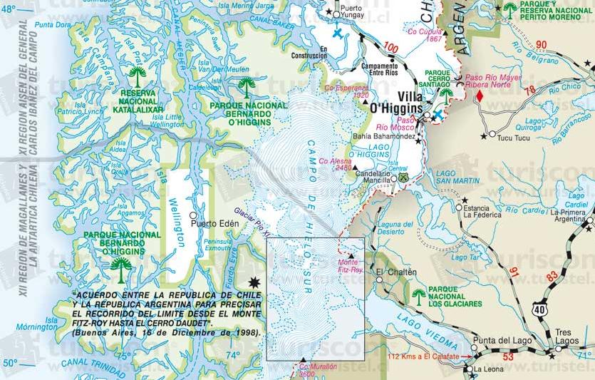
An Example of the Chilean Claim Another Example of Chilean Claim
And the Argentina claim is like the most of the wikipedia maps...
Open Street Map showing the limit
So, can we make that map neutral or, if Argentina can show it's claim everywhere, why Chile can't? --Janitoalevic (talk) 23:14, 29 February 2016 (UTC)
- There is no need to discuss this on several pages. I read what you wrote at TUBS' discussion page and I will answer there. NNW 09:02, 1 March 2016 (UTC)
|
|
File:AKWs Deutschland.png has been listed at Commons:Deletion requests so that the community can discuss whether it should be kept or not. We would appreciate it if you could go to voice your opinion about this at its entry.
If you created this file, please note that the fact that it has been proposed for deletion does not necessarily mean that we do not value your kind contribution. It simply means that one person believes that there is some specific problem with it, such as a copyright issue. Please see Commons:But it's my own work! for a guide on how to address these issues. |
Edroeh 13:53, 5 March 2016 (UTC)
Karten des Landkreises Cuxhaven edit

Moin NordNordWest, da du die letzen Aktualisierungen an File:Lamstedt in CUX.svg und den anderen Karten der Serie gemacht hast und User:Hagar66 als ursprünglicher Ersteller nicht mehr aktiv ist, melde ich mich mal bei dir und hoffe auf Rat: Mir ist aufgefallen, dass die Gemeinde Lamstedt mit einer Exklave an der Mehe (nahe der Oste) eingezeichnet ist. Der Status dieser Exklave ist mir etwas unklar und die beiden Links, die als Quelle angegeben sind, führen heute nur noch ins Leere.
Google Maps und OpenStreetMaps führen dieses Gebiet als Teil der Gemeinde Hollnseth. Der Wikipedia-Artikel de:Armstorf reklamiert die Exklave seit dieser Version als Teil von Armstorf. Das wird dadurch gestützt, dass die Gemarkungskarte des Landkreises Cuxhaven es als separate Gemarkung "Armstorf-Hollen" aufführt. Die zugehörige Gemeindekarte des Landkreises Cuxhaven dummerweise führt es als Teil von Hollnseth. Gehe ich dagegen in eine der Spezialkarten des Cuxland-GIS (hier zum Beispiel), wird die Exklave ein- und ausgeblendet, wenn ich Gemeindegrenzen ein- und ausblende. Allerdings ohne Hinweis, zu welcher Gemeinde das Gebiet gehört.
Ich vermute, dass das Gebiet im Zuge der Moorteilung der Gemeinde Armstorf zugeteilt wurde und zumindest bis zur Kommunalreform in den 1970er Jahren geblieben ist. Ob es danach bei Armstorf geblieben ist oder an Hollnseth oder Lamstedt gefallen ist, kann ich bisher nicht klären. Lamstedt würde meines Erachtens am wenigsten Sinn machen: wenn man das Gebiet umgemeindet hat, dann doch, um die Exklave zu beseitigen und nicht, um wieder eine neue Exklave zu schaffen.
Weißt du Rat oder Quellen, die das klären können? --Slomox (talk) 13:04, 10 March 2016 (UTC)
- Moin! Die Exklave existiert sicherlich, sie ist auch im Geoportal Niedersachsen zu finden und auch dort leider unbeschriftet. OSM und Google sind für sowas überhaupt nicht geeignet. Ich komme nachher noch in die Stadt und kann dort schauen, ob ich das TK25-Blatt 2420 finde. Auf dem ist eine Verwaltungsübersicht abgebildet. Sollte das nichts bringen, müsste der Landkreis Auskunft geben können. Wer ein GIS hat, sollte das auslesen können. Dass die Gemeindenamen nicht in jeder Zoomstufe eingeblendet werden können, ist wirklich Murks. NNW 13:40, 10 March 2016 (UTC)
- Natürlich war genau dieses Kartenblatt nicht da. Allerdings kann man über http://nibis.lbeg.de/cardomap3/?TH=618 eine Gemeindeabfrage machen, hier mit dem Ergebnis Armstorf. Das würde zu Wikipedia (hat ja immer recht :o) ) und zum Gemarkungsnamen passen. Und die Karten hier müssen angepasst werden. NNW 21:25, 10 March 2016 (UTC)
- Vielen Dank für deine Recherche! Wie funktioniert die Gemeindeabfrage? So ein Tool hätte ich schon öfter gebrauchen können.
- Um das Problem optisch zu fixen, müssen nur die Karten von Lamstedt und Armstorf geändert werden. Da der Path im SVG aber "Lamstedt" in der ID trägt, müssten theoretisch alle Karten im Landkreis angepasst werden. Falls du ein Tool hast, um alle Karten "in einem Rutsch" zu korrigieren, wäre das praktisch. Ansonsten würde ich nur die beiden Karten von Lamstedt und Armstorf händisch anpassen. --Slomox (talk) 06:57, 11 March 2016 (UTC)
- Ich habe die Karten der beiden betroffenen Gemeinden korrigiert. Da die anderen Karten eh im November aktualisiert werden müssen, spare ich mir das für den Rest, zumal der Fehler dort nur im Quelltext zu sehen ist und ich vermute, dass das niemanden interessiert. Beim NIBIS-Kartenserver blendest du links über den Punkt „Administrative Grenzen“ die Gemeinden ein und klickst dann einfach in die Flächen. Dann öffnet sich ein Fenster mit der Anzeige des Gemeindenamens. Bei anderen Geografischen Informationssystemen muss man in der Regel ein Werkzeug mit einem i oder ? als Symbol (z.B. bei OSM) dafür nehmen, manchmal auch vorher noch eine Objektebene auswählen, damit das Werkzeug weiß, in welcher Ebene die Abfrage ausgeführt werden soll. Leider wird so ein Abfragewerkzeug nicht in allen Internetanwendungen angeboten. NNW 10:50, 12 March 2016 (UTC)
- Vielen Dank für die Änderung und die Erklärung! Da du ja anscheinend Ahnung von GIS hast: gibt es ähnliche Tools auch auf Gemarkungsebene für ganz Niedersachsen? --Slomox (talk) 07:58, 14 March 2016 (UTC)
- Kann ich erstmal nichts zu sagen, da ich wenig mit Niedersachsen zu tun habe. Da müsste man das Geodatenportal Niedersachsen durchsuchen, ob dort sowas angeboten wird. NNW 09:59, 14 March 2016 (UTC)
A request edit
Can you make an alternate version of this Turkey_adm_location_map.svg? I'm using it in [2], since the other map is simply not accurate. The problem is that as you can see on the template [3], some links are obscured by the dark borders. Can you lighten them, thin them, or both? Not drastically but enough so the text is easier to see. Monochrome Monitor (talk) 18:55, 13 March 2016 (UTC)
- Could you please correct the links? NNW 19:27, 13 March 2016 (UTC)
- Sorry, those are english wikipedia links. Monochrome Monitor (talk) 02:07, 14 March 2016 (UTC)
- Fixed. The reason I am asking is because people keep reverting the map to the innacurate version because in this svg the text is harder to see. Monochrome Monitor (talk) 02:09, 14 March 2016 (UTC)
- I think the easiest way would be that you download that map, open the file with a simple text editor and replace all #646464 with a lighter color that you prefer and upload it as a new file just for this template. You can find some grey tones at http://www.farb-tabelle.de/en/table-of-color.htm. NNW 10:07, 14 March 2016 (UTC)
- Fixed. The reason I am asking is because people keep reverting the map to the innacurate version because in this svg the text is harder to see. Monochrome Monitor (talk) 02:09, 14 March 2016 (UTC)
- Sorry, those are english wikipedia links. Monochrome Monitor (talk) 02:07, 14 March 2016 (UTC)
- Thank you! Monochrome Monitor (talk) 13:31, 15 March 2016 (UTC)
Tokyo edit
I am glad to meet you. I am Yamada of the Japanese TV program production company. I wanted to quote 35 wards of Tokyo maps of your book by a program and contacted me. — Preceding unsigned comment added by 153.226.234.91 (talk • contribs)
- Hello!
- I think the only map of Tokyo I made is file:Tokio Eingemeindungen 1932-1936.png. You can use this map as long as you a) name the author and b) name and link the license. That can be like this:
- author: NordNordWest, license: CC BY-SA 3.0 de (http://creativecommons.org/licenses/by-sa/3.0/de/deed.en) or shorter
- NordNordWest, CC BY-SA 3.0 de (http://creativecommons.org/licenses/by-sa/3.0/de/deed.en)
- That's all. NNW 09:36, 16 March 2016 (UTC)
Hello.
Because I do not have English, I am sorry in a strange sentence. As an example, when I use it in a TV program, ①An author: NordNordWest, ②A license: CC BY-SA 3.0 de (http://creativecommons.org/licenses/by-sa/3.0/de/deed.en) Of above, two points let's be to be possible if list it?
- I am sorry but I am not sure that I really understand your question. NNW 09:50, 18 March 2016 (UTC)
New città metropolitana edit
There is a Città Metropolitana di Cagliari.--Driante70 (talk) 11:56, 20 March 2016 (UTC)
- I updated the map. NNW 18:19, 20 March 2016 (UTC)
- Could you please tell me what happened to the provinces of Sardinia? Was there a merger? I am not sure that I understand it:Città metropolitana di Cagliari#Processo istitutivo correctly. NNW 19:07, 20 March 2016 (UTC)
United Arab Emirates location map.svg edit
Hi.may I ask why the three (most important) islands of iran (Abu Musa & Greater and Lesser Tunbs) are marked white(if I see correctly) in this map?Tnx--Arian Ar (talk) 13:12, 24 March 2016 (UTC)
- Hello! They are disputed between Iran and UAE, so they are shown in light grey. NNW 14:19, 24 March 2016 (UTC)
Code issues in User:NordNordWest/common.js edit
Hi NordNordWest, I am a bored bot (this is kind of a computer program) that is watching the recent changes and tapping buttons like I did now.
Curious about the reason? Possibly not but I will tell you anyway:
- You edited User:NordNordWest/common.js. Glad to see you coding in javascript! Have you ever considered becoming a MediaWiki hacker?
- Though, that change appears to introduce 1 new jshint issue — the page's status is now having warnings. Note that invalid or ambiguous code often has unwanted side effects like breaking other tools for you. If you cannot find out how to fix it, I suggest blanking the page for now.
- To help you understanding where the issues are, I have aggregated a report here and now. If you have questions, don't hesitate to ask users experienced in javascript writing for help. But do not ask the bot's operators (chronically overwrought) unless you suspect an error of mine. If you prefer not getting spammed by me, you can opt-out reports by adding {{ValidationOptOut|type=all}} to your user page or cmb-opt-out anywhere on your your global user page on Meta. Good luck at Wikimedia Commons and happy hacking!
- ISSUE:
line 2 character 158: Missing semicolon. - Evidence:mw.loader.load('//commons.wikimedia.org/w/index.php?title=User:Magog the Ogre/cleanup.js&action=raw&ctype=text/javascript&action=raw&ctype=text/javascript') - ISSUE:
line 5 character 91: Script URL. - Evidence:mw.util.addPortletLink('p-tb', 'javascript:importScript("MediaWiki:VisualFileChange.js");', 'Perform batch task', 't-AjaxQuickDeleteOnDemand');
Your CommonsMaintenanceBot (talk) at 10:20, 2 April 2016 (UTC).
Hi ich bin auf deine Grafik und hätte gerne gewusst auf welcher Basis du die Karten erstellt hast. Also die Quelle der Positionen
Vielen Dank — Preceding unsigned comment added by Bastrollo (talk • contribs)
- Moin! Die Karte sollte den Artikel de:Paketzentrum (Deutsche Post DHL) illustrieren. Du müsstest daher den Autor bzw. die Autoren des Artikels fragen, woher die Daten in der Tabelle kommen. Selbst recherchiert habe ich nicht. Viele Grüße, NNW 08:06, 21 April 2016 (UTC)
Sorbisches Siedlungsgebiet edit
Hallo NNW! Lübben/Lubin und Calau/Kalawa sind ab sofort ebenfalls Teil des amtlichen sorbischen Siedlungsgebietes. Ich bitte dich, die Karten dementsprechend zu aktualisieren. Vielen Dank und schöne Grüße, j.budissin+/- 11:59, 21 April 2016 (UTC)
- Moin! Danke für den Hinweis. Da oben darf jetzt aber keine Gemeinde mehr beitreten, dafür wäre kein Platz. :o) Viele Grüße, NNW 12:42, 21 April 2016 (UTC)
- That was quick, alle Achtung. Sieht auch eher nicht danach aus :D Lieberose und Schwielochsee haben schon abgelehnt, die würden den Rahmen sprengen. Danke! --j.budissin+/- 12:51, 21 April 2016 (UTC)
- Sehe gerade, dass du bei der deutschen Version vergessen hast, die Gemeinden hinzuzufügen. Die sorbische stimmt. --j.budissin+/- 12:53, 21 April 2016 (UTC)
- In der deutschen Version sind sie auch, dein Browsercache zeigt nur die alte Version an. NNW 13:00, 21 April 2016 (UTC)
- Tatsache, ich dachte, purgen reicht aus. Sorry. --j.budissin+/- 13:13, 21 April 2016 (UTC)
- In der deutschen Version sind sie auch, dein Browsercache zeigt nur die alte Version an. NNW 13:00, 21 April 2016 (UTC)
- Sehe gerade, dass du bei der deutschen Version vergessen hast, die Gemeinden hinzuzufügen. Die sorbische stimmt. --j.budissin+/- 12:53, 21 April 2016 (UTC)
- That was quick, alle Achtung. Sieht auch eher nicht danach aus :D Lieberose und Schwielochsee haben schon abgelehnt, die würden den Rahmen sprengen. Danke! --j.budissin+/- 12:51, 21 April 2016 (UTC)
- Evangelisch.de: Segnung homosexueller Paare, Bunt wie ein Regenbogen
- HUK.org: Möglichkeiten der kirchlichen Segnung gleichgeschlechtlicher Paare
In der Evangelischen Landeskirche Anhalt und der Evangelisch-Lutherischen Kirche in Bayern ist die öffentliche Segnung eines gleichgeschlechtlichen Paares im Gottesdienst erlaubt. Das Gebiet der Evangelisch-Lutherischen Kirche in Bayern und der Evangelischen Landeskirche Anhalts sollte daher in der Karte dunkel-lila dargestellt werden. --92.76.106.221 13:47, 22 April 2016 (UTC) Vielleicht könntest Du die Karte daher aktualisieren, da Du in der Versionsgeschichte der Datei dies öfters bereits gemacht hast, würde es mich freuen, wenn Du dies erledigst. --92.76.106.221 13:49, 22 April 2016 (UTC)
- Die Karte illustriert den Artikel de:Segnung gleichgeschlechtlicher Paare. Erst muss der Artikel entsprechend bearbeitet werden, dann erst ist es sinnvoll, auch die Karte zu ändern. Beachte bitte den Punkt de:Diskussion:Segnung gleichgeschlechtlicher Paare#Bayern. Ich stecke zu wenig in der Materie drin, um beurteilen zu können, was wie eingefärbt sein muss. NNW 16:20, 22 April 2016 (UTC)
- Befürwortende Synodenentscheidung am 23. April 2016: Evangelische Landeskirche in Baden
- Badische Zeitung: Landeskirche genehmigt gleichgeschlechtliche Trauungen
- Stuttgarter Zeitung: Landessynode genehmigt Homo-Trauungen
In der Evangelischen Landeskirche in Baden ist die Segnung gleichgeschlechtlicher Paare in einem Traugottesdienst am 23. April 2016 durch die Synode ermöglicht worden. Das Gebiet der Evangelischen Landeskirche in Baden sollte daher in der Karte dunkel-lila gefärbt werden. --92.76.104.111 11:37, 23 April 2016 (UTC)
- Siehe einen Punkt höher. NNW 10:12, 24 April 2016 (UTC)
Creating a zip code map edit
Hello! Would it be possible for you to create a vector image of the lower 48 US zip code tabulation areas? The shape file is here: [4] and somebody did a Javascript implementation here: [5]. Magog the Ogre (talk) (contribs) 00:04, 24 April 2016 (UTC)
- Hello! I opened the SVG file and it contains thousands of tiny areas like in file:5 digit ZCTAs in Virginia.svg. If you want to be able to identify any of these areas then this would be a hugh map. This isn't sensible for the lower 48. NNW 10:12, 24 April 2016 (UTC)
Distribution maps edit
I created a distribution map for manx shearwater based closely on (but not copied directly from] the HBW map. You deleted it as a copyright violation.
I have a dilemma here. If I create a map which closely follows the source map, you are likely to delete it as a copyright violation, but to get articles through the en-wiki featured article process I have to include a distribution map, which has not previously led to problems. Until now it's been accepted that a hand-drawn map is acceptable since it is, by definition, bound to show the same information as the source map
It seems to me that the only way around the copyright issue is to produce a map with deliberate inaccuracies or distortions, beyond those resulting from my draughtsmanship, which seems against the spirit of Wikipedia and will create problems at FAC. As I understand it, you seem to be saying that accurate maps are not acceptable on Commons. I'd welcome clarification on this policy because I want to get Manx shearwater to featured article, and I've no idea how to make a map that is both accurate and that you won't delete
thanks Jimfbleak (talk) 13:25, 25 April 2016 (UTC)
- Hello! I just opened http://www.hbw.com/sites/default/files/styles/m_1/public/maps/checklist/manx_shearwater_puffinus_puffinus_distribution_map.jpg and File:Puffinus puffinus distribution map.jpg and copied both files into one file in Photoshop: same size, same projection, same accuracy of the coastlines and borders, same distribution area, even same colours. Even if you chose the same scale and projection of the original version it would be impossible to recreate exactly the same coastlines. Cartographic generalization cannot be reproduced, not even by the same person. If your file wasn't just a cropped version of the HBW map then I cannot see the difference.
- Of course you can show the same distribution area without any inaccuracy but your map has to be different from the original map. You can change projection and colours and the background map and it will look completely different and it is okay for Commons. Just try File:BlankMap-World6-Equirectangular.svg or File:BlankMap-World7.svg as a background map and nobody will complain. Regards, NNW 14:03, 25 April 2016 (UTC)
SVG tagging/categorizing edit
Hallo NNW, du bereicherst die Wikipedia um eine Menge hochwertiger Karten. Würde es dir etwas ausmachen, die Beschreibungen deiner SVG-Dateien gleich bei der Erstellung mit zusätzlichen Angaben zu versehen bezüglich des Erstellungstools (Inkscape, AI) und dabei auch für die richtige Subkategorierung zu sorgen? Geht ganz leicht, ich hab es mal für deine letzten paar Uploads nachgetragen (ist dir hoffentlich recht). Wenn was unklar ist, helfe ich auch gerne. Mfg sarang♥사랑 11:56, 13 May 2016 (UTC)
- Moin! Ich verstehe, ehrlich gesagt, den Mehrwert nicht, den diese Vorlage bringt. Welchen Vorteil hat es, das Erstellungsprogramm zu kennen? Selbst die Validitätsprüfung scheint mir sinnlos zu sein, da mir bei einigen Dateien ein fehlerhafter Quelltext bescheinigt wurde, die Datei aber trotzdem korrekt dargestellt wird. Viele Grüße, NNW 14:27, 13 May 2016 (UTC)
- Die Information über das Erstellungsprogramm hilft vor allen den Benutzern die noch nicht so versiert sind und vor der Frage stehen mit welchem Tool sie es versuchen sollen. Darüber hinaus gibt es viele technisch interessierte Benutzer die gerne wüssten, und auf einen Blick sehen wollen, wie und womit eine Grafik entwickelt worden ist - das erscheint mindestens so sinnhaft wie anderes.
- Kategorien sind ein sehr brauchbares Mittel um etwas zu suchen und zu finden. U.a. bewahren ausreichend feine Unterteilungen davor, dass Kategorien allzu mächtig und damit unübersichtlich werden; das wird durch Subkategorien bewirkt.
- Die W3C-Validität enthält keine Aussage zur Darstellung einer Grafik (auch nicht zur Qualifikation des Erstellers), sie ist vor allem ein Kriterium zur Kategoriediffusion. Allerdings sollten IMHO die Formalismen eingehalten und bevorzugt W3C-valide Dateien erzeugt werden. In diesem Sinn werben die Hinweise dafür, Dateien vor dem Hochladen zu prüfen um sie ggf. zu bereinigen.
- Es ist einfacher diese tags gleich beim Hochladen in die Beschreibung einzufügen als sie später nachzuschiessen. Aber das macht natürlich jeder wie er meint! Gruss, sarang♥사랑 09:13, 14 May 2016 (UTC)
- Es ist doch völlig egal, ob ich ein SVG mit Illustrator oder mit Inkscape bearbeite, genauso egal, ob ich ein Grafikdatei mit Gimp oder Photoshop bearbeite. Das einzig wirklich Wichtige beim SVG ist, ob sich jemand die Mühe gemacht hat, den Quelltext auch halbwegs verständlich für Menschen zu machen oder nicht. Wenn ich so eine überarbeite Version mit einem Grafikprogramm verändere, ist das Lesbare nämlich hin. Ich persönlich erstelle SVGs nur mit Grafikprogrammen und wenn die nicht in der Lage sind, einen korrekten Quelltext abzuliefern, dann kann ich das auch nicht ändern. Ich kann kein XML.
- Und noch was zu den Tags: Gerade bei Dateien wie CDU Landtage.svg, die von einer Vielzahl von Leuten aktualisiert werden, wird sich das verwendete Programm immer wieder verändern. Ich würde nicht erwarten, dass dann jedesmal auch die Prüfung der Validität gemacht wird und die Programmnennung angepasst wird. Bei AfD Landtage.svg hat es bei der letzten Aktualisierung nicht mal dazu ausgereicht, den sehr einfach zu verändernden deutschen Text im Hinweiskästchen anzupassen, wer soll da mit den kryptischen Abkürzungen von {{Igen}} klarkommen? Das funktioniert nie, es bleiben dann Hinweise, die einfach nicht mehr stimmen. NNW 16:28, 14 May 2016 (UTC)
Mix-Flaggen edit
Moin NNW, magst Du mir mal wieder zwei Flaggen mixen, wie Du es schon mehrfach getan hast? Diesmal wären es Kanada und Südkorea (ich weiß, gibt akuten Augenkrebs, wäre aber trotzdem nett). Vielen Dank sagt der Mogelzahn (talk) 16:18, 19 May 2016 (UTC)
- Moin! Bitteschööön: Flag of Canada and South Korea.svg. Hässlich ist gar kein Ausdruck. Diagonal geteilt funktionierte hier überhaupt nicht. NNW 19:54, 19 May 2016 (UTC)
- Dankeschön! --Mogelzahn (talk) 19:54, 19 May 2016 (UTC)
How to configure adm maps? edit
Hello, in the Spanish Wikipedia i've not seen any adm map, because the "|aspectRatio=" section doesn't seem to work when i tried to implement it. That's because is not in the spanish Template? or it has another name?--Janitoalevic (talk) 01:10, 30 May 2016 (UTC)
- Hello! Unfortunately all these templates are bit different in the Wikipedias. The new adm series works like the old location map series, it is just a question of the projection. For maps with a conic projection (like the new Chile or Argentina map) you will have to do it like in es:Plantilla:Mapa de localización de Rusia. NNW 07:40, 30 May 2016 (UTC)
Grafik DFB-Pokalsieger edit
Die Grafik der Pokalsieger (Karte_DFB-Pokalsieger.png) müsste bitte noch angepasst werden. 2016 hat - leider schon wieder - der Club aus München gewonnen. --Vertigo Man-iac (talk) 11:46, 30 May 2016 (UTC)
- Danke für den Hinweis, die habe ich nie so richtig auf dem Schirm. NNW 12:25, 30 May 2016 (UTC)
- Danke für's Aktualisieren. --Vertigo Man-iac (talk) 15:06, 31 May 2016 (UTC)
Sächsische Kantoneinteilung edit
Moin NNW, hältst Du es für sinnvoll, aus dieser schönen Zeichnung eine noch schönere farbige Grafik zu machen? Wäre ich da richtig?--Mehlauge (talk) 04:05, 31 May 2016 (UTC)
- Moin! Das kannst du natürlich gerne versuchen, wobei die de:WP:Kartenwerkstatt vermutlich etwas mehr Ergebnisse bringt als das hiesige Graphic Lab (aber beides dauert gerne lang). Außerdem musst du damit rechnen, dass man dir sagt, dass die Karte ja funktioniert und eine Umwandlung eher Luxus ist angesichts der Anzahl der noch wartenden Kartenwünsche. Viele Grüße, NNW 08:27, 31 May 2016 (UTC)
- Moin auch. Ich lasse es erst mal. Danke.--Mehlauge (talk) 23:34, 1 June 2016 (UTC)
Unitary council maps for Northern Ireland that you made edit
Hi NordNordWest, I noticed that you created the original File:Northern_Ireland_location_map.svg file showing Northern Irelands unitary council districts. I also notice you created the newer district maps such as File:Causeway_Coast_and_Glens_district_in_Northern_Ireland.svg.
Could you please create a new Northern Ireland location map that depicts the new eleven councils to replace the now outdated location map? Mabuska (talk) 23:11, 7 June 2016 (UTC)
- Hello! United Kingdom Northern Ireland adm location map.svg is already available. NNW 06:50, 8 June 2016 (UTC)
- Brilliant stuff! Many thanks! Mabuska (talk) 13:12, 12 June 2016 (UTC)
|
|
File:Pakistan location map.svg has been listed at Commons:Deletion requests so that the community can discuss whether it should be kept or not. We would appreciate it if you could go to voice your opinion about this at its entry.
If you created this file, please note that the fact that it has been proposed for deletion does not necessarily mean that we do not value your kind contribution. It simply means that one person believes that there is some specific problem with it, such as a copyright issue. Please see Commons:But it's my own work! for a guide on how to address these issues. |
2401:FA00:C:14:D5C6:CA91:BFB2:D415 20:17, 24 June 2016 (UTC)
File:Lächel mal wieder.nnw.jpg edit
'Nabend, NNW! Beim ausgiebigen virtuellen Schlendern durch Winterhudes Skulpturen und Stadtpark kam die blickfreie Bank gerade recht ... Wo genau sie wohl steht – oder will sie gesucht und gefunden werden? Jedenfalls ein netter background für ein Motivations-Selfie. Na ja, ein Desktop-Begrüßungsbild tut's auch. Smiling: --Vitavia (talk) 18:20, 17 July 2016 (UTC)
- Moin! Die kannst du an der Wegekreuzung westlich vom Landhaus Walter finden [6]. Allerdings sitzen da ganz häufig Leute, du musst also etwas Glück mitbringen. Viele Grüße, NNW 07:48, 18 July 2016 (UTC)
- Danke NNW, insbesondere für die gezielte Ortsangabe, dorthin kann man ja bequem mit dem 179er gelangen. Alternativ (oder zusätzlich) interessiert beim nahegelegenen Landhaus Rex' Brunnen-Skulptur von hinten - die einschlägige Ohlsdorf-Literatur erwähnt von ihm zwei Grabmale, wovon nur eines durch Signatur gesichert ... Ebenfalls viele Grüße, --Vitavia (talk) 09:09, 18 July 2016 (UTC)
- Done, NNW! Alle Bänke waren leer, nur die eine nicht, aber der Draufsitzende machte ohne Umschweife einen Schnappschuss von mir + Spruch und entfernte sich danach “glück”licherweise. Dann die Erkenntnis, dass es mancher Verrenkung bedarf, um selbst die richtigen Körperteile und gleichzeitig die Schrift abzubilden.
Zum Rex-Brunnen: von hinten (Signatur), seitlich (Frisur) und aus der Distanz fotografiert. Auf Grund von Wilhelm Rex und den Commons-Dateien hatte ich angenommen, dass es sich um zwei unterschiedliche Brunnen handelt: einen frühen Mädel-Br. und den aktuellen Knaben-Br.. Heute sehe ich aber eine typisch weibl. Frisur, und beim Federvieh könnte es sich ebensogut um Gänse handeln ... Wegen dieser Diskrepanzen habe ich die heutigen Bilder nur “Rex-Brunnen LandhausWalter HamburgWinterhude” genannt. Hoffe, soweit ok, sonst bitte renaming (lassen). Sommerliche Grüße, --Vitavia (talk) 17:27, 20 July 2016 (UTC)
- Done, NNW! Alle Bänke waren leer, nur die eine nicht, aber der Draufsitzende machte ohne Umschweife einen Schnappschuss von mir + Spruch und entfernte sich danach “glück”licherweise. Dann die Erkenntnis, dass es mancher Verrenkung bedarf, um selbst die richtigen Körperteile und gleichzeitig die Schrift abzubilden.
- Ich muss gestehen, dass ich mich nicht sonderlich um das Geschlecht der Figur gekümmert habe (zumal Mädels und Jungs je nach Alter, Jahrhundert und darstellendem Künstler erschütternd ähnlich aussehen können). :o) NNW 08:16, 21 July 2016 (UTC)
- Der von dir verwendete Skulpturname findet so bereits auf etlichen Internetseiten Erwähnung, am seriösesten wohl auf dem Stadtpark-Plan der Behörde (Skulptur Nr. 17), und Wikipedia will ja an Texten auch nur abbilden was schon da ist. Einen freundlich lächelnden Tag wünscht --Vitavia (talk) 09:22, 21 July 2016 (UTC)
- Dann gehe ich mal davon aus, dass es keinen Handlungsbedarf bzgl. meiner Dateibenennung gegeben hat. Gruß --Vitavia (talk) 07:05, 8 August 2016 (UTC)
- Vermutlich nicht, wenn bislang nichts passiert ist. NNW 09:00, 8 August 2016 (UTC)
Belarus location map. edit
Hi, I just wanted to ask why the new File:Belarus adm location map.svg is missing so many lakes compared to the old File:Belarus location map.svg. Doesn't that only take away from the detail? --Turnless (talk) 17:03, 18 July 2016 (UTC)
- It's a question of generalization. I think it is senseless to show all these small lakes. It would be justified if the map would show rivers that detailed as well but it doesn't. And if it would do it wouldn't be a good location map. NNW 17:12, 18 July 2016 (UTC)
- Alright fair enough. I wanted to talk to you about a few other issues but I will just start a new topic. --Turnless (talk) 17:16, 18 July 2016 (UTC)
Request for new location maps edit
Hi, I wanted to request a couple of new location maps for you to make. First, could you make one of your series N location maps for Azerbaijan with the break-away region hatched. Keep in mind the territorial changes that occurred in 2016 that you can find here [7]. Can you also update File:Transcaucasia adm location map.svg with the territorial changes in the Nagorno-Karabakh Republic. I also wanted to ask you to create your own series N Russia location map with the disputed Crimea hatched. There is File:Russia adm location map.svg already existing, but it looks a bit off in quite a few places. The most notable being the disputed Crimea as the hatching looks very different than in other location map and it also looks much closer connected to Ukraine then it really is because of the way the Syvash was drawn. It also misses a disputed dashed border between Ukraine and Crimea. There is File:Russia political location map (Crimea disputed).svg that does represent the shape of Crimea better but does not use hatching which is now the generally more accepted format for disputed regions. I hope that you could create a new map for Russia based on your own mapping standards. I also wanted to ask you to add a dashed disputed border between Crime and Ukraine to File:Russia political location map (Crimea disputed).svg going across the Syvash similar to the one at File:Ukraine adm location map.svg. Sorry for asking for so many requests, I hope you could still accomplish this. Thank you! --Turnless (talk) 18:48, 18 July 2016 (UTC)
.svg)
- Hello! All these maps are quite on top of my to-do-list, especially the Azerbaijan map. :o) It is just a question of time. NNW 07:29, 19 July 2016 (UTC)
- Alright, great to hear that! It would be great if you could let me know when they are uploaded. Thanks a lot! :) --Turnless (talk) 15:54, 19 July 2016 (UTC)
- Update. I renamed the file "Russia adm location map.svg" to File:Russia administrative location map.svg so that you can use the title for your own location map of Russia that you plan to eventually upload. --Turnless (talk) 17:37, 19 July 2016 (UTC)
- I'm sorry, I meant to ask you to add a dashed disputed border between Crimea and Ukraine to File:European Russia laea location map (Crimea disputed).svg not File:Russia political location map (Crimea disputed).svg. I also wanted to ask if that map is part of our series N or the 2008 standard as it is not present in your location maps gallery. --Turnless (talk) 18:39, 19 July 2016 (UTC)
.svg)
- file:European Russia laea location map (Crimea disputed).svg is a derived work, I do not add those to my gallery. The main differences between the two series are the lighter blue and the hatched areas in the N series, so this is a mixture of both. Btw, it will take some time until these maps will be made. My list of maps to be done is long, I promised to finished other maps and it is summer. NNW 08:09, 20 July 2016 (UTC)
- I understand, take your time. --Turnless (talk) 16:21, 20 July 2016 (UTC)
Can you also add a similar but solid border between Crimea and Ukraine on File:European Russia laea location map (incl Crimea).svg? --Turnless (talk) 04:06, 5 August 2016 (UTC)
.svg)
- Nun, die Annexion der Krim durch Russland ist bisher völkerrechtlich nicht anerkannt. Das bitte ich doch zu berücksichtigen. --Mogelzahn (talk) 21:04, 5 August 2016 (UTC)
- Done. @Mogelzahn: Wenn irgendeine Sprachversion das so will, ist das ihr Problem. In Russland gilt die Annexion als gültig. NNW 16:22, 6 August 2016 (UTC)
Azerbaijan adm location map.svg is available now. NNW 20:23, 10 August 2016 (UTC)
- So am Rand: Sind das hier sachdienliche Hinweise? Habe den guten Mann böse gebremst, aber irgendwie schein der Detailwissen zu haben (was ich nichtmal richtig verifizieren kann)--TUBS
 20:02, 12 August 2016 (UTC)
- An sich ja, allerdings wurde das schon berücksichtigt. en:Çocuq Mərcanlı ist auch bei der neuen Karte nicht bergkarabachisch (neues Wort, gehört mir!). Der oben genannte Link http://caucasus.liveuamap.com scheint mir da ganz vertrauenswürdig. NNW 10:20, 13 August 2016 (UTC)
- Thank you! Can you also update the borders of Nagorno-Karabakh on the Transcaucasia map? --Turnless (talk) 02:55, 15 August 2016 (UTC)
- It is updated now. NNW 08:16, 15 August 2016 (UTC)
Soviet Republics location maps edit
Hi, sorry I keep bothering you with my requests, but this one shouldn't be as complicated. I noticed that you have already made maps of 11 of the 15 former Soviet Socialist Republics of the former Soviet Union with the exception of Russia, Azerbaijan, Latvia, and Lithuania. Because of that, I wanted to ask you to make location maps of the former Soviet Socialist Republics with their territorial state prior to the collapse. For example, the Ukrainian SSR looked the same as Ukraine does now except with Crimea from 1954-1991. I'm not even going to bother you with the earlier maps of the Republics as I know you are very busy and it may take more time (but down the road, it would be quite helpful). Those maps will be good for use on articles such as en:1991 Soviet Lower Second League, Zone 1 and many more. Thank you! --Turnless (talk) 17:00, 20 July 2016 (UTC)
- As long as there are so many requested maps to be done any further requests are psychologically bad. :o) NNW 08:18, 21 July 2016 (UTC)
- Alright, it is understandable as you do probably have a lot of maps to finish. --Turnless (talk) 15:54, 21 July 2016 (UTC)
- Do you have a knowledge of editing topography maps? There is a map of Georgian Topography that missed out a border between Guria and Samegrelo-Zemo Svaneti File:Relief Map of Georgia.png. There is an SVG version available but it misses the disputed regions. --Turnless (talk) 16:25, 21 July 2016 (UTC)
- A map is a map, it doesn't matter if it is administrative, topographic or anything else. NNW 19:22, 23 July 2016 (UTC)
- So then do you think you can add the border between Guria and Samegrelo-Zemo Svaneti for File:Relief Map of Georgia.png? --Turnless (talk) 19:18, 24 July 2016 (UTC)
- It is added now. NNW 20:49, 25 July 2016 (UTC)
- Thank you! --Turnless (talk) 22:26, 25 July 2016 (UTC)
deleted files edit
how can i view deleted files to check their copyrights ? — Preceding unsigned comment added by Tunisianball777 (talk • contribs) 17:05, 20 July 2016 (UTC)
Aktion BVU edit
Hallo NNW, ich war am Wochenende mal mit der Kamera auf dem Wasser und - wie erwartet - war dort extrem viel Verkehr. Ich habe aber mit viel Glück & Geduld nun drei Bilder beisteuern können. Übrigens ist auf jedem der drei Bilder ein weiterer Verkehrsteilnehmer zu sehen - ist aber ein Suchspiel. Zu der Aktion sind mir zwei Fragen eingefallen:
- Ist es wünschenswert, jeweils ein Foto von jeder Brückenseite zu haben?
- Hatte ich es richtig verstanden, dass es nur um die Straßenbrücken geht?
Fragende Grüße, --Enter (talk) 13:49, 25 July 2016 (UTC)
- Moin! Bilder von jeder Seite wären nicht schlecht, aber da könnten dir die Lichtverhältnisse, Baustellen usw. sehr schnell einen Strich durch die Rechnung machen. Die Bilder sind für die Liste von Brücken in Hamburg, die alle benannten Brücken umfasst. Es muss also nicht zwangsläufig eine Straßenbrücke sein. Im Innenstadtbereich haben aber, soweit ich mich erinnere, alle Brücken einen Namen. Tatsächlich könnte man grundsätzlich auch alle Brücken fotografieren. In der Liste der Alsterbrücken kommen eine ganze Reihe von namenlosen Brücken vor. Falls man auch andere Gewässer mit solchen Listen erstellen will, wird man also auch die namenlosen Brücken brauchen. Allerdings wirst du da mit deinem Gefährt wohl gar nicht hinkommen. Viele Grüße, NNW 20:39, 25 July 2016 (UTC)
- Danke für die Infos! Ich habe nach vier Stunden auf See nun acht weitere Bilder und eine erheblich größere Menge für meine Privatsammlung: "Menschen, die aus unerfindlichen Gründen stundenlang an Brückengeländern rumlungern". Wie gesagt, auf/an/über Hamburgs Wasserstraßen ist eine ganze Menge los. Also bin ich ganz froh, wenn ich in "dieser Saison" Barmbek, Uhlenhorst und einen Teil von Winterhude schaffe. Für alle "härteren Fälle" habe ich zudem ein aufblasbares SUP-board, das ich im Rucksack transportieren kann - wo Wasser ist, da komme ich also auch hin :-) Schaut Emma denn immer mal selbst nach neuen Bildern auf Commons, oder soll ich mich bei ihr melden? Fragende Grüße, --Enter (talk) 18:52, 27 July 2016 (UTC)
- Du kannst das jeweils beste Bild direkt in ihre Tabelle eintragen. NNW 18:57, 27 July 2016 (UTC)
- Darf ich auch eine ganze Spalte hinzufügen? Ich habe hier Eine -> File:Großheidesteg.JPG, für die es keinen Eintrag gibt. --Enter (talk) 16:45, 28 July 2016 (UTC)
- Wenn eine benannte Brücke fehlt, dann auf jeden Fall. Der Großheidesteg ist irgendwie durchgerutscht. NNW 21:05, 28 July 2016 (UTC)
- OK, ist gemacht, nur das mit den Koordinaten bekomme ich leider nicht hin. --Enter (talk) 10:31, 29 July 2016 (UTC)
- Wenn eine benannte Brücke fehlt, dann auf jeden Fall. Der Großheidesteg ist irgendwie durchgerutscht. NNW 21:05, 28 July 2016 (UTC)
- Darf ich auch eine ganze Spalte hinzufügen? Ich habe hier Eine -> File:Großheidesteg.JPG, für die es keinen Eintrag gibt. --Enter (talk) 16:45, 28 July 2016 (UTC)
- Du kannst das jeweils beste Bild direkt in ihre Tabelle eintragen. NNW 18:57, 27 July 2016 (UTC)
Hello! Location maps never show text because they are used in almost all projects and some of them don't even use Latin letters. That's why I will revert to the last version of this file. Of course you can upload your version as a new file. NNW 12:29, 31 July 2016 (UTC)
- Ah, OK. So I will do. Danke, --Julieta39 (talk) 15:42, 31 July 2016 (UTC)
Frankfurt edit
Hey, I've seen many maps that you created and I was very impressed.
U are probably gonna be busy, but I've got to ask: Will you please create a location map of Frankfurt?
If you want to, you can create it using Lage Riederwald in Frankfurt.png.
Thanks in advance--Mikey641 (talk) 23:40, 31 July 2016 (UTC)
- Hello! There are better maps available. You can use Frankfurt Subdivisions blank boroughs grey.svg or Frankfurt Subdivisions blank districts grey.svg with
- N: 50.2330555
- S: 50.0092805
- W: 8.46313333
- E: 8.81109444
- NNW 08:32, 1 August 2016 (UTC)
- Thanks you! these are perfect! --Mikey641 (talk) 11:32, 1 August 2016 (UTC)
- Just a small question. Where did you get the coordinates from? --Mikey641 (talk) 19:32, 15 August 2016 (UTC)
- Thanks you! these are perfect! --Mikey641 (talk) 11:32, 1 August 2016 (UTC)
- I imported the map in Google Earth and fitted it there. There is a window with the coordinates of the embedded image. NNW 08:00, 16 August 2016 (UTC)
- Thx. I looked for something like this for a long time--Mikey641 (talk) 23:18, 16 August 2016 (UTC)
- I imported the map in Google Earth and fitted it there. There is a window with the coordinates of the embedded image. NNW 08:00, 16 August 2016 (UTC)
Mal wieder eine Flaggenmixbitte edit
Könntest Du mir den Gefallen tun und mir eine Mixflagge nach bekanntem Muster aus den Flaggen Bulgariens und Russlands basteln? --Mogelzahn (talk) 16:48, 4 August 2016 (UTC)
- Moin! Flag of Bulgaria and Russia.svg ist nun vorhanden. NNW 16:20, 6 August 2016 (UTC)
- Danke schön! --Mogelzahn (talk) 18:14, 7 August 2016 (UTC)
Hey, I saw that you updated the file File:Bangladesh, administrative divisions - de - monochrome.svg. Any chance you can update File:Bangladesh, administrative divisions - Nmbrs - monochrome.svg too? Thanks--Mikey641 (talk) 19:03, 7 August 2016 (UTC)
- Hello! There was a chance. :o) NNW 08:59, 8 August 2016 (UTC)
- Thank you!!!!!
 --Mikey641 (talk) 09:43, 8 August 2016 (UTC)
- Thank you!!!!!
maps edit
Hello. Iwould like to create maps for the provinces of Cambodia (for the geolocalization). I don't know how to create them or how to start them. Regards --Io Herodotus (talk) 02:24, 14 August 2016 (UTC)
- Hello! You need to know to work with a vector graphics program like Inkscape, Illustrator or CorelDraw (better) or a raster graphic program like Gimp or Photoshop (worse). Then it is necessary to know what map projections are and how they work. Without this knowledge it is senseless to start to work on location maps. Do you have the knowledge? Regards, NNW 11:59, 15 August 2016 (UTC)
- Thank you for your anwer. I know what a map projection is, only on theory, I have tried to use Inskape but I gave up, I couldn't find the tutorials for that. Nevertherless I have created some maps Zuiderzee Works, Stelling van Amsterdam or Plan Delta. Do you think that's enough ?--Io Herodotus (talk) 14:17, 15 August 2016 (UTC)
- Difficult to say. It depends on how good you want to have your maps. Which source do you want to use? You could use OSM but it has the wrong projection. You could ignore this because the provinces in Cambodia are relatively small but if you want to create a correct location map then OSM won't be a good source for you. Then you will have to be attentive with the data, e.g. it is a pity that you chose JPG for Stelling van Amsterdam the Netherlands blank.jpg. The first version is a map with sharp edges but the more you changed the file the more blurred it became. This could have been avoided by using PNG instead of JPG. For location maps it is important to have a good quality of data because you don't know in which size your location map will be used (that's why a vector graphic is always better than a raster graphic). NNW 14:46, 15 August 2016 (UTC)
Hey. I created a location map for Tel Aviv-Yafo using OSM and This Map. Only if you want to, (if you are too busy or something it's okay)
Can you:
- Make a stroke for Ayalon River? I wasn't able to.
- Set the right stroke size, i wasn't sure on how many pt should it be.
Find the coordinates- If you find anything that needs fixing, please fix it.
Thanks in advance!--Mikey641 (talk) 17:21, 19 August 2016 (UTC)
- Hello! The stroke size changes from map to map, it just has to look okay. :o) I changed the background colour (dark grey is for other countries, light grey for the same country but outside the main area) and the colour of the shoreline and the river to the new (lighter) version, the shoreline now completely in blue, not in grey. It makes it easier to read names which sometimes can be seen in location maps. I hope you like it, otherwise just revert. NNW 17:32, 20 August 2016 (UTC)
- Thank you so much. It looks way better. For the next map i create i'm gonna use these colors.
- And a question, How did you change the shoreline's color? Is it something automatic or did you redrawed it?--Mikey641 (talk) 19:03, 20 August 2016 (UTC)
- I cloned the land area and took it as a coastline. NNW 19:04, 20 August 2016 (UTC)
- Thank you, needed it for map of Haifa--Mikey641 (talk) 21:48, 20 August 2016 (UTC)
- I cloned the land area and took it as a coastline. NNW 19:04, 20 August 2016 (UTC)
Hallo NordNordWest, wie auch auf der Diskussionsseite der Datei zu lesen ist (nicht von mir), ist der Name einer Stadt falsch geschrieben. Der Benutzer, der den Fehler eingefügt hat, ist aber seit einiger Zeit inaktiv. Gibt es irgendeine Stelle, die das korrigieren kann? Grüße --84.161.157.57 15:44, 28 August 2016 (UTC)
- Moin! Du kannst sowas auf de:Wikipedia:Kartenwerkstatt/Kartenwünsche eintragen. Das hier habe ich jetzt schon mal direkt korrigiert. Viele Grüße, NNW 16:20, 28 August 2016 (UTC)

Hello, do you have a vector version of the DFB-Pokalsieger map? Was hoping to translate to English. Secret Agent Julio (talk) 16:14, 28 August 2016 (UTC)
- I only have it as a FreeHand file and almost no one has got a running FreeHand version, so this won't help you. If you want to have a translated version it would be easier that I do it myself. The only word that has to be translated is "Pokalsieger" in the headline, is this correct? NNW 16:24, 28 August 2016 (UTC)
- Yeah, just a few adjustments if you wouldn't mind. If you could make the title "DFB-Pokal winners", remove the dash in Tschammerpokal, say "DFB-Pokal (since 1952)", and just a few club name adjustments, changing them to "Schalke 04", "Rapid Wein", "Bayern Munich", "1860 Munich", "Bayer Leverkusen", "Bayer Uerdingen", and "First Vienna", that would be great, thanks so much! Secret Agent Julio (talk) 17:43, 28 August 2016 (UTC)
- The file is available now. NNW 08:20, 29 August 2016 (UTC)
- Thanks so much! Secret Agent Julio (talk) 11:42, 29 August 2016 (UTC)
- The file is available now. NNW 08:20, 29 August 2016 (UTC)
- Yeah, just a few adjustments if you wouldn't mind. If you could make the title "DFB-Pokal winners", remove the dash in Tschammerpokal, say "DFB-Pokal (since 1952)", and just a few club name adjustments, changing them to "Schalke 04", "Rapid Wein", "Bayern Munich", "1860 Munich", "Bayer Leverkusen", "Bayer Uerdingen", and "First Vienna", that would be great, thanks so much! Secret Agent Julio (talk) 17:43, 28 August 2016 (UTC)
|
|
File:Tel Aviv-Yafo location map.svg has been listed at Commons:Deletion requests so that the community can discuss whether it should be kept or not. We would appreciate it if you could go to voice your opinion about this at its entry.
If you created this file, please note that the fact that it has been proposed for deletion does not necessarily mean that we do not value your kind contribution. It simply means that one person believes that there is some specific problem with it, such as a copyright issue. Please see Commons:But it's my own work! for a guide on how to address these issues. |
Bahn Hamburg Oberhafen edit
Moin NNW. Du hast die schöne Karte gemacht. Jetzt sitze ich an dem „Gleisdreieck“ zwischen Norderelbbrücke, Rothenburgsort und Klostertor de:Gleisdreieck Oberhafen. Hältst Du es für sinnvoll, davon eine Zeichnung zu machen?--Mehlauge (talk) 16:50, 3 September 2016 (UTC)
- Moin! Ich denke schon, dass eine Karte dem Leser eines deutlicher machen würde als allein der Text, weil da ein komplizierter Sachverhalt dargestellt wird. Dafür sollte das Gleisdreieck allerdings im Netz der Strecken Richtung Hbf, Süden, Berlin und Güterumgehungsbahn zu sehen sein, nicht nur das Gleisdreieck an sich. Da ich schon einigen Leuten Karten versprochen habe, die ich auf jeden Fall vorher machen muss, würde ich vorschlagen, du stellst einen Kartenwunsch auf de:Wikipedia:Kartenwerkstatt/Kartenwünsche, da wird das eventuell schneller umgesetzt. Viele Grüße, NNW 09:33, 4 September 2016 (UTC)
- Danke für die freundliche Rückmeldung. Habe mein Artikelchen löschen lassen und etwas an der Umgehungsbahn gebürstet [8]. Mach in Ruhe Deine anderen Sachen. Hier eilt gar nichts. Ich glaube, dass Deine Kollegen in der Kartenwerkstatt nicht so gut im Thema sind wie Du. Deshalb warte ich gern, auch wenn's Monate dauert.--Mehlauge (talk) 10:29, 26 September 2016 (UTC)
Hey! Würdest du hier noch Berlin ergänzen? Danke! LG — Allrounder (talk) 16:56, 23 September 2016 (UTC) — Preceding unsigned comment added by 111Alpha (talk • contribs) 16:56, 23 September 2016 (UTC)
- Sobald die konstituierende Sitzung stattgefunden hat, denn erst dann ist die FDP dort vertreten. Das ist Usus bei diesen Karten. Viele Grüße, NNW 17:32, 23 September 2016 (UTC)
Hallo NordNordWest, ich habe heute diese Grafik erstellt, die ich aus einer deiner Dateien abgeleitet habe. Nachdem ich jetzt zum ersten Mal so ein derivated work erstellt habe, wollt ich mal nachfragen, ob das von der Lizenzierung etc. in Ordnung war, oder ob bei der Vorgehensweise noch was gefehlt hat (war mir beim Datei-Logbuch nicht sicher). Wär nett, wenn du mal schnell drüber schaun könntest :) Viele Grüße, --Singsangsung (talk) 16:47, 5 October 2016 (UTC)
- Moin! Das ist alles in Ordnung. Viele Grüße, NNW 16:51, 5 October 2016 (UTC)
Morroco edit
Hey. Since 2015 the are different regions in Morroco. Can you take the borders from File:Morocco Regions 2015 numbered.svg and put them in File:Morocco location map.svg? I would do it myself but i'm affraid that it won't be good--Mikey641 (talk) 19:41, 7 October 2016 (UTC)
- Hello! You better ask the original uploader first. He can decide if he is willing to update the file or if he thinks it is better to create a new file. NNW 08:18, 8 October 2016 (UTC)
Map of disricts. edit
Hello. You are the creator of File:Cyprus adm location map.svg. I want, if you can, to have the map of each district separately. I need especially w:Larnaca District. Xaris333 (talk) 08:02, 12 October 2016 (UTC)
- Hello! Right now I am too busy to create those maps, especially as I have promised to create some other maps before. NNW 12:57, 15 October 2016 (UTC)
I have made some derivative works of your files edit
Hi NNW, I hope you are well! I wanted to let you know that I have used a few of your maps (and some that others have created based on yours) as the basis for creating some Anki study decks of internal regions of various countries. I have not yet published these, but I do plan to. I wanted to get your input on the credit line that each card will have. Since you were the creator of all of the originals, your name will go first when the map I used was a DW of your original. How does "Map credit: Wikimedia Commons users NordNordWest and Other_user . Licensed under CC-BY-SA 3.0" look to you? Would you prefer a different link or credit? I will of course send you a link when I publish them. Cheers, and thanks for your amazing map work! The files in question are: File:Island_of_Ireland_location_map.svg, File:Mexico (city) in Mexico.svg, File:Wales_location_map.svg, File:Spain_location_map.svg, File:Austria_location_map.svg, File:Angus_in_Scotland.svg. The decks themselves will be released under the same CC-BY-SA-3.0 license. Cheers, and thanks for all your amazing map work! Storkk (talk) 14:14, 13 October 2016 (UTC)
_in_Mexico.svg)
- Hello! File:Island_of_Ireland_location_map.svg, File:Mexico (city) in Mexico.svg, File:Austria_location_map.svg and File:Angus_in_Scotland.svg weren't made by me, only File:Wales_location_map.svg and File:Spain_location_map.svg are my work. You can keep it short with "NordNordWest", with the link to the licence and a comment that your files are DWs. Other_user doesn't exist, other users didn't contribute to my two files and btw wouldn't be correct with a license that demands the naming of the authors. For all other files you must not name me and follow the custom at Commons that only the author of the file that you directly used is named, not all the authors of the files that were previously used (although I am not sure if this is really correct according to CC). NNW 12:56, 15 October 2016 (UTC)
- Hi NNW, considering, for example, that the only difference between File:Angus_in_Scotland.svg and your original File:Scotland_location_map.svg are the shading (which I have removed) and the border weights, I disagree. I think you are the main author of the portions that I am using. These are Anki (software) decks, so they will not be published on Commons, but rather http://www.ankiweb.net ... I'm not sure Commons conventions should apply. I was using "Other user" as a placeholder name, sorry if I wasn't clear. If you prefer not to be named, I will of course respect your wishes. Storkk (talk) 09:31, 17 October 2016 (UTC)
- I did include the Austrian map by mistake. Storkk (talk) 09:36, 17 October 2016 (UTC)
Hey, can you add the borders of the districts of beijing. You can take them from file:BeijingDistricts.svg--Mikey641 (talk) 13:59, 16 October 2016 (UTC)
- I have to test if the data has got the same projection. Otherwise I could use the OSM data. NNW 08:52, 17 October 2016 (UTC)
- Just a question.. How can you download a selected border from OSM with the SVG format? the only thing I found was this site but it's not on svg format. --Mikey641 (talk) 10:26, 17 October 2016 (UTC)
- I don't know if it is possible to download just one element. I downloaded the whole area and took only the boundaries. NNW 17:54, 18 October 2016 (UTC)
- OK, because one time I wanted to create a bucharest map but it wouldn't download the districts boundry even through they existed. Thanks--Mikey641 (talk) 00:49, 19 October 2016 (UTC)
- Oh and I just saw that you added the borders. Thank you!--Mikey641 (talk) 02:10, 19 October 2016 (UTC)
- OK, because one time I wanted to create a bucharest map but it wouldn't download the districts boundry even through they existed. Thanks--Mikey641 (talk) 00:49, 19 October 2016 (UTC)
- I don't know if it is possible to download just one element. I downloaded the whole area and took only the boundaries. NNW 17:54, 18 October 2016 (UTC)
- Just a question.. How can you download a selected border from OSM with the SVG format? the only thing I found was this site but it's not on svg format. --Mikey641 (talk) 10:26, 17 October 2016 (UTC)
Ich bin gerade mal wieder über den Artikel gestolpert. So wirklich gut dargestellt ist die Lage durch die Vahrendorfsche Karte und die Stecknadel in der Hamburg-Karte ja nicht. Daher die Frage, ob Du a) eine Karte der Insel und b) nach der hier auf Seite 5 zu findenden Umschreibung eine Karte des ehemaligen Stadtteils erstellen könntest? --Mogelzahn (talk) 17:34, 16 October 2016 (UTC)
- Ohne mir das jetzt genauer angeschaut zu haben: vermutlich geht das. Allerdings bin ich zeitlich im Moment ziemlich ausgebucht und dazu noch gesundheitlich angeschlagen. NNW 08:52, 17 October 2016 (UTC)
- Eilt ja auch nicht. Wenn Du es schaffst, ping mich einfach an. Auf jeden Fall erst mal gute Besserung für dich. Ich hoffe, es ist nichts Schlimmes. --Mogelzahn (talk) 12:55, 17 October 2016 (UTC)
Hey I'm not sure you got the doha boundry exacatly right. Compare it to this map. Another thing is the left boundry of Al Wakra. You can take the Doha boundry from file:Qatar Doha location map.svg--Mikey641 (talk) 18:16, 17 October 2016 (UTC)
- I prefer official maps but http://geoportal.gisqatar.org.qa/qmap/index.html shows the same changes. I will update the map. There are more small changes over the whole country. NNW 08:29, 18 October 2016 (UTC)
- I am surprised that no one mentioned the new eighth municipality and that cannot be found in any WP project. NNW 09:39, 18 October 2016 (UTC)
- Thank you for the fast fix.
- It's acutally one of the official maps. Took it from this site
- I didn't even notice it.. I'm gonna add it to hewiki now. It's called "Al Sheehaniya"
- --Mikey641 (talk) 00:47, 19 October 2016 (UTC)
Aktualisierung des File:EKD Segnungen gleichgeschlechtlicher Paare.png edit
In der Evangelisch-Lutherischen Landeskirche Sachsens wurde im Oktober 2016 kirchenrechtlich die öffentliche Segnung von gleichgeschlechtlichen Paaren in einem Gottesdienst erlaubt. Das Gebiet der Evangelisch-Lutherischen Landeskirche Sachsens sollte daher in der Karte dunkel lila gefärbt werden. --88.70.24.233 23:24, 18 October 2016 (UTC)
- Ist aktualisiert. NNW 09:45, 24 October 2016 (UTC)
,_administrative_divisions_-_he_-_colored.svg)
How did you resize it? BTW: thanks a lot--Mikey641 (talk) 00:24, 20 October 2016 (UTC)
,_administrative_divisions_-_he_-_colored.svg)
- You activate all elements and use the scaling tool (S). By pressing shift all elements are scaled proportional. NNW 08:28, 20 October 2016 (UTC)
- thanks--Mikey641 (talk) 14:51, 20 October 2016 (UTC)
Stewards edit
Hello.Please see here.Thank you --ديفيد عادل وهبة خليل 2 (talk) 12:25, 27 October 2016 (UTC)
- Hello! I answered there. NNW 12:48, 27 October 2016 (UTC)
Alte Lagekarten edit
Hallo NNW,
werden die alten Lagekarten hier immer noch gelöscht oder behält man die mittlerweile? Gruß --Septembermorgen (talk) 18:15, 31 October 2016 (UTC)
- Moin! Ich zumindest lösche sie nicht und schiebe sie in entsprechende Unterkategorien („of former…“). Viele Grüße, NNW 18:16, 31 October 2016 (UTC)
Du warst mir schon mal behilflich beim rausnehmen von Bildern, die ich versehentlich hochgeladen hatte. Könntest Du bitte diese beiden Bilder • https://commons.wikimedia.org/wiki/File:FuF-Treffen_08.jpg • https://commons.wikimedia.org/wiki/File:FuF-Treffen_10.jpg rausnehmen. Einer der darauf abgebildeten hat mich darum gebeten. Gruß und Dank --Pimpinellus (talk) 07:16, 1 November 2016 (UTC)
- Die beiden Dateien sind jetzt gelöscht. Viele Grüße, NNW 09:04, 1 November 2016 (UTC)
- Vielen Dank und herzliche Grüße --Pimpinellus (talk) 10:58, 1 November 2016 (UTC)
Kannst Du bitte mal edit
gucken, was hier falsch ist, danke und Gruß--Oursana (talk) 15:41, 2 November 2016 (UTC)
- Ich habe ein paar Klammern verschoben, wobei mir überhaupt nicht klar ist, was das eingeschobene
Luca Signorelli, Tondo by Luca Signorelli (Berlin, Gemäldegalerie)bezwecken soll. Viele Grüße, NNW 15:50, 2 November 2016 (UTC)- Danke. War Blödsinn, geht ja nur immer ein link.:)--Oursana (talk) 19:31, 2 November 2016 (UTC)
|
|
File:Karte berlin u u5.jpg has been listed at Commons:Deletion requests so that the community can discuss whether it should be kept or not. We would appreciate it if you could go to voice your opinion about this at its entry.
If you created this file, please note that the fact that it has been proposed for deletion does not necessarily mean that we do not value your kind contribution. It simply means that one person believes that there is some specific problem with it, such as a copyright issue. Please see Commons:But it's my own work! for a guide on how to address these issues. |
Finnish location maps edit
Hello! Thank you for making excellent location maps for Norway, for example this map of Troms fylke (File:Norway Troms location map.svg). In Finland there are maps like File:Finland Lapland Region.svg but we have noticed that they don't work properly. Maybe it has something to do with the map projection. For example in article Pulmankijärvi the location of the lake seems to be outside the country despite that it should be on the Finnish and Norwegian border. Could you possible help us in Finnish Wikipedia and make a new map that works properly? Its name could be "Finland Lapland location map.svg" and otherwise be similar to the Norwegian maps you have made. Perhaps new versions of all the Category:Maps of regions of Finland maps could be good but in Lapland the problem is most severe. Best regads --Raksa123 (talk) 09:43, 3 November 2016 (UTC)
- Hello! It is correct, File:Finland Lapland Region.svg has got a different projection than the equirectangular projection. Is it possible to contact the author if he can tell us which projection he used? Otherwise we can only guess which one it is or a new file has to be made. First of all I haven't finished the Norway map series (1 is missing), and then I prefer to use a en:Equidistant conic projection for areas near the pole like the Lapland. Is Finnish Wikipedia able to handle this projection in a location map template? NNW 11:34, 3 November 2016 (UTC)
- Hello. and thanks for the comment. It is fi:Käyttäjä:Josutus who has made the maps there but he has not yet commented when I asked about the problem and I do not know either which projection it was that he used. In my comment I suggested that he would ask the norwegian map makers about the projections. If he only happens to have time (I do not know if he has) I believe he coiuld perhaps fix it as for creating the the templates he for sure must know something about map projections.--Urjanhai (talk) 11:51, 3 November 2016 (UTC)
- In the file description page it is said that "Yleiskarttarasteri 1:1 000 000" was used. You can download it here by clicking "General Map raster 1:1 M (1)", pressing "+" below that, clicking the whole map and clicking "Place your order". It says that coordinate system is "ETRS-TM35FIN". Here is some short info of projection but unofortunately only in Finnish. I am not an expert in cartography so I can't say more about that.
- Our Location map template is here. I think it has been copied from English Wikipedia but don't know what projections it can handle.
- Troms fylke map is said to be based on "United States National Imagery and Mapping Agency data". Is it possible to create map of Finnish Lapland based on that source? In article Koltajärvi we have tried both Finnish Lapland map and Troms fylke map and in the latter the red point goes to the right place. --Raksa123 (talk) 12:22, 3 November 2016 (UTC)
- The Lapland map has got a en:transverse Mercator projection. As far as I know no location map template uses this projection and I don't even know if it is possible at all. So this map has to be made anew. United States National Imagery and Mapping Agency data can be taken for the whole world but unfortunately is very outdated and most of the reservoirs in Lapland are missing, so this is quite a job and will take some time because I have got only little time for Wikipedia.
- You have got fi:Malline:Sijaintikartta Venäjä, so you are able to use maps with an en:equidistant conic projection. (You may compare Finland location map.svg with Finland adm location map.svg and see that a conic projection is definitely better than an equirectangular projection – but a bit more complicated in handling than the other one, too.) NNW 17:05, 4 November 2016 (UTC)
S-Bahn-Störungen: könnten hier Zeitangaben eingebunden werden!? edit
Hi NordNordWest,
wäre es möglich, in der iOS-App S-Bahn-Störungen Zeitangaben einzubinden?! Das wäre super. Gegenwärtig kann man nicht erkennen, wie aktuell eine Info ist.
Viele Grüße User Molgreen — Preceding unsigned comment was added by 109.45.0.229 (talk) 13:46, 04 November 2016 (UTC)
sorry, die Uhrzeit steht da, aber nicht das Datum. Es gab Zeiten, da gab aus meiner Sicht keine Aktualisierungen und die App war aus dem Store verschwunden. — Preceding unsigned comment was added by 109.45.0.229 (talk) 13:50, 04 November 2016 (UTC)
- iOS-App und Wikimedia Commons? Ich verstehe kein Wort, worum geht es? Und was hat das mit mir zu tun? NNW 16:55, 4 November 2016 (UTC)
- Ich wollte Kontakt zun den Entwicklern aufnehmen, habe aber gerade gesehen, dass Du "nur" wegen "Logos und Liniennummernbilder" erwähnt wurdest. Wenn Du magst, lass mir eine E-Mail-Adresse zukommen, dann könnte ich Dir einen Screenshot zusenden. Sorry für die Irretation. --Molgreen (talk) 19:44, 4 November 2016 (UTC)
- Kein Problem. Einen Screenshot brauche ich nicht, danke fürs Angebot. NNW 13:45, 5 November 2016 (UTC)
File:Thailand location map.svg edit
I'd like to edit your map and use in my PhD research project. The modified map will be published in a scientific journal and also appear in my thesis. How would you like me to ref your work? Thank you. — Preceding unsigned comment was added by 81.107.168.55 (talk) 23:40, 08 November 2016 (UTC)
- Hello! You have to name the author and the license (with a link!) and you have to make clear that it is a derivative work, e.g.
- derivative work of a map by NordNordWest (CC BY 3.0, http://creativecommons.org/licenses/by/3.0)
- You can give a link to the original file but that is not necessary. NNW 09:17, 9 November 2016 (UTC)
Stolpersteine edit
Sehr geehrter Benutzer NordNordWest,
wir haben heute einige Stolperstein-Bilder in der Kategorie "Stolpersteine in Hamburg-Barmbek-Nord" mit zusätzlichen Kategorien (überwiegend "Stolpersteine Aktion T4" aber auch andere) versehen. Wir hoffen, dass das in Ihrem Sinne ist.
Mit freundlichen Grüßen
Ihre Geschichtswerkstatt Barmbek
PS: Da Sie sich offenbar für das Thema Stolpersteine interessieren, ein Hinweis darauf, dass am 25. November 2016 in der Bücherhalle Barmbek in der Poppenhusenstraße eine Ausstellung der Geschichtswerstatt über Stolpersteine eröffnet. Näheres finden Sie unter: http://www.geschichtswerkstatt-barmbek.de/aktuelles.html — Preceding unsigned comment was added by 77.186.99.110 (talk) 20:39, 21 November 2016 (UTC)
- Das ist völlig in Ordnung. Vielen Dank für den Ausstellungshinweis. NNW 08:30, 22 November 2016 (UTC)
Cat löschen edit
Hallo NordNordWest, könntest Du mir diese Kat (ohne Dateien) mal löschen --> [Category:(Untermiebach (Overath)]. Bei der Anlage ist da eine Klammer zuviel reingerutscht. Zwischen dem Doppelpunkt und Untermiebach. Für Deine Bemühungen sage ich schonmal herzlichen Dank. Gruß --Graphikus (talk) 22:03, 22 November 2016 (UTC)
- Moin! Kein Problem, sie ist weg. Viele Grüße, NNW 09:07, 23 November 2016 (UTC)
- Danke sehr, schönen Tag noch. --Graphikus (talk) 11:27, 23 November 2016 (UTC)
- Ich habe hier auch noch eine, die offenbar schlicht in falscher Schreibweise angelegt wurde und doppelt ist, da es die richtige Kat. schon gibt. --Mogelzahn (talk) 19:41, 30 November 2016 (UTC)
- Ich hatte mich schon gewundert, warum du sie nicht verlinkt hast. NNW 20:09, 30 November 2016 (UTC)
- Ich habe die heute erst gesehen. --Mogelzahn (talk) 20:10, 30 November 2016 (UTC)
- Ich meinte die fehlenden Doppelpunkte vor den Kat-Namen. :o) NNW 20:22, 30 November 2016 (UTC)
- Hups, sorry. --Mogelzahn (talk) 20:31, 30 November 2016 (UTC)
- Ich meinte die fehlenden Doppelpunkte vor den Kat-Namen. :o) NNW 20:22, 30 November 2016 (UTC)
- Ich habe die heute erst gesehen. --Mogelzahn (talk) 20:10, 30 November 2016 (UTC)
- Ich hatte mich schon gewundert, warum du sie nicht verlinkt hast. NNW 20:09, 30 November 2016 (UTC)
Projection of Sweden map edit
Hi! Would it be possible to improve the projection of the 2 Swedish location maps (blank + topography). There is a significant distorsion in the current (equirectangular) projection, and I think a conic projection would be more appropriate. Regards. Silverkey (talk) 07:34, 7 December 2016 (UTC)
- Hello! I know, it is already on my to-do-list together with Norway. NNW 09:04, 7 December 2016 (UTC)
Clarification on Egypt's provinces edit
Hi there,
I'm trying to collect info on Egypt's governates and and found some discrepancies between different images and hoped you could help me.
If you start by looking at this page and picture: https://en.wikipedia.org/wiki/Governorates_of_Egypt#List_of_Governorates_of_Egypt Notice governate 14 (Giza); it ends at the west side of the Nile river. And take a look at the same province in the image you created: https://commons.wikimedia.org/wiki/File:Giza_in_Egypt_(2011).svg In this pic the Giza governate ends at the east side of the Nile river. Many more governates suffer from such discrepancies so this is not just limited to the 2011 Giza & Cairo changes.
.svg)
It looks like it's the user TUBS that don't agree with your laid out governate boundaries. But who is right?: https://commons.wikimedia.org/wiki/File:Giza_in_Egypt.svg
Secondly, maybe you can't answer this considering you aren't involved in contributing to the first link, I also wonder if you can sort out how the population in the different governates differ when the governate boundaries clearly differs in the pics I linked you.
With kind regards — Preceding unsigned comment was added by 83.209.99.241 (talk) 01:09, 12 December 2016 (UTC)
- I'm sorry for the late answer. Egypt is a very difficult case. There are many sources and they are all different. I am still looking for a good and reliable official source and I cannot tell which map version is correct (perhaps even none). I am the creator of all base maps, so this is not a question of TUBS agreeing or not. TUBS took an older version of Egypt location map.svg. It's just about me taking a different (better looking) source for Giza in Egypt (2011).svg. NNW 18:07, 2 January 2017 (UTC)
.svg)
Notification about possible deletion edit
|
|
Some contents have been listed at Commons:Deletion requests so that the community can discuss whether they should be kept or not. We would appreciate it if you could go to voice your opinion about this at their entry.
If you created these pages, please note that the fact that they have been proposed for deletion does not necessarily mean that we do not value your kind contribution. It simply means that one person believes that there is some specific problem with them, such as a copyright issue. Please see Commons:But it's my own work! for a guide on how to address these issues. |
Affected:
And also:
Yours sincerely, Jcb (talk) 16:42, 12 December 2016 (UTC)
Map of Cyprus edit
Hello. In this site [9] you can see a political map of Cyprus with all municipalities and all villages. Can you use it to create the same map for Commons? Xaris333 (talk) 20:46, 22 December 2016 (UTC)
- It's too small to create some acceptable map. If you want to create a map then the other maps that you take for it should always be more detailed. NNW 21:43, 22 December 2016 (UTC)
![[10]](https://commons.wikimedia.org/wiki/Commons:Deletion_requests/File:Secretary_duncan.jpg)
Ein lesebefreiter Bot läuft mal wieder Amok. Das ist ein typisches Regierungsbild. --Eingangskontrolle (talk) 23:54, 24 December 2016 (UTC)