Category:Old maps of Arkansas
States of the United States: Alabama · Alaska · Arizona · Arkansas · California · Colorado · Connecticut · Delaware · Florida · Georgia · Hawaii · Idaho · Illinois · Indiana · Iowa · Kansas · Kentucky · Louisiana · Maine · Maryland · Massachusetts · Michigan · Minnesota · Mississippi · Missouri · Montana · Nebraska · Nevada · New Hampshire · New Jersey · New Mexico · New York · North Carolina · North Dakota · Ohio · Oklahoma · Oregon · Pennsylvania · Rhode Island · South Carolina · South Dakota · Tennessee · Texas · Utah · Vermont · Virginia · Washington · West Virginia · Wisconsin · Wyoming – District of Columbia: Washington, D.C.
Guam · Northern Mariana Islands · Puerto Rico
Guam · Northern Mariana Islands · Puerto Rico
Subcategories
This category has the following 7 subcategories, out of 7 total.
O
- Old geological maps of Arkansas (10 F)
Media in category "Old maps of Arkansas"
The following 200 files are in this category, out of 360 total.
(previous page) (next page)-
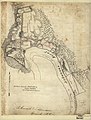 (Map of Arkansas Post, Ark.) LOC 2006635252.jpg 5,247 × 6,905; 5.29 MB
-
 (Map of Arkansas Post, Ark.) LOC 2006635252.tif 5,247 × 6,905; 103.66 MB
-
 (Sketch of Public Surveys in) Arkansas - DPLA - 743053f29724a083eb9d075d87245f31.jpg 5,596 × 5,637; 2.1 MB
-
 1881 Southwestern Immigration Company.jpg 5,107 × 5,485; 2.95 MB
-
 1911 Britannica - Arkansas.png 1,000 × 742; 965 KB
-

-
 A new map of Arkansas LOC 2018588057.jpg 8,951 × 7,520; 9.76 MB
-
 A new map of Arkansas LOC 2018588057.tif 8,951 × 7,520; 192.58 MB
-
 A new map of Arkansas with its canals, roads, & distances. LOC 88691883.jpg 3,255 × 4,203; 1.69 MB
-
 A new map of Arkansas with its canals, roads, & distances. LOC 88691883.tif 3,255 × 4,203; 39.14 MB
-
 Albert Pike Recreation Area, Ouachita National Forest LOC 2013592240.jpg 3,663 × 5,454; 2.34 MB
-
 Albert Pike Recreation Area, Ouachita National Forest LOC 2013592240.tif 3,663 × 5,454; 57.16 MB
-
 Annual Reports of the Department of the Interior 1905 (1905) (14597932840).jpg 2,860 × 2,146; 1.15 MB
-
 Annual Reports of the Department of the Interior 1905 (1905) (14784356812).jpg 3,234 × 4,554; 2.37 MB
-

-

-

-
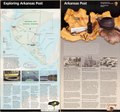
 Arkansas Post National Memorial, Arkansas LOC 2001623225.jpg 5,039 × 4,721; 3.77 MB
-
 Arkansas Post National Memorial, Arkansas LOC 2001623225.tif 5,039 × 4,721; 68.06 MB
-
 Arkansas Post National Memorial, Arkansas LOC 2003682967.jpg 5,000 × 4,725; 3.96 MB
-
 Arkansas Post National Memorial, Arkansas LOC 2003682967.tif 5,000 × 4,725; 67.59 MB
-
 Arkansas Post National Memorial, Arkansas LOC 2006458464.jpg 5,056 × 4,721; 3.94 MB
-
 Arkansas Post National Memorial, Arkansas LOC 2006458464.tif 5,056 × 4,721; 68.29 MB
-
 Arkansas Post National Memorial, Arkansas LOC 2010592137.jpg 5,063 × 4,718; 4.43 MB
-
 Arkansas Post National Memorial, Arkansas LOC 2010592137.tif 5,063 × 4,718; 68.34 MB
-
 Arkansas Post National Memorial, Arkansas LOC 91684878.jpg 7,892 × 4,225; 4.71 MB
-
 Arkansas Post National Memorial, Arkansas LOC 91684878.tif 7,892 × 4,225; 95.4 MB
-
 Arkansas River and tributaries- Part 1. LOC gm70002188.jpg 8,509 × 5,153; 4.86 MB
-
 Arkansas River and tributaries- Part 1. LOC gm70002188.tif 8,509 × 5,153; 125.45 MB
-
 Arkansas River and tributaries. LOC gm69003396.jpg 8,505 × 5,115; 4.66 MB
-
 Arkansas River and tributaries. LOC gm69003396.tif 8,505 × 5,115; 124.46 MB
-
 Arkansas, major land resources area LOC 2013592239.jpg 5,161 × 3,331; 2.11 MB
-
 Arkansas, major land resources area LOC 2013592239.tif 5,161 × 3,331; 49.18 MB
-

-

-
 Arkansas; county subdivisions, townships and places. 1970. LOC gm72003045.jpg 8,480 × 9,338; 6.44 MB
-
 Arkansas; county subdivisions, townships and places. 1970. LOC gm72003045.tif 8,480 × 9,338; 226.55 MB
-
 Beaver Lake, Arkansas. LOC 77695704.jpg 12,377 × 7,255; 12.04 MB
-
 Beaver Lake, Arkansas. LOC 77695704.tif 12,377 × 7,255; 256.91 MB
-
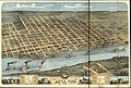 Bird's eye view of the city of Little Rock, the capitol of Arkansas 1871. LOC 73693338.jpg 10,496 × 7,072; 16.99 MB
-

-
 Blanchard Springs Caverns and the Sylamore Ranger District Ozark National Forest LOC 2002630235.tif 9,572 × 5,165; 141.45 MB
-
 Blanchard Springs Caverns in the Sylamore District, Ozark National Forest LOC 96681167.jpg 9,631 × 5,417; 8.23 MB
-
 Blanchard Springs Caverns in the Sylamore District, Ozark National Forest LOC 96681167.tif 9,631 × 5,417; 149.26 MB
-
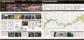
 Buffalo National River - official map and guide LOC 2001623220.jpg 10,056 × 4,730; 6.79 MB
-
 Buffalo National River - official map and guide LOC 2001623220.tif 10,056 × 4,730; 136.08 MB
-
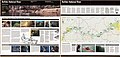
 Buffalo National River - official map and guide LOC 2003629343.jpg 10,039 × 4,739; 7.01 MB
-
 Buffalo National River - official map and guide LOC 2003629343.tif 10,039 × 4,739; 136.11 MB
-
 Buffalo National River - official map and guide LOC 88691573.jpg 10,074 × 4,762; 7.67 MB
-
 Buffalo National River - official map and guide LOC 88691573.tif 10,074 × 4,762; 137.25 MB
-
 Buffalo National River - official map and guide LOC 89695065.jpg 10,039 × 4,762; 7.78 MB
-
 Buffalo National River - official map and guide LOC 89695065.tif 10,039 × 4,762; 136.77 MB
-
 Buffalo National River - official map and guide LOC 90684109.jpg 10,039 × 4,749; 7.65 MB
-
 Buffalo National River - official map and guide LOC 90684109.tif 10,039 × 4,749; 136.4 MB
-
 Buffalo National River - official map and guide LOC 91684723.jpg 10,039 × 4,744; 6.76 MB
-
 Buffalo National River - official map and guide LOC 91684723.tif 10,039 × 4,744; 136.26 MB
-
 Buffalo National River - official map and guide LOC 93684151.jpg 10,040 × 4,746; 7.03 MB
-
 Buffalo National River - official map and guide LOC 93684151.tif 10,040 × 4,746; 136.33 MB
-
 Buffalo National River - official map and guide LOC 97684191.jpg 10,056 × 4,728; 6.99 MB
-
 Buffalo National River - official map and guide LOC 97684191.tif 10,056 × 4,728; 136.03 MB
-

-

-
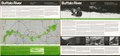
 Buffalo National River, Arkansas LOC 2010586246.jpg 10,039 × 4,750; 6.98 MB
-
 Buffalo National River, Arkansas LOC 2010586246.tif 10,039 × 4,750; 136.43 MB
-
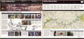
 Buffalo National River, Arkansas LOC 2014589383.jpg 10,074 × 4,742; 6.93 MB
-
 Buffalo National River, Arkansas LOC 2014589383.tif 10,074 × 4,742; 136.67 MB
-
 Buffalo National River, official map and guide LOC 2006627012.jpg 10,039 × 4,741; 6.57 MB
-
 Buffalo National River, official map and guide LOC 2006627012.tif 10,039 × 4,741; 136.17 MB
-
 Buffalo River, National River, Arkansas LOC 79691562.jpg 9,989 × 4,720; 8.15 MB
-
 Buffalo River, National River, Arkansas LOC 79691562.tif 9,989 × 4,720; 134.89 MB
-
 Buffalo River, national river, Arkansas LOC 80691752.jpg 10,036 × 4,710; 8.05 MB
-
 Buffalo River, national river, Arkansas LOC 80691752.tif 10,036 × 4,710; 135.24 MB
-
 Buffalo River, national river, Arkansas LOC 85696001.jpg 10,036 × 4,742; 8.38 MB
-
 Buffalo River, national river, Arkansas LOC 85696001.tif 10,036 × 4,742; 136.16 MB
-
 Buffalo River, national river, Arkansas LOC 86694141.jpg 10,005 × 4,775; 7.93 MB
-
 Buffalo River, national river, Arkansas LOC 86694141.tif 10,005 × 4,775; 136.68 MB
-
 Buffalo River, National River, Arkansas LOC 86694214.jpg 10,036 × 4,708; 8.53 MB
-
 Buffalo River, National River, Arkansas LOC 86694214.tif 10,036 × 4,708; 135.18 MB
-
 Buffalo River, national river, Arkansas LOC 87692865.jpg 10,039 × 4,748; 7.67 MB
-
 Buffalo River, national river, Arkansas LOC 87692865.tif 10,039 × 4,748; 136.37 MB
-
 Bull Shoals dam and reservoir. LOC 2014589252.jpg 10,281 × 5,452; 8.22 MB
-
 Bull Shoals dam and reservoir. LOC 2014589252.tif 10,281 × 5,452; 160.37 MB
-
 Bull Shoals Lake, Arkansas and Missouri LOC 90684003.jpg 7,214 × 10,286; 10.99 MB
-
 Bull Shoals Lake, Arkansas and Missouri LOC 90684003.tif 7,214 × 10,286; 212.3 MB
-
 Calhoun County, Arknasas LOC 2011590023.jpg 9,066 × 12,615; 14.08 MB
-
 Climatological data, Arkansas (1942) (14589843140).jpg 3,008 × 2,654; 915 KB
-
 Climatological data, Arkansas (1942) (14589983510).jpg 3,088 × 2,724; 1,015 KB
-
 Climatological data, Arkansas (1942) (14753620936).jpg 3,088 × 2,732; 945 KB
-

-

-

-

-

-
 County map of the state of Arkansas, Mississippi, and Louisiana. (8971836375).jpg 4,622 × 7,213; 5.28 MB
-

-

-

-

-

-

-
 Early action, USDA projects, Ouachita River Basin, Arkansas and Louisiana LOC 81692252.jpg 3,139 × 5,803; 1.59 MB
-
 Early action, USDA projects, Ouachita River Basin, Arkansas and Louisiana LOC 81692252.tif 3,139 × 5,803; 52.12 MB
-
 EB9 Arkansas - map.jpg 3,665 × 2,673; 1.85 MB
-
 EB9 Arkansas - sketch map.jpg 1,220 × 1,276; 237 KB
-

-
-

-

-
 Excerpt of map showing former location of Columbia Arkansas with note "burned in 1864".jpg 2,511 × 2,511; 1.33 MB
-
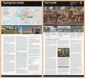
 Fort Smith LOC 84696033.jpg 5,476 × 5,025; 4.23 MB
-
 Fort Smith LOC 84696033.tif 5,476 × 5,025; 78.73 MB
-
 Fort Smith LOC 93684433.jpg 5,587 × 5,077; 4.36 MB
-
 Fort Smith LOC 93684433.tif 5,587 × 5,077; 81.15 MB
-
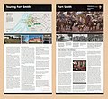 Fort Smith National Historic Site, Arkansas LOC 2008621526.jpg 5,627 × 5,141; 4.2 MB
-
 Fort Smith National Historic Site, Arkansas LOC 2010592509.jpg 5,639 × 5,068; 4.15 MB
-
 Fort Smith National Historic Site, Arkansas LOC 2010592509.tif 5,639 × 5,068; 81.76 MB
-
 Fort Smith, Fort Smith National Historic Site LOC 2002626315.jpg 5,520 × 5,055; 4.11 MB
-
 Fort Smith, Fort Smith National Historic Site LOC 2002626315.tif 5,520 × 5,055; 79.83 MB
-
 Fort Smith, Fort Smith National Historic Site LOC 2003629360.jpg 5,476 × 5,016; 4.19 MB
-
 Fort Smith, Fort Smith National Historic Site LOC 2003629360.tif 5,476 × 5,016; 78.59 MB
-
 Fort Smith, Fort Smith National Historic Site LOC 2005627249.jpg 5,663 × 5,098; 3.99 MB
-
 Fort Smith, Fort Smith National Historic Site LOC 2005627249.tif 5,663 × 5,098; 82.6 MB
-
 Fort Smith, Fort Smith National Historic Site LOC 2007630098.jpg 5,175 × 4,795; 3.65 MB
-
 Fort Smith, Fort Smith National Historic Site LOC 2007630098.tif 5,175 × 4,795; 70.99 MB
-
 Fort Smith, Fort Smith National Historic Site LOC 2011590575.jpg 5,460 × 5,008; 4.02 MB
-
 Fort Smith, Fort Smith National Historic Site LOC 2011590575.tif 5,460 × 5,008; 78.23 MB
-

-

-

-
-
 General soil map, Arkansas County, Arkansas LOC 83695272.jpg 5,545 × 7,167; 4.05 MB
-
 General soil map, Arkansas County, Arkansas LOC 83695272.tif 5,545 × 7,167; 113.7 MB
-

-

-

-

-
 General soil map, Calhoun County, Arkansas LOC 83693127.jpg 5,526 × 7,146; 3.55 MB
-
 General soil map, Calhoun County, Arkansas LOC 83693127.tif 5,526 × 7,146; 112.98 MB
-
 General soil map, Crawford County, Arkansas LOC 83695283.jpg 7,339 × 5,648; 3.98 MB
-
 General soil map, Crawford County, Arkansas LOC 83695283.tif 7,339 × 5,648; 118.59 MB
-
 General soil map, Crittenden County, Arkansas LOC 83695281.jpg 7,233 × 5,588; 4.21 MB
-
 General soil map, Crittenden County, Arkansas LOC 83695281.tif 7,233 × 5,588; 115.64 MB
-

-

-
 General soil map, Franklin County, Arkansas LOC 81692332.jpg 7,232 × 5,562; 3.42 MB
-
 General soil map, Franklin County, Arkansas LOC 81692332.tif 7,232 × 5,562; 115.08 MB
-
 General soil map, Fulton County, Arkansas LOC 83695275.jpg 7,254 × 5,608; 4.13 MB
-
 General soil map, Fulton County, Arkansas LOC 83695275.tif 7,254 × 5,608; 116.39 MB
-
 General soil map, Greene County, Arkansas LOC 83695277.tif 7,495 × 5,534; 118.67 MB
-
 General soil map, Izard County, Arkansas LOC 83693121.jpg 7,189 × 5,521; 3.69 MB
-
 General soil map, Izard County, Arkansas LOC 83693121.tif 7,189 × 5,521; 113.56 MB
-
 General soil map, Johnson County, Arkansas LOC 83693134.tif 7,172 × 5,510; 113.06 MB
-
 General soil map, Lee County, Arkansas LOC 83695276.jpg 7,483 × 5,538; 4.07 MB
-
 General soil map, Lee County, Arkansas LOC 83695276.tif 7,483 × 5,538; 118.56 MB
-
 General soil map, Mississippi County, Arkansas LOC 83695280.jpg 7,470 × 5,533; 4.81 MB
-
 General soil map, St. Francis County, Arkansas LOC 83695278.jpg 7,493 × 5,549; 4.25 MB
-
 General soil map, St. Francis County, Arkansas LOC 83695278.tif 7,493 × 5,549; 118.96 MB
-

-

-

-

-

-

-
 Geological map of southern Arkansas and adjacent regions LOC 94680865.jpg 4,277 × 3,654; 1.92 MB
-
 Geological map of southern Arkansas and adjacent regions LOC 94680865.tif 4,277 × 3,654; 44.71 MB
-

-
 Greers Ferry Lake, Arkansas LOC 82691818.jpg 7,224 × 10,286; 10.23 MB
-
 Greers Ferry Lake, Arkansas LOC 82691818.tif 7,224 × 10,286; 212.59 MB
-

-

-

-

-
 Hot Springs National Park, Arkansas LOC 2001623217.jpg 10,615 × 5,113; 8.03 MB
-
 Hot Springs National Park, Arkansas LOC 2001623217.tif 10,615 × 5,113; 155.28 MB
-
 Hot Springs National Park, Arkansas LOC 2002627162.jpg 10,494 × 5,119; 8.1 MB
-
 Hot Springs National Park, Arkansas LOC 2002627162.tif 10,494 × 5,119; 153.69 MB
-
 Hot Springs National Park, Arkansas LOC 2005627246.jpg 10,585 × 5,055; 7.97 MB
-
 Hot Springs National Park, Arkansas LOC 2005627246.tif 10,585 × 5,055; 153.09 MB
-
 Hot Springs National Park, Arkansas LOC 2006636000.jpg 10,518 × 5,072; 8.16 MB
-
 Hot Springs National Park, Arkansas LOC 2006636000.tif 10,518 × 5,072; 152.63 MB
-
 Hot Springs National Park, Arkansas LOC 2010586247.jpg 10,499 × 5,024; 8.52 MB
-
 Hot Springs National Park, Arkansas LOC 2010586247.tif 10,499 × 5,024; 150.91 MB
-
 Hot Springs National Park, Arkansas LOC 2011590438.jpg 10,547 × 5,064; 7.96 MB
-
 Hot Springs National Park, Arkansas LOC 2011590438.tif 10,547 × 5,064; 152.81 MB
-
 Hot Springs National Park, Arkansas LOC 88691784.jpg 5,316 × 7,423; 6.65 MB
-
 Hot Springs National Park, Arkansas LOC 88691784.tif 5,316 × 7,423; 112.9 MB
-
 Hot Springs National Park, Arkansas LOC 91684627.jpg 10,500 × 5,046; 8.51 MB
-
 Hot Springs National Park, Arkansas LOC 91684627.tif 10,500 × 5,046; 151.59 MB
-
 Hot Springs National Park, Arkansas LOC 92684624.jpg 10,594 × 5,113; 8.19 MB
-
 Hot Springs National Park, Arkansas LOC 92684624.tif 10,594 × 5,113; 154.97 MB
-
 Hot Springs National Park, Arkansas LOC 93682890.jpg 10,530 × 5,008; 8.45 MB
-
 Hot Springs National Park, Arkansas LOC 93682890.tif 10,530 × 5,008; 150.87 MB
-
 Hot Springs National Park, Arkansas LOC 95685016.jpg 10,350 × 4,956; 8.22 MB
-
 Hot Springs National Park, Arkansas LOC 95685016.tif 10,350 × 4,956; 146.76 MB
-
 Hot Springs National Park, Arkansas LOC 97684162.jpg 10,449 × 5,027; 8.35 MB
-
 Hot Springs National Park, Arkansas LOC 97684162.tif 10,449 × 5,027; 150.28 MB
-
 Hot Springs National Park, Arkansas LOC 98684183.jpg 10,547 × 5,087; 8.12 MB
-
 Hot Springs National Park, Arkansas LOC 98684183.tif 10,547 × 5,087; 153.5 MB
-
 Hot Springs National Park. Dec. 1965. LOC 73695970.jpg 4,279 × 7,251; 3.97 MB
-
 Hot Springs National Park. Dec. 1965. LOC 73695970.tif 4,279 × 7,251; 88.77 MB
_LOC_2006635252.jpg)
_Arkansas_-_DPLA_-_743053f29724a083eb9d075d87245f31.jpg)


.jpg)


_(14597932840).jpg)
_(14784356812).jpg)
.jpg)


_(14589843140).jpg)
_(14589983510).jpg)
_(14753620936).jpg)
_(14597556219).jpg)


.jpg)


,_Arkansas-White-Red_River_basin_-_Colfax,_Curry,_Guadalupe,_Harding,_Mora,_Quay,_San_Miguel,_and_Union_counties,_New_Mexico._LOC_2003621386.jpg)


