Category:Old maps of New Hampshire
States of the United States: Alabama · Alaska · Arizona · Arkansas · California · Colorado · Connecticut · Delaware · Florida · Georgia · Hawaii · Idaho · Illinois · Indiana · Iowa · Kansas · Kentucky · Louisiana · Maine · Maryland · Massachusetts · Michigan · Minnesota · Mississippi · Missouri · Montana · Nebraska · Nevada · New Hampshire · New Jersey · New Mexico · New York · North Carolina · North Dakota · Ohio · Oklahoma · Oregon · Pennsylvania · Rhode Island · South Carolina · South Dakota · Tennessee · Texas · Utah · Vermont · Virginia · Washington · West Virginia · Wisconsin · Wyoming – District of Columbia: Washington, D.C.
Guam · Northern Mariana Islands · Puerto Rico
Guam · Northern Mariana Islands · Puerto Rico
Subcategories
This category has the following 13 subcategories, out of 13 total.
S
Media in category "Old maps of New Hampshire"
The following 139 files are in this category, out of 139 total.
-
 10 of 'History of New England. vol. 1-4' (11054440816).jpg 2,672 × 1,545; 1.05 MB
-

-

-

-
 18 of 'Rhymes of the States. With drawings, etc' (11300880836).jpg 1,211 × 1,298; 230 KB
-
 1940 12 20 isoseismal map.PNG 646 × 531; 59 KB
-

-

-

-

-

-

-

-

-

-

-
-

-

-

-

-

-

-

-
-

-

-
 A map of New Hampshire. NYPL1567520.tiff 5,428 × 6,598; 102.47 MB
-

-

-
 A topographical map of the state of New Hampshire (2675129207).jpg 1,466 × 2,000; 2.22 MB
-
 A topographical map of the State of New Hampshire (9472186401).jpg 646 × 800; 89 KB
-
 Arbuckle Bros. Coffee Company (3093001283).jpg 799 × 481; 310 KB
-
 Belknap County, New Hampshire LOC 81690022.jpg 4,736 × 5,939; 2.71 MB
-
 Belknap County, New Hampshire LOC 81690022.tif 4,736 × 5,939; 80.47 MB
-
 Belknap County, New Hampshire LOC 81690124.jpg 7,177 × 7,224; 4.01 MB
-
 Belknap County, New Hampshire LOC 81690124.tif 7,177 × 7,224; 148.33 MB
-
 Bird's eye view of Portsmouth, Rockingham Co., New Hampshire. LOC 77693545.jpg 8,463 × 6,671; 11.47 MB
-
 Britannica New Hampshire and Vermont.jpg 1,961 × 2,645; 3.22 MB
-
 Carroll County, New Hampshire LOC 81690020.jpg 5,380 × 8,923; 4.97 MB
-
 Carroll County, New Hampshire LOC 81690020.tif 5,380 × 8,923; 137.35 MB
-
 Carroll County, New Hampshire LOC 81690123.jpg 7,163 × 7,209; 3.92 MB
-
 Carroll County, New Hampshire LOC 81690123.tif 7,163 × 7,209; 147.74 MB
-
 Coos County, New Hampshire LOC 81690120.jpg 6,576 × 8,041; 3.94 MB
-
 Coos County, New Hampshire LOC 81690120.tif 6,576 × 8,041; 151.28 MB
-
 Diagram of the south part of Shaker Village, Canterbury, NH. LOC 00552211.jpg 3,709 × 4,839; 2.27 MB
-
 Diagram of the south part of Shaker Village, Canterbury, NH. LOC 00552211.tif 3,709 × 4,839; 51.35 MB
-
 EB9 New Hampshire.jpg 2,674 × 3,733; 1.85 MB
-

-

-
 Hillsborough County, New Hampshire LOC 81690126.jpg 7,151 × 7,124; 4.58 MB
-
 Hillsborough County, New Hampshire LOC 81690126.tif 7,151 × 7,124; 145.75 MB
-
 J. H. Colton's School Atlas, 1860 - DPLA - 9afa4d40de861bb7b2a7e024bba61c0e (page 13).jpg 4,093 × 4,953; 2.28 MB
-
 Manuscript map of coast from Maine to Delaware (2674786657).jpg 2,000 × 1,696; 2.33 MB
-
 Map of Cheshire Co., New Hampshire LOC 2012587747.jpg 17,321 × 17,388; 39.35 MB
-
 Map of Keene, Cheshire Co., N.H. LOC 2011589223.jpg 10,331 × 12,832; 11.71 MB
-
 Map of Keene, Cheshire Co., N.H. LOC 2011589223.tif 10,331 × 12,832; 379.28 MB
-
-
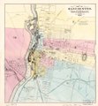
 Map of Manchester, N.H. - compiled by Joseph B. Sawyer, C.E. LOC 2011592152.jpg 5,822 × 5,997; 5.1 MB
-
 Map of Manchester, N.H. - compiled by Joseph B. Sawyer, C.E. LOC 2011592152.tif 5,822 × 5,997; 99.89 MB
-
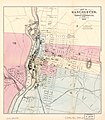
 Map of Manchester. LOC 2011592153.jpg 4,273 × 4,626; 3.16 MB
-
 Map of Manchester. LOC 2011592153.tif 4,273 × 4,626; 56.55 MB
-
 Map of Manchester. LOC 2011592154.jpg 4,196 × 4,790; 3 MB
-
 Map of Manchester. LOC 2011592154.tif 4,196 × 4,790; 57.5 MB
-
 Map of Milford, Hillsboro' Co., New Hampshire LOC 2009579135.jpg 14,471 × 11,573; 21.91 MB
-
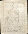
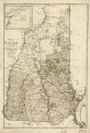
 Map of New Hampshire 1768.jpg 950 × 711; 229 KB
-
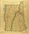 Map of New Hampshire and Vermont.jpg 2,933 × 3,443; 2.69 MB
-

-

-
 Map of Rockingham Co., New Hampshire LOC 2012593011.jpg 16,953 × 17,221; 40.82 MB
-
 Map of Rockingham Co., New Hampshire LOC 2012593011.tif 16,953 × 17,221; 835.27 MB
-
 Map of southern New Hampshire LOC 2006628389.jpg 10,121 × 7,264; 9.79 MB
-
 Map of southern New Hampshire LOC 2006628389.tif 10,121 × 7,264; 210.34 MB
-
-
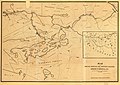
 Map of the Boston, Concord and Montreal Railroad from Concord to Haverhill, N.H. LOC gm70005004.tif 11,087 × 7,853; 249.1 MB
-

-

-

-
 Map of the town of Canaan N.H. Grafton Co. (6093625017).jpg 2,000 × 1,324; 2.03 MB
-
 Map of the town of Dublin, N.H. (7537848720).jpg 2,000 × 1,654; 2.76 MB
-

-
 Merrimack County, New Hampshire LOC 81690121.jpg 7,166 × 7,220; 4.39 MB
-
 Merrimack County, New Hampshire LOC 81690121.tif 7,166 × 7,220; 148.03 MB
-
 Milford, N.H. LOC 75694695.jpg 8,112 × 4,832; 7.86 MB
-
 Milford, N.H. LOC 75694695.tif 8,112 × 4,832; 112.14 MB
-
 New Hampshire (4587187758).jpg 2,000 × 1,233; 3.57 MB
-
 New Hampshire and Vermont LOC 83692118.jpg 6,542 × 8,175; 5.96 MB
-
 New Hampshire and Vermont LOC 83692118.tif 6,542 × 8,175; 153.01 MB
-
 New Hampshire LOC 2011589275.jpg 7,699 × 11,306; 10.91 MB
-
 New Hampshire LOC 2011589275.tif 7,699 × 11,306; 249.04 MB
-
 New Hampshire LOC 85695374.jpg 5,116 × 7,549; 2.69 MB
-
 New Hampshire LOC 85695374.tif 5,116 × 7,549; 110.49 MB
-
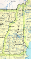 New Hampshire map.png 430 × 799; 675 KB
-
 New Hampshire organizational map LOC 81692938.jpg 2,542 × 3,296; 983 KB
-
 New Hampshire organizational map LOC 81692938.tif 2,542 × 3,296; 23.97 MB
-
 New Hampshire. LOC 79694562.jpg 7,588 × 12,234; 9.74 MB
-
 New Hampshire. LOC 79694562.tif 7,588 × 12,234; 265.59 MB
-
 New-Hampshire - from late survey LOC 78692906.jpg 6,026 × 9,552; 9.92 MB
-
 New Hampshire and Vermont (NYPL b13663520-1510798).tiff 5,246 × 6,298; 95.19 MB
-
 A map of New Hampshire (NYPL b14115138-1567520).jpg 5,428 × 6,598; 4.44 MB
-
 Penacook, N.H. LOC 75694697.jpg 8,256 × 5,328; 8.21 MB
-
 Penacook, N.H. LOC 75694697.tif 8,256 × 5,328; 125.85 MB
-
 Plan du port de Portsmouth levé à vue. LOC gm71000981.jpg 4,769 × 3,718; 1.61 MB
-
 Plan du port de Portsmouth levé à vue. LOC gm71000981.tif 4,769 × 3,718; 50.73 MB
-
 Plan of Exeter village, New Hampshire LOC 2008624187.jpg 6,653 × 8,377; 5.55 MB
-
 Plan of Exeter village, New Hampshire LOC 2008624187.tif 6,653 × 8,377; 159.45 MB
-
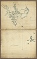
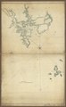
 Plan of the town of Stratham LOC 97683083.jpg 2,516 × 3,159; 1.54 MB
-
 Plan of the town of Stratham LOC 97683083.tif 2,516 × 3,159; 22.74 MB
-

-

-
 Project map, Baker River watershed, Grafton County, New Hampshire LOC 81690286.jpg 2,539 × 3,152; 1,017 KB
-
 Project map, Baker River watershed, Grafton County, New Hampshire LOC 81690286.tif 2,539 × 3,152; 22.9 MB
-
 Reconnaissance erosion survey of the States of New-Hampshire and Vermont - btv1b531894871.jpg 7,056 × 10,008; 6.69 MB
-

-
 Recreation facility map, White Mountain National Forest, New Hampshire and Maine LOC 78695352.tif 9,503 × 9,500; 258.29 MB
-
 Rockingham County, New Hampshire LOC 81690125.jpg 7,180 × 7,236; 4.18 MB
-
 Rockingham County, New Hampshire LOC 81690125.tif 7,180 × 7,236; 148.64 MB
-
 Rockingham County, New Hampshire LOC 86693406.jpg 8,801 × 7,212; 6.79 MB
-
 Rockingham County, New Hampshire LOC 86693406.tif 8,801 × 7,212; 181.6 MB
-
 Salmon Falls, Strafford Co., New Hampshire 1877. LOC 73694812.jpg 4,280 × 3,528; 3.66 MB
-
 Sea coast of Rockingham County, N.H. LOC 2012587736.jpg 8,201 × 7,095; 6.54 MB
-
 Sea coast of Rockingham County, N.H. LOC 2012587736.tif 8,201 × 7,095; 166.47 MB
-
 Strafford County, New Hampshire LOC 81690023.jpg 3,832 × 6,107; 2.42 MB
-
 Strafford County, New Hampshire LOC 81690023.tif 3,832 × 6,107; 66.95 MB
-
 Strafford County, New Hampshire LOC 81690122.jpg 7,196 × 7,234; 4.22 MB
-
 Strafford County, New Hampshire LOC 81690122.tif 7,196 × 7,234; 148.93 MB
-
 The Granite Monthly Volume 3 - Map of the White Mountains New Hampshire.jpg 2,448 × 2,756; 6.19 MB
-
 The Saint-Gaudens National Historic Site LOC 78696403.jpg 3,696 × 5,592; 2.67 MB
-
 The Saint-Gaudens National Historic Site LOC 78696403.tif 3,696 × 5,592; 59.13 MB
-
 The State of New Hampshire. Compiled chiefly from actual surveys. LOC gm71000983.jpg 3,658 × 5,616; 2.79 MB
-
 The State of New Hampshire. Compiled chiefly from actual surveys. LOC gm71000983.tif 3,658 × 5,616; 58.78 MB
-
 Topographical map of Carroll County, New Hampshire LOC 2012587750.jpg 16,704 × 16,450; 43.63 MB
-
 Trails of Mt. Monadnock. LOC 76692217.jpg 6,526 × 3,957; 3.64 MB
-
 Transportation map of New Hampshire and Vermont. LOC 77694799.jpg 4,954 × 6,489; 3.49 MB
-
 Transportation map of New Hampshire and Vermont. LOC 77694799.tif 4,954 × 6,489; 91.97 MB
-
 Transportation map of New Hampshire and Vermont. LOC 77694842.jpg 4,899 × 6,452; 3.6 MB
-
 Transportation map of New Hampshire and Vermont. LOC 77694842.tif 4,899 × 6,452; 90.43 MB
-
 Vermont and New Hampshire. NYPL1401776.tiff 4,848 × 5,475; 75.96 MB
-
 What to see in America (1919) (14782949202).jpg 1,864 × 3,052; 809 KB
.jpg)
_C._H._Hitchcock,_State_Geologist,_J._H._Huntington,_Principal_Assistant%27_(11107460605).jpg)
_C._H._Hitchcock,_State_Geologist,_J._H._Huntington,_Principal_Assistant%27_(11107641943).jpg)
_C._H._Hitchcock,_State_Geologist,_J._H._Huntington,_Principal_Assistant%27_(11106325514).jpg)
.jpg)

_C._H._Hitchcock,_State_Geologist,_J._H._Huntington,_Principal_Assistant%27_(11107656746).jpg)
_C._H._Hitchcock,_State_Geologist,_J._H._Huntington,_Principal_Assistant%27_(11104290054).jpg)
_C._H._Hitchcock,_State_Geologist,_J._H._Huntington,_Principal_Assistant%27_(11105237296).jpg)
_C._H._Hitchcock,_State_Geologist,_J._H._Huntington,_Principal_Assistant%27_(11106107056).jpg)
._1719-1883_..._With_the_history_and_genealogy_of_its_first_settlers_and_their_descendants,_etc%27_(11162093254).jpg)
_C._H._Hitchcock,_State_Geologist,_J._H._Huntington,_Principal_Assistant%27_(11104613044).jpg)
_C._H._Hitchcock,_State_Geologist,_J._H._Huntington,_Principal_Assistant%27_(11106955054).jpg)
_C._H._Hitchcock,_State_Geologist,_J._H._Huntington,_Principal_Assistant%27_(11104638706).jpg)
_C._H._Hitchcock,_State_Geologist,_J._H._Huntington,_Principal_Assistant%27_(11107213614).jpg)
%27_(11222231674).jpg)
.jpg)
_C._H._Hitchcock,_State_Geologist,_J._H._Huntington,_Principal_Assistant%27_(11106219363).jpg)
_C._H._Hitchcock,_State_Geologist,_J._H._Huntington,_Principal_Assistant%27_(11104984993).jpg)
_C._H._Hitchcock,_State_Geologist,_J._H._Huntington,_Principal_Assistant%27_(11103977085).jpg)
_C._H._Hitchcock,_State_Geologist,_J._H._Huntington,_Principal_Assistant%27_(11103629015).jpg)
_C._H._Hitchcock,_State_Geologist,_J._H._Huntington,_Principal_Assistant%27_(11106082956).jpg)
_C._H._Hitchcock,_State_Geologist,_J._H._Huntington,_Principal_Assistant%27_(11107661975).jpg)
_C._H._Hitchcock,_State_Geologist,_J._H._Huntington,_Principal_Assistant%27_(11107222504).jpg)
_C._H._Hitchcock,_State_Geologist,_J._H._Huntington,_Principal_Assistant%27_(11107640645).jpg)
_C._H._Hitchcock,_State_Geologist,_J._H._Huntington,_Principal_Assistant%27_(11105838683).jpg)
.jpg)
.jpg)
.jpg)
.jpg)
.jpg)
.jpg)


.jpg)
.jpg)


.jpg)


.jpg)
.jpg)
.jpg)
_and_Boston_from_Concord_%26_Manchester,_N.H_(8346292853).jpg)


.jpg)


.jpg)


_(14767161072).jpg)


_(14782949202).jpg)
.jpg)