Category:Old maps of Missouri
States of the United States: Alabama · Alaska · Arizona · Arkansas · California · Colorado · Connecticut · Delaware · Florida · Georgia · Hawaii · Idaho · Illinois · Indiana · Iowa · Kansas · Kentucky · Louisiana · Maine · Maryland · Massachusetts · Michigan · Minnesota · Mississippi · Missouri · Montana · Nebraska · Nevada · New Hampshire · New Jersey · New Mexico · New York · North Carolina · North Dakota · Ohio · Oklahoma · Oregon · Pennsylvania · Rhode Island · South Carolina · South Dakota · Tennessee · Texas · Utah · Vermont · Virginia · Washington · West Virginia · Wisconsin · Wyoming – District of Columbia: Washington, D.C.
Guam · Northern Mariana Islands · Puerto Rico
Guam · Northern Mariana Islands · Puerto Rico
Subcategories
This category has the following 36 subcategories, out of 36 total.
C
O
S
Media in category "Old maps of Missouri"
The following 155 files are in this category, out of 155 total.
-
-

-

-
 1827 Finley Map of Missouri - Geographicus - Missouri-finley-1827.jpg 2,337 × 3,000; 1.66 MB
-
 1850 Land Survey Map of Missouri - Geographicus - MO-ls-1850.jpg 2,800 × 2,216; 1.18 MB
-
 1855 Colton Map of Missouri - Geographicus - Missouri-colton-1855.jpg 4,000 × 3,310; 3.79 MB
-

-

-
 1874 Johnson Map of Missouri and Kansas - Geographicus - MIKA2-johnson-1864.jpg 5,000 × 3,808; 7.59 MB
-

-

-

-

-
-

-

-

-

-
-

-

-

-
 Annual report of the State Horticultural Society of Missouri BHL5139934.jpg 3,456 × 2,124; 652 KB
-

-

-

-
 Aurora, Missouri 1891. LOC 75693041.jpg 9,216 × 6,272; 9.96 MB
-

-

-
 Battle grounds in Missouri during Price's raid in the fall 1864 LOC 99447438.jpg 3,511 × 4,238; 1.79 MB
-
 Battle grounds in Missouri during Price's raid in the fall 1864 LOC 99447438.tif 3,511 × 4,238; 42.57 MB
-
 Bird's eye view of the city of Independence, Jackson Co., Missouri 1868. LOC 73693478.jpg 8,704 × 6,976; 10.64 MB
-
 Bird's eye view of the city of Saint Joseph, Missouri 1868. LOC 73693489.jpg 8,912 × 6,992; 14.17 MB
-

-

-
 Bulletin (1910) (20235506348).jpg 1,614 × 2,916; 660 KB
-
 City of Louisiana, Pike County, Missouri - NARA - 100306171.jpg 11,464 × 10,264; 12.41 MB
-
 City of St. Louis LOC 2005625348.jpg 8,177 × 5,756; 7.44 MB
-
 City of St. Louis LOC 2005625348.tif 8,177 × 5,756; 134.66 MB
-
 Collier's 1921 Missouri.jpg 2,282 × 1,899; 1.2 MB
-
-

-
 EB1911 Missouri.jpg 2,592 × 1,887; 2.8 MB
-
 EB9 Missouri.jpg 3,721 × 2,897; 1.92 MB
-

-

-
 Hannibal & St. Joseph Railway & connections. LOC 98688676.jpg 2,207 × 1,668; 716 KB
-
 Hannibal & St. Joseph Railway & connections. LOC 98688676.tif 2,207 × 1,668; 10.53 MB
-
 Historical Map of Cass County, Missouri.jpg 945 × 823; 806 KB
-
 Lloyd's official map of Missouri LOC 99448361.jpg 10,014 × 8,112; 9.63 MB
-
 Lloyd's official map of Missouri LOC 99448361.tif 10,014 × 8,112; 232.41 MB
-
 Lloyd's official map of Missouri LOC 99448362.jpg 8,956 × 7,764; 10.85 MB
-
 Lloyd's official map of Missouri LOC 99448362.tif 8,956 × 7,764; 198.94 MB
-

-

-

-
-
 Map and view of St. Louis, Mo. LOC 75694657.jpg 3,448 × 2,816; 1.8 MB
-
 Map and view of St. Louis, Mo. LOC 75694657.tif 3,448 × 2,816; 27.78 MB
-
 Map le of the Mississippi country LOC 2005625349.jpg 8,228 × 4,669; 2.85 MB
-
 Map le of the Mississippi country LOC 2005625349.tif 8,228 × 4,669; 109.91 MB
-
 Map of Buchanan Co, Mo. 1895 LOC 2012593076.jpg 12,187 × 9,491; 19.78 MB
-
 Map of Buchanan Co, Mo. 1895 LOC 2012593076.tif 12,187 × 9,491; 330.93 MB
-
 Map of Cedar Co. Missouri LOC 2012593075.jpg 16,473 × 13,989; 28.25 MB
-
 Map of Cedar Co. Missouri LOC 2012593075.tif 16,473 × 13,989; 659.3 MB
-
 Map of Gundy County, Missouri LOC 2012593039.jpg 13,744 × 15,038; 24.06 MB
-
 Map of Gundy County, Missouri LOC 2012593039.tif 13,744 × 15,038; 591.32 MB
-
 Map of Hickory Co., Mo. LOC 2012593036.jpg 9,113 × 12,223; 15.73 MB
-
 Map of Hickory Co., Mo. LOC 2012593036.tif 9,113 × 12,223; 318.68 MB
-
 Map of Independence, Jackson County, Missouri.jpg 1,234 × 1,526; 1.43 MB
-

-

-
 Map of McDonald County, Missouri- LOC 2012593038.tif 16,111 × 13,108; 604.2 MB
-
 Map of Morgan Co. MO. LOC 2012593043.jpg 11,271 × 8,794; 12.64 MB
-
 Map of Morgan Co. MO. LOC 2012593043.tif 11,271 × 8,794; 283.58 MB
-
 Map of Palmyra, Missouri, 1860.jpg 2,500 × 3,600; 5.21 MB
-
 Map of Pettis County, Missouri, 1872 LOC 2012593079.jpg 3,237 × 4,060; 2.58 MB
-
 Map of Saline County, Missouri LOC 2012593052.jpg 10,767 × 13,179; 22.34 MB
-
 Map of Saline County, Missouri LOC 2012593052.tif 10,767 × 13,179; 405.97 MB
-
 Map of St Louis Wellcome L0040477.jpg 2,296 × 3,948; 3.23 MB
-
 Map of the battlefield near Belmont, Missouri LOC 99447442.jpg 6,617 × 5,514; 4.85 MB
-
 Map of the battlefield near Belmont, Missouri LOC 99447442.tif 6,617 × 5,514; 104.39 MB
-

-

-
 Map of the Lone Star Route.png 1,024 × 3,494; 5.93 MB
-
 Map of the present seat of war in Missouri. LOC 99447440.jpg 6,278 × 4,079; 3.04 MB
-
 Map of the present seat of war in Missouri. LOC 99447440.tif 6,278 × 4,079; 73.27 MB
-

-

-

-
 Map showing the Pacific Railroad of Missouri. LOC 2006626880.jpg 5,911 × 4,204; 3.25 MB
-
 Map showing the Pacific Railroad of Missouri. LOC 2006626880.tif 5,911 × 4,204; 71.1 MB
-
 Maps showing the Atlantic & Pacific Railroad and leased lines. LOC 98688585.jpg 7,584 × 7,200; 14.42 MB
-
 Maps showing the Atlantic & Pacific Railroad and leased lines. LOC 98688585.tif 7,584 × 7,200; 156.23 MB
-
 New commercial and topographical rail road map & guide of Missouri. LOC 98688504.jpg 7,368 × 5,184; 7.57 MB
-
 New commercial and topographical rail road map & guide of Missouri. LOC 98688504.tif 7,368 × 5,184; 109.28 MB
-
 New map of the state of Missouri. LOC 2012593322 (cropped).jpg 4,890 × 3,970; 4.09 MB
-
 New map of the state of Missouri. LOC 2012593322.jpg 5,964 × 3,970; 4.55 MB
-
 New map of the state of Missouri. LOC 2012593322.tif 5,964 × 3,970; 67.74 MB
-
 New topographical map of Saint Louis, Missouri LOC 2012593041.jpg 10,405 × 12,928; 19.59 MB
-
 New topographical map of Saint Louis, Missouri LOC 2012593041.tif 10,405 × 12,928; 384.85 MB
-

-
 Ozarks Highlands of Missouri.png 523 × 474; 186 KB
-
 Pacific, formerly Franklin, Franklin Co., Missouri 1869. LOC 73693485.jpg 3,784 × 3,096; 1.98 MB
-
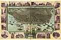
 Panorama of the World's Fair, St Louis, 1904. LOC 97683596.jpg 12,512 × 5,824; 11.42 MB
-
 Panorama of the World's Fair, St Louis, 1904. LOC 97683596.tif 12,512 × 5,824; 208.48 MB
-

-

-
 Panoramic view of the wholesale and office district of St. Louis. LOC 75694665.jpg 3,184 × 1,368; 589 KB
-
 Panoramic view of the wholesale and office district of St. Louis. LOC 75694665.tif 3,184 × 1,368; 12.46 MB
-
 Pen picture of the progress of the city of St. Louis, Mo. LOC 75694658.jpg 8,336 × 6,064; 11.55 MB
-
 Pen picture of the progress of the city of St. Louis, Mo. LOC 75694658.tif 8,336 × 6,064; 144.62 MB
-
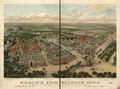
 Pharus-map World's Fair St. Louis, 1904. LOC 99466762.jpg 4,763 × 3,099; 2.56 MB
-
 Pharus-map World's Fair St. Louis, 1904. LOC 99466762.tif 4,763 × 3,099; 42.23 MB
-
 Plan of development for civil works LOC 96683302.jpg 6,545 × 8,632; 4.85 MB
-
 Plan of development for civil works LOC 96683302.tif 6,545 × 8,632; 161.64 MB
-
 Plat of Lone Jack, Missouri.jpg 443 × 976; 319 KB
-
 Raynold Expedition (1869 Case map).jpg 2,310 × 1,533; 494 KB
-
 Raynolds Expedition Map (1869 Base Map).jpg 1,730 × 1,136; 290 KB
-
 Raynolds Expedition Map v1876.jpg 3,331 × 2,648; 1.82 MB
-
-

-

-

-

-

-

-
 Saint Louis in 1896. LOC 75694662.jpg 12,256 × 8,160; 22.31 MB
-
 St. Louis in '93. LOC 75694659.jpg 11,904 × 7,680; 14.38 MB
-
 St. Louis in '93. LOC 75694659.tif 11,904 × 7,680; 261.56 MB
-
 St. Louis in 1895. LOC 75694661.jpg 12,368 × 8,240; 18.07 MB
-
 St. Louis in 1895. LOC 75694661.tif 12,368 × 8,240; 291.57 MB
-
 St. Louis in 1896. LOC 75694663.jpg 12,224 × 7,264; 22.75 MB
-
 St. Louis in 1896. LOC 75694663.tif 12,224 × 7,264; 254.05 MB
-
 State of Missouri And Territory Of Arkansas..jpg 2,326 × 1,887; 901 KB
-
 Strickland's sectional map of Webster Co., Missouri. LOC 2012593048.jpg 3,314 × 5,056; 1.98 MB
-
 Strickland's sectional map of Webster Co., Missouri. LOC 2012593048.tif 3,314 × 5,056; 47.94 MB
-
 T.C. Strickland's new sectional map of Webster Co., Missouri. LOC 2012593049.jpg 3,456 × 5,306; 1.76 MB
-
 T.C. Strickland's new sectional map of Webster Co., Missouri. LOC 2012593049.tif 3,456 × 5,306; 52.46 MB
-

-
 The American midland naturalist (1909) (17970806349).jpg 2,576 × 1,790; 1.36 MB
-
 The hand-book of the Pennsylvania lines (1888) (14736694516).jpg 1,732 × 2,424; 1.06 MB
-
 The heart of St. Louis. LOC 75694666.jpg 7,696 × 6,064; 10.64 MB
-
 The heart of St. Louis. LOC 75694666.tif 7,696 × 6,064; 133.52 MB
-
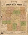 The Maryville Tribune's map of Nodaway County, Missouri. LOC 2012593046.jpg 13,325 × 16,671; 32.85 MB
-
 The panorama of St. Louis. LOC 75694660.jpg 8,096 × 5,664; 5.8 MB
-
 The panorama of St. Louis. LOC 75694660.tif 8,096 × 5,664; 131.19 MB
-
 Transactions (1871) (14768140595).jpg 2,024 × 3,096; 683 KB
-
 Vue de la colonie espagnole du Mississippi en 1802 - carte reduite Haute Louisiane.jpg 1,059 × 1,200; 883 KB
-
 Washington township. LOC 2012593045.jpg 5,238 × 6,430; 5.44 MB
-
 Washington township. LOC 2012593045.tif 5,238 × 6,430; 96.36 MB
-
 World's Fair, St Louis, 1904. LOC 98687180.jpg 11,952 × 8,864; 20.64 MB
-
 World's Fair, St Louis, 1904. LOC 98687180.tif 11,952 × 8,864; 303.1 MB
-

-

.jpg)
.jpg)
.jpg)


%27_(11046044963).jpg)
%27_(11046271414).jpg)
%27_(11047054986).jpg)
%27_(11045587676).jpg)
%27_(11045138826).jpg)
%27_(11045201786).jpg)
%27_(11047087634).jpg)
.jpg)

.jpg)
_(18739567574).jpg)
_(18739573044).jpg)

_(14594773429).jpg)
_(14779077604).jpg)
_(14781073532).jpg)


_(20235506348).jpg)


.jpg)


.jpg)
.jpg)

_(page_160_crop).jpg)


_(14784635142).jpg)
_(17970806349).jpg)
_(14736694516).jpg)


_Fair,_1904_LOC_2007633932.jpg)
_(14768140595).jpg)