Atlas of Greece
Countries of Europe: Albania · Andorra · Armenia‡ · Austria · Azerbaijan‡ · Belarus · Belgium · Bosnia and Herzegovina · Bulgaria · Croatia · Cyprus‡ · Czech Republic · Denmark · Estonia · Finland · France‡ · Georgia‡ · Germany · Greece · Hungary · Iceland · Republic of Ireland · Italy · Kazakhstan‡ · Latvia · Liechtenstein · Lithuania · Luxembourg · Malta · Moldova · Monaco · Montenegro · Netherlands‡ · North Macedonia · Norway · Poland · Portugal‡ · Romania · Russia‡ · San Marino · Serbia · Slovakia · Slovenia · Spain‡ · Sweden · Switzerland · Turkey‡ · Ukraine · United Kingdom · Vatican City
Specific status: Akrotiri and Dhekelia‡ · Faroe Islands · Gibraltar · Bailiwick of Guernsey · Isle of Man · Jersey · Svalbard – Limited recognition: Abkhazia‡ · Gagauzia · Kosovo · South Ossetia‡ · Transnistria · Northern Cyprus‡
‡: partly located in Europe
Specific status: Akrotiri and Dhekelia‡ · Faroe Islands · Gibraltar · Bailiwick of Guernsey · Isle of Man · Jersey · Svalbard – Limited recognition: Abkhazia‡ · Gagauzia · Kosovo · South Ossetia‡ · Transnistria · Northern Cyprus‡
‡: partly located in Europe

|
Wikimedia Commons Atlas of the World The Wikimedia Atlas of the World is an organized and commented collection of geographical, political and historical maps available at Wikimedia Commons. Discussion • Update the atlas • Index of the Atlas • Atlas in categories • Other atlases on line |
The introductions of the country, dependency and region entries are in the native languages and in English. The other introductions are in English.
|
| ||||||||||||||||||||||||||||||||||||||||


General maps

|
Map of Greece |

|
Topographic map of Greece |

|
Map of Greece in the colors of the Flag of Greece. |

|
English: Modern regions of Greece
|

|
Ελληνικά: Περιφέριες της Ελλάδας English: Modern regions of Greece
|

|
English: Prefectures of Greece
|

|
Ελληνικά: Νομοί της Ελλάδας English: Prefectures of Greece
|
| Municipalities of Greece |
.svg)
|
Parliamentary constituencies of Greece |
History maps
This section holds a short summary of the history of the area of present-day Greece, illustrated with maps, including historical maps of former countries and empires that included present-day Greece.
.svg)
|
Map of Pelasgians |

|
Dialect map of Prehistoric Greece |

|
Mycenaean remains in Epirus |
.svg)
|
Tribes in Thrace |

|
Map of Thracian Tribes |
.svg)
|
Celtic migrations |
.png)
|
Ancient Thrace |

|
ancient Thrace,map made in 1585 |
.svg)
|
Map of Orpheus's life |

|
The life of Orpheus (svg, translatable) |

|
Ancient Greece, southern regions |
.svg)
|
Ancient Greece, northern regions |

|
Ancient regions of the Peloponnese |
_en.svg)
|
Ancient Greek dialects (following Woodard 2008) |

|
Ancient Greek dialects (following Horrocks 2006) |

|
Ancient Epirus |

|
Ancient Epirus |
.svg)
|
(svg) Ancient Epirus |
.svg)
|
Epirus in relation to Modern states Epirus |

|
(svg) Epirus in relation to Modern states Epirus |

|
Minoan Crete |
.svg)
|
Dorian invasion and Karanus of Macedon Karanus of Macedon |
.jpg)
|
The Archaic period in Greece (750 BC – 480 BC) Archaic period in Greece |
_(English).svg)
|
Kingdom of Macedon |
_(English).svg)
|
Kingdom of Macedon |

|
Ancient Greece, Northern part |

|
Religious Sanctuaries of the Ancient Greeks |

|
Homeric Greece (around 8th century BCE) |

|
Greek colonization 8th until 6th century BCE |

|
Ancient Greece 700-600 BC |

|
Ancient Greek world around 550 BC |

|
Peloponneses |

|
Sparta in the classical age |

|
The Region in the 9th to 7th centuries BC |

|
Greece and the Achaemid Empire (Persia (648–330 BCE) at its greatest extent |

|
Greece and the Persian Achaemenid Empire |

|
Greece and the Persian Achaemenid Empire |

|
Greece and the Persian Achaemenid Empire |
| [[|border|251x400px]] | Battles of Ancient Greece Ancient Greece |
.svg)
|
Hellenic Battles,700-168 BC [svg] |

|
Ionian Revolt around 500 BC |

|
Greco-Persian Wars around 500 BC |

|
Greco-Persian Wars around 500 BC |

|
Third Persian Invasion around 480 BC |

|
Athens and her allies in 431 BC. The city-states in the Aegean were part of the Delian League |

|
Peloponnesian War |

|
Greek states around 431 BC (Peloponnesian War) |

|
371 BC - 362 BC, Theban Hegemony |

|
Greece 371-362 BCE |
.svg)
|
Expansion of Macedon |
_no_region_markers.svg)
|
English: The expansion of Macedon
|
.svg)
|
Expansion of Macedon |

|
Macedon and Philip II's campaigns Hellenistic period (around 336 BC) |

|
The Macedonian Kingdom 334-323 BCE |

|
The Expedition of Alexander the Great 334-323 BCE |

|
Map of the Empire of Alexander |

|
Map of the Empire of Alexander 334-323 BCE |

|
Map of the Empire of Alexander (Norwegian) |
_(English).jpg)
|
Pyrrhus' invasion of Italy |

|
Hellenistic successor states: Kingdom of Ptolemy Kingdom of Cassander Kingdom of Lysimachus Kingdom of Seleucus Other states:
|
| Hellenistic world in 200 BCE |

|
Hellenistic period (around 200 BC) |

|
Territorial development of the Roman Empire 264 BC-192, including the conquest of present |

|
Roman conquest of Minor Asia |

|
Roman Republic 100 BCE |

|
Map of the Roman Empire in 50 |

|
The extent of the Roman Republic and Roman Empire; 133 BC 44 BC (late Republic, after conquests by republican generals) AD 14 (death of Augustus) 117 (maximum extension)
|

|
Camps of the Roman Legions in 80 |

|
Map of the Roman Empire in 116 |

|
Achaea in the Roman Empire (116) |

|
Epirus in the Roman Empire (116) |

|
Macedonia in the Roman Empire (116) |

|
Roman Empire in 117 |

|
The Roman province of Achaea |

|
Roman Empire divided 395, showing the dioceses and praetorian prefectures of Gaul, Italy, Illyricum and Oriens (east), roughly analogous to the four Tetrarch zones of influence after Diocletian's reforms. |

|
The division of the Empire after the death of Theodosius I, ca.395 AD superimposed on modern borders. |

|
Invasions of the Roman Empire 100-500 |

|
Invasions of the Roman Empire 100-500 |

|
Division of the Roman Empire in 406 |
.PNG)
|
Eastern Roman Empire and Western Roman Empire, c.476 |

|
Eastern Roman Empire |

|
Eastern Roman Empire under emperor Justinianus |

|
Eastern Roman Empire under emperor Justinianus |

|
Map of the changes in borders of the Byzantine Empire |

|
Byzantine Empire 550 |

|
The Byzantine Empire at the accession of Leo III, c. 717 |

|
The Byzantine Empire at the accession of Basil I, c. 867 |

|
The Byzantine Empire under Basil II, c. 1025 |

|
Byzantine Empire 1025 |

|
The Byzantine Empire at the accession of Alexios I Komnenos, c. 1081 |
.PNG)
|
Map of the Byzantine Empire under Manuel Komnenos, c.1170. |

|
Byzantine Empire 1180 |

|
The Byzantine Empire in 1204 A.D. was divided into the Empire of Nicaea, the Empire of Trebizond and the Despotate of Epirus |

|
Map to show the partition of the empire following the Fourth Crusade, c.1204. |

|
The despotate of Epirus from 1205 to 1230 |

|
The despotate of Epirus from 1230 to 1251 |

|
The Byzantine Empire in 1265 (William R. Shepherd, Historical Atlas, 1911). |

|
Byzantine Empire in 1265 |

|
The despotate of Epirus from 1252 to 1315 |

|
The despotate of Epirus from 1315 to 1358 |

|
Byzantine Empire in 1355 |

|
Map of the Serbian Empire in 1360 with territories ruled by local rulers in present-day northern Greece |

|
Empire of the Romans (Greeks) and Serbs and whole Albania (Empire of Simeon Uroš - Siniša), 14th century |

|
Byzantine Empire 1400 |

|
Growth of the Ottoman Empire |

|
Development of the European part of the Ottoman Empire |

|
Growth of the Ottoman Empire |
| [[|border|251x400px]] | Map of the Ottoman Empire 1566 |

|
Location of the Ottoman Empire in 1683 |

|
Map of the Ottoman Empire 1801 |

|
Territorial development |

|
Graecia Vetus 1752 |

|
old Map of Ancient Greece 1809 |

|
old Map of Ancient Greece 1814 |

|
Terriorial expansion 1832-1947 |

|
Balkans after 1856 |

|
Greece in 1879 |

|
Front in World War I |

|
Front in World War I |

|
German invasion of Greece in World War II |

|
Front in April 1941 |

|
Occupation zones during World War II |
Ethnic and linguistic maps

|
Ethnographic map of Greece (1847) |
.jpg)
|
Ethnographic map of Greece (1861) |
.jpg)
|
Ethnographic map of Greece (1877) |

|
Ethnographic map of Greece (1877) |

|
Ethnographic map of Greece (1880) |

|
Ethnic map of Greece (1890) |

|
Ethnic map of Pelopones (1890) |

|
Ethnic map of Greece (1897) |

|
Ethnic map of Greece (late 19th century) |
| [[|border|251x400px]] | Ethno-linguistic map of Greece (1912) |

|
Ethnographic map of Thrace (1912) |

|
Romance languages in Greece (1930) |

|
Modern Greek dialects |

|
Ethno-linguistic minorities in Greece |

|
Romance languages in Greece |
Regional maps
Macedonia - modern maps

|
Greek Macedonia |

|
Greek Macedonia |

|
Greek Macedonia |
Macedonia - historical maps

|
Entire Macedonia region |
.png)
|
Borders of Region of Macedonia according to different authors (1843-1927) |
|
|
Ethnograhic map of European Turkey and its vassal states, 1861 |
|
|
Ethnic map of the Southwestern Balkan Peninsula (1890) |
.jpg)
|
Ethnographic map of Macedonia, 1892 |
|
|
The peoples of the Balkan Peninsula (1897) |

|
Bulgarian Ethnographic map of the modern Macedonia region, 19th century |

|
Serbian Ethnographic map of the modern Macedonia region, 19th century |

|
Division of Macedonia region between the Balkan states, 1913 |
Thrace

|
Thrace |

|
Thrace |
| [[|border|251x400px]] | Thrace |

|
Thrace |
Crete

|
Crete |

|
Crete |

|
Crete |

|
Crete |
Ionian Islands

|
Ionian Islands |
Old maps

|
Map of Greece in 1834 |

|
Ethnographic map of the Epirus region, 1878. Greek point of view |

|
The wider geographical Macedonia region, 1885 |
Subnational divisions of Greece

|
Attica prefectures |

|
Municipalities of Greece see Category:Municipalities of Greece |
-
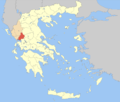
 Αττική (Attiki)English: Attica
 -
 Στερεά Ελλάδα (Sterea Ellada)English: Central Greece
 -
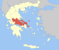
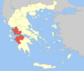
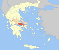
 Κεντρική Μακεδονία (Kentriki Makedonia)English: Central Macedonia
 -
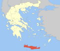 Κρήτη (Kriti)English: Crete
 -
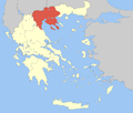
 Ανατολική Μακεδονία και Θράκη (Anatoliki Makedonia kai Thraki)English: East Macedonia and Thrace
 -
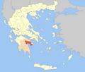
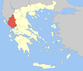 Ήπειρος (Ipiros)English: Epirus
 -
 Ιόνια Νησιά (Ionia Nisia)English: Ionian Islands
 -
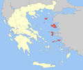 Βόρειο Αιγαίο (Voreio Aigaio)English: North Aegean
 -
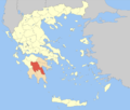
 Πελοπόννησος (Peloponnisos)English: Peloponnesus
 -
 Νότιο Αιγαίο (Notio Aigaio)English: South Aegean
 -
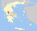
 Θεσσαλία (Thessalia)English: Thessaly
 -
 Δυτική Ελλάδα (Dytiki Ellada)English: Western Greece
 -
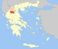
 Δυτική Μακεδονία (Dytiki Makedonia)English: West Macedonia


-
 Αιτωλοακαρνανία (Aitoloakarnania)English: Aetolia-Acarnania
 -
 Αθήνα (Athina)English: Athens
 -
 Ανατολική Αττική (Anatoliki Attiki)English: East Attica
 -
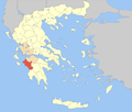
 Αργολίδα (Argolida) (alt. Argolis)
 -
 Αρκαδία (Arkadia)
 -
 Άρτα (Arta)
 -
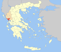
 Αχαΐα (Achaia)
 -
 Βοιωτία (Voiotia)English: Boeotia
 -
 Γρεβενά (Grevena)
 -
 Δράμα (Drama)
 -
 Δωδεκάνησος (Dodekanisos)English: Dodecanese
 -
 Δυτική Αττική (Dytiki Attiki)English: West Attica
 -
 Εύβοια (Evvoia)English: Euboea
 -
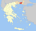
 Έβρος (Evros)
 -
 Ευρυτανία (Evrytania)
 -
 Ζάκυνθος (Zakynthos)
 -
 Ηλεία (Ileia)English: Elis
 -
 Ημαθία (Imathia)
 -
 Ηράκλειο (Iraklio)English: Heraklion
 -
 Θεσπρωτία (Thesprotia)
 -
 Θεσσαλονίκη (Thessaloniki)
 -
 Ιωάννινα (Ioannina)
 -
 Καβάλα (Kavala)
 -
 Καρδίτσα (Karditsa)
 -
 Καστοριά (Kastoria)
 -
 Κέρκυρα (Kerkyra)English: Corfu
 -
 Κεφαλληνία και Ιθάκη (Kefallinia kai Ithaki)English: Kafalonia and Ithaca
 -
 Κοζάνη (Kozani)
 -
 Κορινθία (Korinthia)English: Corinthia
 -
 Κιλκίς (Kilkis)
 -
 Κυκλάδες (Kyklades)English: Cyclades
 -
 Λακωνία (Lakonia)English: Laconia
 -
 Λάρισα (Larisa)
 -
 Λασίθι (Lasithi)
 -

-
 Λευκάδα (Lefkada) (alt. Lefkas)
 -
 Μαγνησία (Magnisia)English: Magnesia
 -
 Μεσσηνία (Messinia)English: Messenia
 -
 Πέλλα (Pella)
 -
 Πιερία (Pieria)
 -
 Πειραιάς (Peiraias)English: Piraeus
 -
 Πρέβεζα (Preveza)
 -
 Ρέθυμνο (Rethymno)
 -
 Ροδόπη (Rodopi)English: Rhodope
 -
 Σάμος (Samos)
 -
 Σέρρες (Serres)
 -
 Ξάνθη (Xanthi)
 -
 Τρίκαλα (Trikala)
 -
 Φλώρινα (Florina)
 -
 Φθιώτιδα (Fthiotida)English: Phthiotis
 -
 Φωκίδα (Fokida)English: Phocis
 -
 Χαλκιδική (Chalkidiki)
 -
 Χανιά (Chania)
 -
 Χίος (Chios)


Other maps

|
Map of the two orthodox patriarcates of Athens (blue) and Constantinople (orange, yellow) |

|
Map of Corinthian Isthmus, German, as well as SVG-Version |
Satellite maps

|
Satellite map of Greece |

|
Satellite map of Greece |
Notes and references
|
General remarks:
|