Atlas of Moldova
Specific status: Akrotiri and Dhekelia‡ · Faroe Islands · Gibraltar · Bailiwick of Guernsey · Isle of Man · Jersey · Svalbard – Limited recognition: Abkhazia‡ · Gagauzia · Kosovo · South Ossetia‡ · Transnistria · Northern Cyprus‡
‡: partly located in Europe

|
Wikimedia Commons Atlas of the World The Wikimedia Atlas of the World is an organized and commented collection of geographical, political and historical maps available at Wikimedia Commons. Discussion • Update the atlas • Index of the Atlas • Atlas in categories • Other atlases on line |
|
| ||||||||||||||||||||||||||||||||||||||||||||


General maps

|
Map of Moldova |

|
Map of Moldova |

|
Map of Moldova (in Romanian) |

|
Map of Moldova (in Ukrainian) |

|
Map of Moldova |

|
Physical geography of Moldova |
| [[|border|251x400px]] | Geology of Moldova |
| [[|border|251x400px]] | Biogeography of Moldova |

|
Moldovan railways |
| [[|border|251x400px]] | Moldovan roads |

|
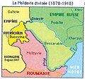
Moldova, Romanian Moldova and Bessarabia |
| Transnistria in Moldova |

|
Gagauzia in Moldova |

|
Gagauzia in Moldova |

|
Moldova and Romania |

|
A hypothetical map of Romania united with Moldova |
Administrative maps

|
Administrative map of Moldova |

|
Administrative map including the development regions |

|
Blank administrative map of Moldova |

|
Administrative divisions of Moldova |

|
The 6 development regions of Moldova |
| [[|border|251x400px]] | Two administrative reforms projected 1990 and 2010 according with the "Swiss example" |

|
Administrative map of the Romanian Orthodox Church (including the Metropolis of Bessarabia) |
Historical maps

|
Kingdom of Dacia 82-44 BC |

|
Province of Dacia within the Roman Empire (AD 106-117) |
.svg)
|
The Roman Province of Dacia (AD 106-275) |

|
Eastern Romance people during the Dark Ages |
-ro.png)
|
Principality of Moldavia in 1483 |

|
Highland, Lowland and Bessarabia in the Principality of Moldavia (until 1812), the russian gubernia & the romanian province of Bessarabia (1812-1940), and present situation |
.png)
|
Principality of Moldavia during the reign of Stephen the Great (1457 - 1504) |
| Romanian principalities united under Michael the Brave (1600) |

|
South-Central Europe in 1683, on the eve of the Ottoman siege of Vienna |

|
Romanian principalities in 1793-1812 |

|
Bukovina as part of the Habsburg Kingdom of Galicia-Lodomeria, the autonomous Principality of Transylvania and the Turkish/Russian divided Moldova |

|
The frontier between Russia and Romania in Southwestern Bessarabia (1856-1878) |

|
Romanian principalities 1856-1859 |

|
United Principalities of Moldova and Wallachia (Romania) |

|
Southeastern Europe in 1856-78 |

|
Development of the European part of the Ottoman Empire |

|
The Russian Empire in 1914 |

|
Development of the Russian Empire (in German) |

|
Bessarabia in 1914 (in Russian) |

|
Historisches Bessarabien und heutige Republik Moldau (in German) |

|
Bessarabia within Romania (after 1918) |
.JPG)
|
Bessarabia as part of Romania and the MASSR as part of the Ukrainian SSR (1924-25) |

|
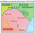
Romania and the MASSR (1924-40) |
| The Moldavian Autonomous Soviet Socialist Republic (MASSR), in 1924-40 part of the Soviet Union (Ukrainian SSR) |

|
Historical regions of interwar Romania |

|
Bessarabia as part of Romania |

|
Romania in 1918-1925, administrative map |

|
Romania in 1926—1940, administrative map |

|
Romania in 1930, administrative map |

|
Romania in 1938, administrative map |

|
Romania in 1938-40, administrative map |

|
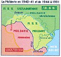
In 1940 Bessarabia is occupied by the Soviet Union and most of it is united with parts of the Moldavian ASSR, forming the Moldavian SSR (1940-1941) |

|
Romania in 1941-44 |

|
Administrative map of Romania in May 1942 |
| Romania controlled in August 19, 1941-January 29, 1944 the region between Dniester and Bug rivers, and the Black Sea coast (Transnistria proper). The region was divided into 13 judeţe (counties). |

|
Romanian territorial losses after World War II |

|
Development of Romania (1881-present day) |

|
Evolution of the Soviet Union |

|
Location of the USSR |

|
The republics of the USSR |

|
Soviet Union administrative divisions, 1989 |

|
Location of the Soviet Socialist Republic of Moldova in the USSR |

|
Transnistria as a russian "protected" separatist territory between 3 others |

|
Former counties of the Republic of Moldova (1998-2003) |
Old maps
This section holds copies of original general maps more than 70 years old.

|
The Moldovan Principality (1716), by Dimitrie Cantemir |

|
Principalities of Moldavia @ Wallachia, italian map (1786), by G. Pittori, according with the geographer Giovanni Antonio Rizzi Zannoni |

|
Governorate of Bessarabia in 1883 |

|
Governorate of Bessarabia |

|
1927 map of Bessarabia |

|
Moldavian ASSR in 1929 |

|
Moldavian ASSR (1930) |

|
1930 map of Bessarabia |

|
Physical map of Bessarabia (in French) |

|
Location map of Bessarabia |
Ethno-linguistic maps
.jpg)
|
Ethnic map of the Ottoman Empire and its vassal states, including Romania (1861) |

|
Ethnic map of European Russia before the First World War (in French) |

|
Territories inhabited by Romanians in 1908 |

|
Romanians living outside Romania before 1918 |

|
Ethnic map of Bessarabia (1918) |

|
Ethnic map of the Moldavian Autonomous Soviet Socialist Republic in 1926 |

|
Ethnic map of Romania in 1930 |

|
Jewish communities in 1930 |

|
Ethnic composition of Bessarabia in 1930 |

|
Ethnic map of Romania and Transnistria in 1941 |

|
Ethnic composition of Bessarabia in 1941 |

|
Ethnic composition of Moldova in 1989 |

|
Ethnic composition of Moldova in 2002 |

|
Romanian dialects |

|
Some representative isoglosses of three main varieties (dialects) of Daco-Romanian |

|
Languages in Moldova and Romania |

|
The dispersion of Moldavians (included romance-speaking Moldovans) in Europe |

|
The distribution of Romanians (including self-declared Moldavians or Vlachs) |

|
Modern distribution of East Romance people |
Historic maps in french of the moldavian region[3]
-
 Antic period.
 -
 During the great migrations (Dridu culture are disputed).
 -
 Duchies of the 13-th & 14-th centuries (their status & area are disputed).
 -
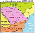 1359-1418.
 -
 1418-1484.
 -
 Under turkish vassality, 16-th century.
 -
 1775-1856.
 -
 1856-1878.
 -
 1878-1917.
 -
 1918-1940, inside Romania.
 -
 1940-1990 borders.
 -
 Since 1991.


Election maps
-
 Votes won by the Communist Party of Moldova (PCRM) in the April 2009 legislative election by raion and municipality
 -
 Votes won by the Liberal Party (PL) in the April 2009 legislative election by raion and municipality
 -
 Votes won by the Liberal Democratic Party of Moldova (PLDM) in the April 2009 legislative election by raion and municipality
 -
 Votes won by the 'Our Moldova' Alliance (AMN) in the April 2009 legislative election by raion and municipality
 -
 Total votes won by the opposition parties (PL, PLDM and AMN) which passed the 6% electoral threshold in the April 2009 legislative election by raion and municipality
 -
 Voter turnout for the April 2009 legislative election by raion and municipality
 -
 Results of the July 2009 legislative election
 -
 Results of the 2010 legislative election


Ethnic maps of Moldova (2004 census)
-
 Harta etnică a Republicii Moldova la nivel de comune
 -
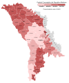
 Ponderea românilor în Republica Moldova la nivel de comune
 -
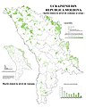 Ponderea ucrainenilor în Republica Moldova la nivel de comune
 -
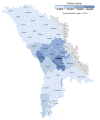
 Ponderea rușilor în Republica Moldova la nivel de comune
 -
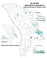
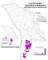 Ponderea găgăuzilor în Republica Moldova la nivel de comune
 -
 Ponderea bulgarilor în Republica Moldova la nivel de comune


Satellite maps

|
Satellite map |
Notes and references
|
General remarks:
|