Atlas of the Comoros

(Redirected from Atlas of Comoros)
Wikimedia Commons Atlas of the World

The Wikimedia Atlas of the World is an organized and commented collection of geographical, political and historical maps available at Wikimedia Commons.
Discussion • Update the atlas • Index of the Atlas • Atlas in categories • Other atlases on line
The introductions of the country, dependency and region entries are in the native languages and in English. The other introductions are in English.
 
Atlas-country
The Comoros


Komori
Comores
جزر القمر

Shikomor Komori - Udzima wa Komori
Français Les Comores - Union des Comores

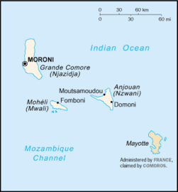
L'Union des Comores est un pays indépendant de l'archipel des Comores dans l'océan Indien. L'archipel des Comores est constitué de quatre îles (La Grande Comore, Mohéli, Anjouan et Mayotte) qui se trouvent dans le canal du Mozambique au Nord-Ouest de Madagascar et face au Mozambique.

العربية [1]جزر القمر - الإتـحـاد القـمـر

ـُزُر القَـمَـر دولة صغيرة قرب قارة إفريقيا في المحيط الهندي، وعاصمتها موروني. هي اتحاد ثلاث جزر مستقلة: موهيلي (فومبوني), أنجوان (موتسامودو), القمر الكبير (موروني). وجزيرة رابعة هي مايوت (ماموتزو) لا تزال تحت إدارة فرنسا وتطالب بها جزر القمر. الاسم السابق كان: جمهورية القمر الإتحادية الإسلامية (بالفرنسية.

English The Comoros - Union of the Comoros

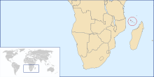
The Union of the Comoros is a country in the Indian Ocean, situated at the northern end of the Mozambique Channel between northern ► Madagascar and northern ► Mozambique, near the French collectivity of ► Mayotte.


Short name  The Comoros
Official name Union of the Comoros
Status Independent country since 1975
Location Southern Africa
Capital Moroni
موروني
Population 897,219 inhabitants
Area 798 square kilometres (308 sq mi)
Major languages Comorian, French, Arabic (all official)
Major religions Islam
More information The Comoros, Geography of The Comoros, History of The Comoros and Politics of The Comoros
More images The Comoros - The Comoros (Category).

General maps

Carte des Comores
Map of the Comoros
Carte des Comores
Same map in French
Carte des Comores et Mayotte
Map of the Comoros and Mayotte
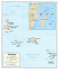
Carte géographique des Comores
Geographical Map of the Comoros
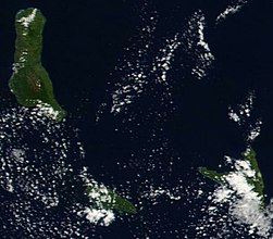
Image satellite des Comores
Satellite image of the Comoros

History maps

This section holds a short summary of the history of the area of present-day the Comoros, illustrated with maps, including historical maps of former countries and empires that included present-day the Comoros.

Over the centuries, the present-day Comoros are invaded by a succession of diverse groups from the coast of Africa, the Persian Gulf, Indonesia, and Madagascar. Portuguese explorers visit the archipelago in 1505. "Shirazi" Arab migrants introduce islam at about the same time. Between 1829 and 1840 the islands, including the island of Mayotte, are united under the Sultanate of Mayotte. This changes between 1843 and 1886, when the sultanate becomes as the Comoros a French protectorate. From 1896 the Comoros are administered from Réunion, but from 1908 the islands are administered from Madagascar. In 1947 the archipelago becomes a French overseas territory named Territoire des Comores (Territory of the Comoros). Internal autonomy is granted in 1961. In 1975 the archipelago achieves independence as the State of the Comoros. After a referendum the island of Mayotte decides to remain a French dependency. In 1978 the Comoros are renamed Federal and Islamic Republic of the Comoros. After a consitutional crisis the Comoros more or less converted into a confederation in 2001 under the name Union of the Comoros.

Notes and references

General remarks:

  • The WIKIMEDIA COMMONS Atlas of the World is an organized and commented collection of geographical, political and historical maps available at Wikimedia Commons. The main page is therefore the portal to maps and cartography on Wikimedia. That page contains links to entries by country, continent and by topic as well as general notes and references.
  • Every entry has an introduction section in English. If other languages are native and/or official in an entity, introductions in other languages are added in separate sections. The text of the introduction(s) is based on the content of the Wikipedia encyclopedia. For sources of the introduction see therefore the Wikipedia entries linked to. The same goes for the texts in the history sections.
  • Historical maps are included in the continent, country and dependency entries.
  • The status of various entities is disputed. See the content for the entities concerned.
  • The maps of former countries that are more or less continued by a present-day country or had a territory included in only one or two countries are included in the atlas of the present-day country. For example the Ottoman Empire can be found in the Atlas of Turkey.
  1. Romanization: Al-Qumur - Ittihad al-Qumur.

Entries available in the atlas

General pages
Atlas   ■ Historical atlas   ■ Index of the Atlas   ■ Names in native languages

The world and its continents and oceans
Quick reference   ■ Historical maps of the world   ■ Old maps
Physical and topographical   ■ Political   ■ Geological   ■ People   ■ Time and time zones   ■ Projections of the globe
Africa   ■ North and South America   ■ Antarctica   ■ Asia   ■ Europe

(History, European Union)   ■ Oceania   ■ Oceans

Themes
Administrative divisions   ■ International organizations   ■ Languages   ■ Religions

Historical eras
Prehistory   ■ Antiquity   ■ Middle Ages   ■ Rise of Islam   ■ Early Modern Age   ■ Early American Societies   ■ Early Asian Societies   ■ Age of Renaissance   ■ Colonialism   ■ Stielers Handatlas 1891   ■ 20th Century   ■ World War I   ■ World War II

Entities with undisputed sovereign status
Afghanistan   ■ Albania   ■ Algeria   ■ Andorra   ■ Angola   ■ Antigua and Barbuda   ■ Argentina   ■ Armenia   ■ Australia   ■ Austria   ■ Azerbaijan   ■ Bahamas   ■ Bahrain   ■ Bangladesh   ■ Barbados   ■ Belarus   ■ Belgium   ■ Belize   ■ Benin   ■ Bhutan   ■ Bolivia   ■ Bosnia and Herzegovina   ■ Botswana   ■ Brazil   ■ Brunei   ■ Bulgaria   ■ Burkina Faso   ■ Burundi   ■ Cambodia   ■ Cameroon   ■ Canada   ■ Cape Verde   ■ Central African Republic   ■ Chad   ■ Chile   ■ China   ■ Colombia   ■ Comoros   ■ Congo (Democratic Republic)   ■ Congo (Republic)   ■ Costa Rica   ■ Côte d’Ivoire   ■ Croatia   ■ Cuba   ■ Cyprus   ■ Czech Republic   ■ Denmark   ■ Djibouti   ■ Dominica   ■ Dominican Republic   ■ East Timor   ■ Ecuador   ■ Egypt   ■ El Salvador   ■ Equatorial Guinea   ■ Eritrea   ■ Estonia   ■ Eswatini   ■ Ethiopia   ■ Fiji   ■ Finland   ■ France   ■ Gabon   ■ Gambia   ■ Georgia   ■ Germany   ■ Ghana   ■ Greece   ■ Grenada   ■ Guatemala   ■ Guinea   ■ Guinea-Bissau   ■ Guyana   ■ Haiti   ■ Honduras   ■ Hungary   ■ Iceland   ■ India   ■ Indonesia   ■ Iran   ■ Iraq   ■ Ireland   ■ Israel   ■ Italy   ■ Jamaica   ■ Japan   ■ Jordan   ■ Kazakhstan   ■ Kenya   ■ Kiribati   ■ Korea (Democratic People’s Republic)   ■ Korea (Republic)   ■ Kuwait   ■ Kyrgyzstan   ■ Laos   ■ Latvia   ■ Lebanon   ■ Lesotho   ■ Liberia   ■ Libya   ■ Liechtenstein   ■ Lithuania   ■ Luxembourg   ■ Madagascar   ■ Malawi   ■ Malaysia   ■ Maldives   ■ Mali   ■ Malta   ■ Marshall Islands   ■ Mauritania   ■ Mauritius   ■ Mexico   ■ Micronesia (Federated States)   ■ Moldova   ■ Monaco   ■ Mongolia   ■ Montenegro   ■ Morocco   ■ Mozambique   ■ Myanmar   ■ Namibia   ■ Nauru   ■ Nepal   ■ Netherlands   ■ New Zealand   ■ Nicaragua   ■ Niger   ■ Nigeria   ■ North Macedonia   ■ Norway   ■ Oman   ■ Pakistan   ■ Palau   ■ Panama   ■ Papua New Guinea   ■ Paraguay   ■ Peru   ■ Philippines   ■ Poland   ■ Portugal   ■ Qatar   ■ Romania   ■ Russia   ■ Rwanda   ■ Saint Kitts and Nevis   ■ Saint Lucia   ■ Saint Vincent and the Grenadines   ■ Samoa   ■ San Marino   ■ São Tomé and Príncipe   ■ Saudi Arabia   ■ Senegal   ■ Serbia   ■ Seychelles   ■ Sierra Leone   ■ Singapore   ■ Slovakia   ■ Slovenia   ■ Solomon Islands   ■ Somalia   ■ South Africa   ■ South Sudan   ■ Spain   ■ Sri Lanka   ■ Sudan   ■ Suriname   ■ Sweden   ■ Switzerland   ■ Syria   ■ Tajikistan   ■ Tanzania   ■ Thailand   ■ Togo   ■ Tonga   ■ Trinidad and Tobago   ■ Tunisia   ■ Turkey   ■ Turkmenistan   ■ Tuvalu   ■ Uganda   ■ Ukraine   ■ United Arab Emirates   ■ United Kingdom   ■ United States   ■ Uruguay   ■ Uzbekistan   ■ Vanuatu   ■ Vatican City   ■ Venezuela   ■ Vietnam   ■ Yemen   ■ Zambia   ■ Zimbabwe

Entities with disputed sovereign status
Abkhazia   ■ Artsakh   ■ Kosovo   ■ Northern Cyprus   ■ Palestine   ■ Somaliland   ■ South Ossetia   ■ Taiwan   ■ Tatarstan   ■ Transnistria   ■ Western Sahara

Dependencies and other overseas territories
Akrotiri and Dhekelia   ■ Åland   ■ American Samoa   ■ Anguilla   ■ Aruba   ■ Ascension Island   ■ Ashmore and Cartier Islands   ■ Baker Island   ■ Bermuda   ■ Bouvet Island   ■ British Indian Ocean Territory   ■ British Virgin Islands   ■ Cayman Islands   ■ Christmas Island   ■ Clipperton Island   ■ Cocos (Keeling) Islands   ■ Cook Islands   ■ Coral Sea Islands   ■ Curaçao   ■ Faroe Islands   ■ French Guiana   ■ French Polynesia   ■ French Southern and Antarctic Lands   ■ Gibraltar   ■ Greenland   ■ Guadeloupe   ■ Guam   ■ Guantanamo Bay   ■ Guernsey   ■ Heard Island and McDonald Islands   ■ Hong Kong   ■ Howland Island   ■ Isle of Man   ■ Jan Mayen   ■ Jarvis Island   ■ Jersey   ■ Johnston Atoll   ■ Kingman Reef   ■ Macau   ■ Martinique   ■ Mayotte   ■ Midway Atoll   ■ Montserrat   ■ Navassa Island   ■ New Caledonia   ■ Niue   ■ Norfolk Island   ■ Northern Mariana Islands   ■ Palmyra Atoll   ■ Pitcairn Islands   ■ Puerto Rico   ■ Réunion   ■ Saint Helena   ■ Saint Martin (France)   ■ Saint-Barthélemy   ■ Saint-Pierre and Miquelon   ■ Sint Maarten (Netherlands)   ■ Svalbard   ■ Tokelau   ■ Tristan da Cunha   ■ Turks and Caicos Islands   ■ United States Virgin Islands   ■ Wake Island   ■ Wallis and Futuna

Disputed subnational entities and territories
Bajo Nuevo Bank   ■ Crimea   ■ Falkland Islands   ■ Gilgit–Baltistan   ■ Kurdistan (Syrian)   ■ Kashmir   ■ Ladakh   ■ Paracel Islands   ■ Serranilla Bank   ■ South Georgia and South Sandwich Islands   ■ Spratly Islands   ■

Subnational autonomous entities
Aceh   ■ Adjara   ■ Adygea   ■ Altai   ■ Andalusia   ■ Aosta Valley   ■ Aragon   ■ Asturias   ■ Athos   ■ Azores   ■ Balearic Islands   ■ Bashkortostan   ■ Basque Autonomous Community   ■ Bonaire   ■ Bosnia and Herzegovina (Federation of)   ■ Bougainville   ■ Brussels   ■ Buryatia   ■ Canary Islands   ■ Catalonia   ■ Chechnya   ■ Chuvashia   ■ Corsica   ■ Dagestan   ■ Easter Island   ■ England   ■ Extremadura   ■ Flanders   ■ Friuli-Venezia Giulia   ■ Gagauzia   ■ Galicia   ■ Galápagos Islands   ■ Gilgit–Baltistan   ■ Gorno-Badakhshan   ■ Guangxi   ■ Ingushetia   ■ Islamabad Capital Territory   ■ Inner Mongolia   ■ Kabardino-Balkaria   ■ Kalmykia   ■ Karachay-Cherkessia   ■ Karakalpakstan   ■ Karelia   ■ Khakassia   ■ Komi   ■ Kurdistan (Iraqi)   ■ Khyber Pakhtunkhwa   ■ Madeira   ■ Mari El   ■ Muslim Mindanao   ■ Mordovia   ■ Nakhichevan   ■ Navarre   ■ Nevis   ■ Ningxia   ■ North Ossetia – Alania   ■ Northern Ireland   ■ Nunatsiavut   ■ Quebec   ■ Saba   ■ Sakha   ■ Sardinia   ■ Scotland   ■ Sicily   ■ Sindh   ■ Sint Eustatius   ■ Srpska   ■ Tibet   ■ Tłı̨chǫ   ■ Trentino-Alto Adige   ■ Tuva   ■ Udmurtia   ■ Vojvodina   ■ Wales   ■ Wallonia   ■ Xinjiang   ■ Zanzibar

Other regions
Basque Country   ■ Burzenland   ■ Catalan Countries   ■ Frisia   ■ Kurdistan   ■ Manchuria   ■ Sápmi   ■ Svenskfinland   ■ Székely Land   ■ Transylvania

Former sovereign nations
Austria-Hungary   ■ Byzantine Empire   ■ Caliphate   ■ Czechoslovakia   ■ Frankish Empire   ■ Kingdom of Hawaiʻi   ■ Inca Empire   ■ Iroquois Confederacy   ■ Macedonian Empire   ■ Ottoman Empire   ■ Prussia   ■ Roman Empire   ■ Soviet Union   ■ Republic of Texas   ■ Vermont Republic   ■ Republic of West Florida   ■ Yugoslavia

Former dependencies and overseas territories
Netherlands Antilles

Former disputed territories
Tamil Eelam


References