Atlas of Serbia
Specific status: Akrotiri and Dhekelia‡ · Faroe Islands · Gibraltar · Bailiwick of Guernsey · Isle of Man · Jersey · Svalbard – Limited recognition: Abkhazia‡ · Gagauzia · Kosovo · South Ossetia‡ · Transnistria · Northern Cyprus‡
‡: partly located in Europe

|
Wikimedia Commons Atlas of the World The Wikimedia Atlas of the World is an organized and commented collection of geographical, political and historical maps available at Wikimedia Commons. Discussion • Update the atlas • Index of the Atlas • Atlas in categories • Other atlases on line |
|
| ||||||||||||||||||||||||||||||||||||||||||

General maps

|
Map of Serbia with Kosovo (as it is recognized by UN) |

|
Map of Serbia |

|
Map of Serbia |

|
Administrative divisions of the Republic of Serbia |

|
Administrative divisions of the Republic of Serbia |

|
Statistical regions of Serbia |

|
Statistical regions of Serbia |

|
Districts of Serbia and Municipalities of Serbia |

|
Districts of Serbia (in Serbian) |

|
Districts of Serbia |
.png)
|
Municipalities of Serbia |

|
Official cities of Serbia |

|
Main cities of Serbia |

|
Main cities of Serbia |
.svg)
|
Flag map |

|
Blank map |

|
Blank map |
.svg)
|
Blank map |

|
Blank map |

|
Geographical regions in Serbia |
.PNG)
|
Vojvodina within Serbia |

|
Vojvodina within Serbia |
.PNG)
|
Kosovo within Serbia |

|
Kosovo within Serbia |
History maps
This section holds a short summary of the history of the area of present-day Serbia, illustrated with maps, including historical maps of former countries and empires that included present-day Serbia.
General history

|
approximate extent of Pannonian Sea during the Miocene Epoch |

|
approximate extent of Pannonian Sea during the Miocene Epoch |

|
approximate extent of Pannonian Sea during the Miocene Epoch |

|
detailed map of the south-eastern part of Pannonian Sea during the Miocene Epoch |

|
detailed map of the south-eastern part of Pannonian Sea during the Miocene Epoch |

|
Lepenski Vir culture (6700-5500 BC) |

|
Starčevo culture (7th-5th milennium BC) |

|
Neolithic Starčevo culture (5300-4400 BC) |

|
Vinča culture (6th-5th milennium BC) |

|
Copper Age Kostolac culture |

|
Vučedol culture (3000-2400 BC) |

|
Vatin culture (16th-13th century BC) |

|
Bronze Age Dubovac-Žuto Brdo culture |

|
Bronze Age Belegiš culture |

|
Iron Age Bosut culture |

|
Ethnic territory of the Illyrians and Illyrian tribes (8th-3rd century BC) |

|
Iron Age Glasinac culture (around 300 BC) |

|
Tribal State of the Scordisci (3rd century BC - 1st century BC) with capital in Singidunum (present-day Belgrade) |

|
Territorial development of the Roman Empire 264 BC-192, including the conquest of present-day territory of Serbia |

|
Roman Republic 100 BCE |

|
Map of the Roman Empire in 50 |

|
The extent of the Roman Republic and Roman Empire; 133 BC 44 BC (late Republic, after conquests by republican generals) AD 14 (death of Augustus) 117 (maximum extension)
|

|
Camps of the Roman Legions in 80 |

|
Map of the Roman Empire in 116 |

|
Dalmatia in the Roman Empire (116) |

|
Moesia Superior in the Roman Empire (116) |

|
Pannonia in the Roman Empire (116) |

|
Dacia in the Roman Empire (116) |

|
Roman Empire in 117 |

|
Roman Empire in 117 |

|
Roman provinces in the territory of present-day Serbia until 273 |

|
Territory of emperor Galerius (whose capital was Sirmium) during the Tetrarchy, 3rd-4th century |

|
Prefecture of Illyricum with capital in Sirmium, 318-379 AD |

|
Prefecture of Illyricum in the 4th century |

|
Prefecture of Illyricum in the 4th century |

|
Roman provinces, 4th century |

|
Roman Empire divided 395, showing the dioceses and praetorian prefectures of Gaul, Italy, Illyricum and Oriens (east), roughly analogous to the four Tetrarch zones of influence after Diocletian's reforms. |

|
The division of the Empire after the death of Theodosius I, ca.395 AD superimposed on modern borders. |

|
Invasions of the Roman Empire 100-500 |

|
Invasions of the Roman Empire 100-500 |

|
Division of the Roman Empire in 406 |
.PNG)
|
Eastern Roman Empire and Western Roman Empire, c.476 |

|
Kingdom of the Gepids in the 6th century (539-551) |

|
Eastern Roman Empire |

|
Eastern Roman Empire under emperor Justinianus |

|
Eastern Roman Empire under emperor Justinianus |

|
Byzantine Empire in 550 |

|
Migration of the Slavs (5th-10th century) |

|
People named Serbi in northern Caucasus (ancient Sarmatia) |

|
People named Serbi in northern Caucasus (ancient Sarmatia) |

|
People named Serbi in northern Caucasus (ancient Sarmatia) |

|
People named Sirbi in northern Caucasus (ancient Sarmatia) |

|
People named Sirbi in northern Caucasus (ancient Sarmatia) |

|
White Serbia in the 6th century (around 560), according to the book of Francis Dvornik |

|
Dervan's Serbia in present-day eastern Germany, 7th century |

|
White Serbia located in Pannonia (according to one of the theories) |
.jpg)
|
White Serbia located in Pannonia (according to one of the theories) |

|
Hypothetical migrations of the Serbs from India (according to one of the theories about origin of the Serbs) |

|
Migration of Serbs from Caucasus (according to Niko Županić) |

|
Migration of Serbs from Caucasus |

|
Hypothetical migration of the Serbs |

|
Migration of Serbs to the Balkans from White Serbia (7th century) |

|
Migration of Serbs to the Balkans from White Serbia (7th century) |

|
Hypothetical migration of the Serbs |

|
Migration of Serbs |

|
Migration of Serbs |

|
Areas where place names with word "Srb" appear |

|
Slavic peoples (7th-8th century) |
| [[|border|251x400px]] | The "Sklavinias" in the Balkans, 7th - 8th century |

|
Presence of South Slavic tribes c. 700 |

|
Location of Great Moravia (9th century) in the territory of present-day Serbia according to the Peter Nagy Puspoki's theory |

|
Serbia under Vlastimir |
.png)
|
Serb lands in the 9th-10th century |

|
Serb lands in the 9th-10th century |
.png)
|
Serb lands in the 10th century |

|
Serb lands in the 10th century |

|
Serbian state in the 10th century |

|
The Byzantine Empire under Basil II, c. 1025 |

|
Byzantine Empire 1025 |

|
South Slavic uprising of Peter Delyan (1040) |
.svg)
|
South Slavic uprising of Peter Delyan (1040-1041) |

|
The Byzantine Empire at the accession of Alexios I Komnenos, c. 1081 |

|
Serbian state in the 11th century |

|
Serbian state in the 11th century |
| [[|border|251x400px]] | Serbian state in the 11th century |

|
Serbia in the 12th century |
| [[|border|251x400px]] | Serbia in the 12th century |

|
Serbian states in the middle 12th century |

|
Serbia in the 12th century |

|
Serbia in the 12th century |

|
Serbian state, 1150-1220 |
| [[|border|251x400px]] | Serbian state, 1168-1196 |
.PNG)
|
Map of the Byzantine Empire under Manuel Komnenos, c.1170. |

|
Byzantine Empire 1180 |

|
Serbia in 1184 |

|
Serbia in 1189 |

|
Serbia in 1265 |

|
Serbia in 1265 |

|
Possession of Darman and Kudelin in the 13th century |

|
Serbian states, 13th-14th century |

|
Serbian states, 13th-14th century |

|
Kingdom of Syrmia of Stefan Dragutin in 1282-1316 |

|
Kingdom of Syrmia of Stefan Dragutin in 1282-1316 (according to the book of historian Stanoje Stanojević) |

|
Medieval Serbian states |

|
The despotate of Epirus and Serbian Empire of Stefan Dušan with capital in Skopje from 1315 to 1358 |

|
Serbian Empire of Stefan Dušan with capital in Skopje in 1350 |

|
Serbian Empire of Stefan Dušan with capital in Skopje in 1350 |

|
Serbian Empire of Stefan Dušan with capital in Skopje in 1350 |

|
Serbian Empire of Stefan Dušan with capital in Skopje |
| [[|border|251x400px]] | Serbian Empire of Stefan Dušan with capital in Skopje |

|
Serbian Empire of Stefan Dušan with capital in Skopje in 1355 |

|
Serbian Empire of Stefan Dušan with capital in Skopje in 1355 |

|
Serbian Empire of Stefan Dušan with capital in Skopje in 1355 |

|
Map of the Serbian Empire in 1360 with territories of local rulers |

|
Empire of the Romans (Greeks) and Serbs and whole Albania (Empire of Simeon Uroš - Siniša), 14th century. |

|
State of župan Nikola Altomanović (1367-1373) |

|
Serbian states in 1373-1395 |

|
Realm of Prince Lazar in the 14th century |

|
Realm of Prince Lazar in the 14th century |

|
Realm of Prince Lazar in the 14th century |

|
Serbia in 1400 |

|
Serbia in the 15th century |

|
Serbian despotate in 1422 |

|
Serbian despotate in 1422 |

|
Serbian despotate in the 15th century |

|
Serbian despotate, 1455-1459 |

|
Possessions of the Serbian despots in Syrmia, Bačka and Banat, 15th-16th century |

|
Banate of Mačva and Banate of Belgrade in 1490 |

|
Empire of Jovan Nenad, 1526-1527 |
| [[|border|251x400px]] | Empire of Jovan Nenad (1526-1527) and Duchy of Radoslav Čelnik (1527-1530) |

|
Duchy of Radoslav Čelnik, 1527-1530 |

|
Growth of the Ottoman Empire |

|
Development of the European part of the Ottoman Empire |

|
Growth of the Ottoman Empire |
| [[|border|251x400px]] | Map of the Ottoman Empire 1566 |

|
Banat uprising in 1594 |

|
Ottoman provinces in the 16th century |

|
Serbian Patriarchate of Peć (16th-17th century) |

|
Approximate territory that, according to various sources, was ethnographically named Rascia (Serbia) between 16th and 18th century |

|
Location of the Ottoman Empire in 1683 |

|
Great Serb migration in 1690 |

|
Habsburg Kingdom of Serbia, 1718-1739 |

|
Habsburg Kingdom of Serbia, 1718-1739 |

|
Habsburg Kingdom of Serbia, 1718-1739 |
.jpg)
|
The southern districts of the Banat of Temeswar in 1740 |

|
Location map of New Serbia (1752-1764) and Slavo-Serbia (1753-1764) in modern-day Ukraine, where Serbs from modern-day north Serbia (Vojvodina) migrated in the middle of the 18th century |

|
Location map of New Serbia (1752-1764) |

|
Detailed map of New Serbia (1752-1764) with names of the settlements. Many of the settlement names are same as settlement names in north Serbia (Vojvodina) |

|
Location map of Slavo-Serbia (1753-1764) |

|
Detailed map of Slavo-Serbia (1753-1764) |

|
Koča's frontier (area of anti-Ottoman rebellion) in 1788 |

|
Pashaluk of Belgrade in 1791 |

|
Pashaluk of Belgrade in the 18th century |

|
Map of the Ottoman Empire 1801 |

|
Karađorđe's Serbia in 1809 |

|
Karađorđe's Serbia in 1813 |

|
Principality of Serbia in 1817 |

|
Principality of Serbia - territorial annexions in 1833 |

|
Principality of Serbia - territorial annexions in 1833 |

|
Principality of Serbia in 1833 |

|
Serbian Vojvodina in 1848 |

|
Principality of Serbia and Serbian Vojvodina in 1848 |

|
Principality of Serbia and Voivodeship of Serbia and Banat of Temeschwar in 1849 |
.png)
|
Voivodeship of Serbia and Banat of Temeschwar in 1849-1860 |

|
Districts of the Voivodeship of Serbia and Banat of Temeschwar (1849-1850) |

|
Districts of the Voivodeship of Serbia and Banat of Temeschwar (1850-1860) |

|
Voivodeship of Serbia and Banat of Temeschwar in 1849-1860 |

|
Voivodeship of Serbia and Banat of Temeschwar in 1849-1860 |

|
Principality of Serbia according to the Treaty of San Stefano in 1878 |

|
Principality of Serbia according to the Treaty of San Stefano in 1878 |

|
The territory received by Serbia after the Russo-Turkish War (1877–1878) |

|
Principality of Serbia after Berlin Congres in 1878-1882 and Kingdom of Serbia in 1882-1912 |

|
Principality of Serbia after Berlin Congres in 1878 |

|
Principality of Serbia after Berlin Congres in 1878 |

|
Serbia between 1878 and 1912 |

|
Balkans from 1856 to 1878 |

|
Principality of Serbia in 1876-1878 |

|
Principality of Serbia in 1879 |

|
Sanjak of Novibazar in 1878 |
.jpg)
|
Kingdom of Serbia in 1888 |

|
Kingdom of Serbia in 1897 |
.JPG)
|
Kingdom of Serbia in 1898 |

|
Balkan states in 1899 |

|
Map showing the territorial claims over the Ottoman Empire in 1912 |

|
Serbian territorial aspirations in 1912-1914 |

|
First Balkan War in 1912 |

|
First Balkan War in 1913 |

|
First Balkan War in 1913 |

|
First Balkan War in 1913 |

|
Kingdom of Serbia after First Balkan War in 1912-1913 |

|
Kingdom of Serbia after Second Balkan War in 1913 |

|
Kingdom of Serbia after Second Balkan War in 1913 |

|
Kingdom of Serbia after Second Balkan War in 1913 |

|
Kingdom of Serbia after Second Balkan War in 1913 |

|
Division of Macedonia in 1913 |

|
Territorial development of Serbia (1817-1913) |

|
Kingdom of Serbia in 1913 |

|
Kingdom of Serbia in 1913 |

|
Kingdom of Serbia in 1913 |

|
Serbia in World War I |

|
Serbia in World War I |

|
Serbia in World War I |

|
Serbia in World War I |

|
Serbia in World War I |
| [[|border|251x400px]] | Lands offered to Serbia by the London agreement in 1915 |

|
Kingdom of Serbia in 1918 |

|
Kingdom of Serbia in 1918 |

|
Yugoslavia in 1919 |

|
Lands gained from Bulgaria after 1919 |
| [[|border|251x400px]] | After World War I, Serbia became in 1918 part of the Kingdom of Serbs, Croats and Slovenes, renamed into Yugoslavia in 1929. This is a map of Yugoslavia in 1930 |

|
Banovinas in Yugoslavia |

|
Banovinas in Yugoslavia |

|
Banovinas in Yugoslavia |

|
Banovinas in Yugoslavia |

|
Danube banovina |

|
Morava banovina |

|
Drina banovina |

|
Zeta banovina |

|
Vardar banovina |

|
Proposal for creation of Banovina of Serbia, 1939-1941 |

|
German invasion of Yugoslavia in 1941 |

|
Nedić's Serbia in 1941 |

|
Nedić's Serbia in 1941-1944 |

|
Banovinas of Nedić's Serbia in 1941 |

|
Danube Banovina in 1941 |

|
Nedić's Serbia in 1941-1944 |

|
Nedić's Serbia in 1941-1944 |

|
Nedić's Serbia in 1941-1944 |

|
Nedić's Serbia in 1941-1943 |

|
Nedić's Serbia in 1941-1943 |

|
Nedić's Serbia in 1943-1944 |

|
Nedić's Serbia in 1941-1944 |

|
Nedić's Serbia in 1941-1944 |

|
Nedić's Serbia in 1941-1944 |

|
Republic of Užice in 1941 |

|
Republic of Užice in 1941 |

|
Republic of Užice in 1941 |

|
Republic of Užice in 1941 |

|
Future Serbia in Greater Yugoslavia according to project of Stevan Moljević (1941) |

|
Future Serbia according to project of Stevan Moljević (1941) |

|
Territory controlled by the Yugoslav Army in the Fatherland (JVuO) in 1942 |

|
"All Serbia", an enlarged Serbia proposed by Milan Nedić in 1943 |

|
Areas of the Yugoslav Army in the Fatherland (JVuO) commanders, according to the truce treaties with the Germans (as of 1943) |

|
Fascist genocide in Serbia in WW2 |

|
Fascist concentration camps in Serbia in WW2 |
.png)
|
Movement of JVuO troops in 1945 |

|
Area under jurisdiction of the National Anti-Fascist Council of the People's Liberation of Sandžak (ZAVNOS), 1943-1945 |

|
Serbia in the Socialist Federal Republic of Yugoslavia, 1945-1992 |

|
Serbia in the Socialist Federal Republic of Yugoslavia, 1945-1992 |

|
Serbia in the Socialist Federal Republic of Yugoslavia, 1945-1992 |

|
Serbia in the Socialist Federal Republic of Yugoslavia, 1945-1992 |

|
Serbia in the Socialist Federal Republic of Yugoslavia, 1945-1992 |

|
Serbia in the Socialist Federal Republic of Yugoslavia, 1945-1992 |

|
Serbia in the Socialist Federal Republic of Yugoslavia, 1945-1992 |

|
Serbia in the Socialist Federal Republic of Yugoslavia, 1945-1992 |

|
Serbia inside Yugoslavia |

|
Proposed division of Yugoslavia by the Pavelić-Stojadinović Agreement from 1954 |

|
Greater Serbia, proposed by Vojislav Šešelj |
_sr.svg)
|
Greater Serbia, proposed by Vojislav Šešelj |

|
Greater Serbia, proposed by Vuk Drašković |

|
An animated series of maps showing the breakup of the second Yugoslavia |

|
Wartime 1992 |

|
Wartime 1992 |

|
Wartime Serbia, 1991-1995 |

|
After the separation of Slovenia, Croatia, Bosnia and Herzegovina and Macedonia, Serbia and Montenegro continued as the Federal Republic of Yugoslavia, renamed in 2003 into Serbia and Montenegro |

|
Federal Republic of Yugoslavia (1992-2003) and Serbia and Montenegro (2003-2006) |

|
Federal Republic of Yugoslavia (1992-2003) and Serbia and Montenegro (2003-2006) |

|
Federal Republic of Yugoslavia (1992-2003) and Serbia and Montenegro (2003-2006) |

|
State of Balkania (proposed by Adem Demaçi in 1993) |

|
Sites in southern Central Serbia where NATO aviation used forbidden munition with depleted uranium during 1999 bombing |

|
Conflict in southern Serbia in 1999–2001 |

|
Map of Serbia and Montenegro |

|
Location of the FR of Yugoslavia (Serbia and Montenegro) before dissolution |

|
Map of Serbia in 2006 |

|
Former Yugoslavia compared with the present borders (2006) |

|
Former Yugoslavia compared with the present borders (2007) |

|
Former Yugoslavia compared with the present borders (2009) |

|
Central Balkans in 2010 (de facto situation). Note: Serbia does not recognizing Independence of Kosovo. |
Maps of the Kosovo conflict

|
Kosovo within Serbia, see also Atlas of Kosovo |

|
Kosovo within Serbia |
.png)
|
Kosovo within Serbia |
Ethnic, linguistic and religion maps
Ethnic maps

|
Ethnic map of the territory of present-day Serbia and neighbouring areas in the 6th-8th century (according to the historical atlas for schools, published in Belgrade in 1970, representing a view of Yugoslav historians from that time) |
.jpg)
|
Ethnic map of the Balkan Peninsula (1861), including Central Serbia and Kosovo |

|
Ethnic map of Eastern Serbia based on the 1866 census |

|
Ethnographic map of the Balkans (1876) |

|
Ethnic map of the Balkans (1880) |
.jpg)
|
Ethnic map of Austria-Hungary (including Serbia), census 1880. German version |

|
Ethnic map of the Balkan Peninsula (1881), including Serbia |
.JPG)
|
Ethnic map of Austria-Hungary (including Serbia), census 1890. English version |

|
Ethnographic map of the Balkans (1897) |

|
Ethnic map of the Balkan Peninsula (1898), including Central Serbia and Kosovo |
.jpg)
|
Ethnographic map of the Balkans (1918) |

|
Serbs in Yugoslavia |

|
Ethnic map, 1991 |

|
Ethnic map, 1991 |

|
Ethnic map of Serbia (by municipalities) - census 2002 |

|
Ethnic map of Serbia (by municipalities) - census 2002 |
.png)
|
Ethnic map of Serbia (by settlements) - census 2002 |
.png)
|
Ethnic map of Serbia (by settlements) - census 2002 |

|
Serbian population in Serbia (census 2002) |

|
Bosniak population in Serbia (census 2002) |

|
Hungarian population in Serbia (census 2002) |

|
Roma (Gipsy) population in Serbia (census 2002) |
.PNG)
|
Roma (Gipsy) population in Serbia (census 2002) |

|
Macedonian population in Serbia (census 2002) |

|
Ethnic map of Serbia (by municipalities) - census 2011 |

|
Ethnic map of Serbia (by municipalities) - census 2011 |
| [[|border|251x400px]] | Ethnic map of Sandžak (1981) |

|
Ethnic map of Sandžak (2002) |

|
Ethnic map of Sandžak (2011) |

|
Vlachs in Central Serbia (2002 census). Note: There are conflicting views about the issue whether Vlachs are separate ethnicity or part of Romanian ethnicity. |

|
Vlachs in Central Serbia (estimations by Viorel Dolha). Note 1: Data presented in this map does not correspond with official data from 2002 census in Serbia, which show Vlach majority in smaller number of settlements. Note 2: There are conflicting views about the issue whether Vlachs are separate ethnicity or part of Romanian ethnicity. |
Linguistic maps

|
Serbo-Croatian language in Serbia (as of 2005) |

|
Serbian language in the region (as of 2006) |

|
Serbian language in the region (as of 2006) |

|
Official recognition of the Serbian language in Serbia and neighbouring countries |

|
Official recognition of the Serbian language in Serbia and neighbouring countries |

|
Historical distribution of Serbo-Croatian dialects in Serbia (before 16th century migrations) |

|
Shtokavian Serbo-Croatian dialects in Serbia |

|
Shtokavian Serbo-Croatian dialects in Serbia |

|
Shtokavian Serbo-Croatian dialects in Serbia |

|
Torlakian dialect |

|
Torlakian dialect |

|
Romanian and Vlach language in Serbia (census 2002). Note: There are conflicting views about the issue whether Vlach is separate language or part of Romanian language. |

|
Municipalities with official usage of Romanian language in Vojvodina (together with Serbian and other languages) |
Religion maps

|
Religion map of the territory of present-day Serbia in 1054 |
.png)
|
Organization of the Serbian Orthodox Church in Serbia |

|
Organization of the Serbian Orthodox Church in former Yugoslavia |

|
Organization of the Serbian Orthodox Church in former Yugoslavia |

|
Organization of the Serbian Orthodox Church in former Yugoslavia |

|
Orthodox Christians in Serbia |

|
Muslims in Serbia |

|
Organization of the Meshihat of the Islamic Community in Serbia, which is part of the Rijaset of the Islamic Community in Bosnia and Herzegovina (as of 2007) |

|
Organization of the Rijaset of the Islamic Community of Serbia (as of 2007) |

|
Organization of the Catholic Church in Serbia |
Political proposals

|
Federalized Serbia (proposed by the League of Social Democrats of Vojvodina in 1999) |

|
New regions in Serbia (proposed by the Democratic Party of Serbia in 2002) |

|
New administrative divisions (regions) of Serbia (proposed by the League For Šumadija in 2004) |

|
Proposed new ethnic autonomies in Serbia |

|
Irredentist territorial pretensions towards Serbia advocated by nationalists in neighbouring countries |
Regional maps

|
Map of Bačka region |

|
Map of Banat region |
.JPG)
|
Map of Syrmia region |

|
Map of Syrmia region |

|
Map of Mačva region |

|
Map of Mačva District in Central Serbia |

|
Map of Šumadija region |

|
Map of Sandžak region |

|
Map of Sandžak region |

|
Map of Timočka Krajina region in Central Serbia |

|
Map of Timočka Krajina region in Central Serbia |

|
Map of Šopluk region |

|
Map of Pančevački Rit |

|
Map of Šajkaška |
Municipalities and cities
-
 Municipalities of Belgrade
 -
 Municipality of Zemun
 -
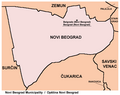 Municipality of Novi Beograd
 -
 Municipality of Surčin
 -
 Municipality of Palilula
 -
 Municipality of Šabac
 -
 Municipality of Bogatić
 -
 Urban local communities in Zemun
 -
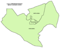
 Urban local communities in Novi Beograd
 -
 Urban local communities in Palilula
 -
 Urban local communities in Borča


Other maps

|
H1N1 presence in Serbia (25 June 2009) |

|
H1N1 presence in Serbia (6 November 2009) |
.svg)
|
Map of Serbia with EU flag |
Satellite maps

|
Satellite map |
Notes and references
|
General remarks:
|