Atlas of the Faroe Islands

|
Wikimedia Commons Atlas of the World The Wikimedia Atlas of the World is an organized and commented collection of geographical, political and historical maps available at Wikimedia Commons. Discussion • Update the atlas • Index of the Atlas • Atlas in categories • Other atlases on line |
This section holds a short summary of the history of the area of present-day the Faroe Islands, illustrated with maps, including historical maps of former countries and empires that included present-day the Faroe Islands.
|
| ||||||||||||||||||||||||||||||||||||||||||
General maps

|
Location of the Faroe Islands |

|
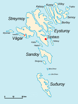
Map of the Faroe Islands |

|
The Faroe Islands, also showing the Vágar airport |

|
The Faroe Islands in the Kingdom of Denmark |

|
Map of the Faroe Islands |

|
Topographic map of the Faroe Islands |

|
The six regions (sýslur) of the Faroe Islands: Blue: Vágar Green: Streymoy Red: Eysturoy Yellow: Norðoyar Violet: Sandoy Turquoise: Suðuroy |

|
Regions of the Faroe Islands |
- See also Maps on Faroese stamps
History maps

|
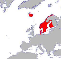
The Faroe Islands were inhabited by Norwegian colonists during the Viking period. It officially became a possesion of Norway in 1035. Denmark seized the Faroe Islands in 1380 and annexed them to Denmark. (This maps shows the islands as part of the Denmark-dominated Kalmar Union in the 16th century.) In 1655 the Danish king gave the islands to the Von Gabel family as a feudal estate, but in 1709 the islands become a Danish crown possession once again. Denmark administered the islands from 1720 as part of Iceland and from 1776 as part of Sjælland County. |

|
Map of Denmark-Norway, including the Faroe Islands, in 1780 |
| The Faroe Islands were given autonomy and their own parliament. In 1816 their autonomy was withdrawn, although the islands become become a separate county as the Faroe Islands. From 1940 to 1945, the islands were under British occupation. In 1948 the Faroe Islands gained internal self-government. |
Old maps
This section holds copies of original general maps more than 70 years old.

|
"Færoarum - Prima & accurata delineatio". Map by Lucas Debes 1673, the first known detailed map of the Faroes |
Other maps
| Isoglosses of the Faroese language |
Satellite maps
| Satellite image |
Notes and references
|
General remarks:
|

